Related Research Articles

Signy Island is a small subantarctic island in the South Orkney Islands of Antarctica. It was named by the Norwegian whaler Petter Sørlle (1884–1933) after his wife, Signy Therese.
The Advisory Committee on Antarctic Names is an advisory committee of the United States Board on Geographic Names responsible for recommending commemorative names for features in Antarctica.
The UK Antarctic Place-Names Committee is a United Kingdom government committee, part of the Foreign and Commonwealth Office, responsible for recommending names of geographical locations within the British Antarctic Territory (BAT) and the South Georgia and the South Sandwich Islands (SGSSI). Such names are formally approved by the Commissioners of the BAT and SGSSI respectively, and published in the BAT Gazetteer and the SGSSI Gazetteer maintained by the Committee. The BAT names are also published in the international Composite Gazetteer of Antarctica maintained by SCAR.

Cook Island is the central and largest island of the Southern Thule island group, part of the South Sandwich Islands in the far south Atlantic Ocean. Southern Thule was discovered by a British expedition under Captain James Cook in 1775. Cook Island was named for Cook by a Russian expedition under Fabian Gottlieb von Bellingshausen, which explored the South Sandwich Islands in 1819–1820.
Visokoi Island is an uninhabited island in the Traversay Islands group of the South Sandwich Islands. It was discovered in 1819 by a Russian expedition under Fabian Gottlieb von Bellingshausen, who named the island Visokoi ("high") because of its conspicuous height. The island was surveyed in 1930 by Discovery Investigations (DI) personnel, who charted and named many of its features. Several of the names given by DI were changed in 1953 by the United Kingdom Antarctic Place-Names Committee (UK-APC) to avoid redundancy with nearby features.

The Usarp Mountains is a major Antarctic mountain range, lying westward of the Rennick Glacier and trending N-S for about 190 kilometres (118 mi). The feature is bounded to the north by Pryor Glacier and the Wilson Hills. Its important constituent parts include Welcome Mountain, Mount Van der Hoeven, Mount Weihaupt, Mount Stuart, Mount Lorius, Smith Bench, Mount Roberts, Pomerantz Tableland, Daniels Range, Emlen Peaks, Helliwell Hills and Morozumi Range.

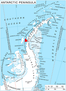
Adelaide Island is a large, mainly ice-covered island, 139 kilometres (75 nmi) long and 37 kilometres (20 nmi) wide, lying at the north side of Marguerite Bay off the west coast of the Antarctic Peninsula. The Ginger Islands lie off the southern end. Mount Bodys is the easternmost mountain on Adelaide Island, rising to over 1,220 m. The island lies within the Argentine, British and Chilean Antarctic claims.

Veststraumen Glacier is a glacier about 45 miles long draining west along the south end of Kraul Mountains into Riiser-Larsen Ice Shelf. The glacier was seen in the course of a U.S. Navy LC-130 plane flight over the coast on November 5, 1967, and was plotted by the United States Geological Survey (USGS) from photographs obtained at that time. In 1969, the Advisory Committee on Antarctic Names (US-ACAN) gave the name "Endurance Glacier" to this feature, but that naming was rescinded because UK Antarctic Place-Names Committee (UK-APC) gave the identical name to a small glacier on Elephant Island. The descriptive name "Veststraumen" appears on a 1972 Norsk Polarinstitutt map.

The Quartermain Mountains are a group of exposed mountains in Antarctica, about 32 kilometres (20 mi) long, typical of ice-free features of the McMurdo Dry Valleys, Victoria Land, located south of Taylor Glacier and bounded by Finger Mountain, Mount Handsley, Mount Feather and Tabular Mountain; also including Knobhead, Terra Cotta Mountain, New Mountain, Beacon Heights, Pyramid Mountain, Arena Valley, Kennar Valley, Turnabout Valley and the several valleys and ridges within Beacon Valley.
Arrowsmith Peninsula is a cape about 40 miles (64 km) long on the west coast of Graham Land, west of Forel Glacier, Sharp Glacier and Lallemand Fjord, and northwest of Bourgeois Fjord, with Hanusse Bay lying to the northwest. It was surveyed by the Falkland Islands Dependencies Survey (FIDS) in 1955-58 and named for Edwin P. Arrowsmith, Governor of the Falkland Islands.

The Willis Islands are a small archipelago to the west of South Georgia Island in the South Georgia Islands. They are 2 miles (3.2 km) west of Bird Island, separated by the Stewart Strait. They were discovered on 14 January 1775 by Captain James Cook and named for Cook's midshipman Thomas Willis, the crew member who first sighted them. The Willis Islands were charted in greater detail and individually named by Discovery Investigations (DI) personnel between 1926-1930.
Explorers Range is a large mountain range in the Bowers Mountains of Victoria Land, Antarctica, extending from Mount Bruce in the north to Carryer Glacier and McLin Glacier in the south. Named by the New Zealand Antarctic Place-Names Committee (NZ-APC) for the northern party of New Zealand Geological Survey Antarctic Expedition (NZGSAE), 1963–64, whose members carried out a topographical and geological survey of the area. The names of several party members are assigned to features in and about this range. All of the geographical features listed below lie situated on the Pennell Coast, a portion of Antarctica lying between Cape Williams and Cape Adare.

The Adare Peninsula, sometimes called the Cape Adare Peninsula, is a high ice-covered peninsula, 40 miles (64 km) long, in the northeast part of Victoria Land, extending south from Cape Adare to Cape Roget. The peninsula is considered the southernmost point of the Borchgrevink Coast, named for Carsten Borchgrevink (1864-1934). The peninsula was named by the New Zealand Antarctic Place-Names Committee (NZ-APC) for Cape Adare.
Alamein Range is a mountain range lying west of Canham Glacier, in the Freyberg Mountains of Antarctica. Named in association with Lord Bernard Freyberg and the Second New Zealand Expeditionary Force by the Northern Party of New Zealand Geological Survey Antarctic Expedition (NZGSAE), 1963–64. The mountain range is situated on the Pennell Coast, a portion of Antarctica lying between Cape Williams and Cape Adare.
Wilson Stream is a meltwater stream which flows from the ice-free lower west slopes of Mount Bird, to the south of Alexander Hill, and over steep sea cliffs into Wohlschlag Bay, Ross Island. Mapped by the New Zealand Geological Survey Antarctic Expedition (NZGSAE), 1958–59, and named by the New Zealand Antarctic Place-Names Committee (NZ-APC) for J. Wilson, mountaineer assistant with the expedition.
Wright Upper Glacier is an ice apron at the upper west end of Wright Valley in Asgard Range, Antarctica. It is formed by a glacier flowing east from the inland ice plateau. Named by the Victoria University of Wellington Antarctic Expedition (VUWAE) (1958–59) for C.S. Wright, a member of the British Antarctic Expedition (1910–13), after whom the "Wright Glacier" was named.
The Freyberg Mountains are a group of mountains in Victoria Land, Antarctica, bounded by Rennick Glacier, Bowers Mountains, Black Glacier, and Evans Neve. Named for New Zealand's most famous General, Lord Bernard Freyberg, by the Northern Party of New Zealand Geological Survey Antarctic Expedition (NZGSAE), 1963-64. This mountain group includes the Alamein Range. These topographical features all lie situated on the Pennell Coast, a portion of Antarctica lying between Cape Williams and Cape Adare.
Fitzgerald Stream is a stream between Fitzgerald Hill and Inclusion Hill on the lower ice-free west slopes of Mount Bird, Ross Island, flowing to McMurdo Sound across McDonald Beach. It was explored by the New Zealand Geological Survey Antarctic Expedition, 1958–59, and named by the New Zealand Antarctic Place-Names Committee for E.B. Fitzgerald, deputy leader of the expedition.
Mount Thundergut is a rock peak 3 nautical miles (6 km) northeast of St. Pauls Mountain in the Asgard Range, Victoria Land. The descriptive name was given by New Zealand Antarctic Place-Names Committee (NZ-APC); when viewed from the east, the peak presents a very steep domed face with a vertical gut subject to rockfall.
Russet Hills is a line of hills trending east–west for 3.5 nautical miles (6 km) and forming the southern ridge of Gallipoli Heights in the Freyberg Mountains. Named by the New Zealand Antarctic Place-Names Committee (NZ-APC) on the proposal of P.J. Oliver, New Zealand Antarctic Research Program (NZARP) geologist who studied the hills, 1981–82. Named descriptively from the red-colored ignimbrite rock of this feature.
References
- ↑ Breisemeister, William A.; Waugh, Douglas V. (1965). Antarctica. Taylor & Francis. p. 98.
- ↑ Evans, A. (1968). "New Zealand Antarctic Place Names Committee". Antarctic. New Zealand Antarctic Society. 5–7.
- ↑ "Arena Saddle". Geographic Names Information System . United States Geological Survey . Retrieved 2011-05-12.
- ↑ "Foggy Pass". Geographic Names Information System . United States Geological Survey . Retrieved 2012-03-29.
- ↑ "Frame Ridge". Geographic Names Information System . United States Geological Survey . Retrieved 2012-04-05.
- ↑ "Marshall Stream". Geographic Names Information System . United States Geological Survey . Retrieved 2013-08-15.
- ↑ "Burrows, Mount". Geographic Names Information System . United States Geological Survey . Retrieved 2011-10-08.
- ↑ "Jennings, Mount". Geographic Names Information System . United States Geological Survey . Retrieved 2012-07-24.
