Cape Adare

Last updated
Antarctica relief location map.jpg
Red pog.svg
Cape Adare
Location of Cape Adare
Antarctica
Area map of Cape Adare AN -Victoria Land.png
Area map of Cape Adare
Topographic map of the Cape Adare region C71188s5 Ant.Map Cape Adare.jpg
Topographic map of the Cape Adare region
Borchgrevink's 1899 hut (HSM 22) surrounded by penguins Borchgrevink Hut.jpg
Borchgrevink's 1899 hut (HSM 22) surrounded by penguins
Nicolai Hanson's grave (HSM 23) - 1899 photograph Tosouthpolarregi00bern 0211.jpg
Nicolai Hanson's grave (HSM 23) – 1899 photograph
Adelie penguins on an ice foot at Cape Adare - photo by George Murray Levick, 1911 or 1912 Levick-Adelie-Penguins.jpg
Adélie penguins on an ice foot at Cape Adare – photo by George Murray Levick, 1911 or 1912
Adelie penguins at Cape Adare Cape adere.JPG
Adélie penguins at Cape Adare

Cape Adare is a prominent cape of black basalt forming the northern tip of the Adare Peninsula and the north-easternmost extremity of Victoria Land, East Antarctica. [1]

Contents

Description

Marking the north end of Borchgrevink Coast and the west end of Pennell Coast, the cape separates the Ross Sea to the east from the Southern Ocean to the west, and is backed by the high Admiralty Mountains. Cape Adare was an important landing site and base camp during early Antarctic exploration. Off the coast to the northeast are the Adare Seamounts and the Adare Trough.

History

Captain James Ross discovered Cape Adare in January 1841 and named it after his friend the Viscount Adare (the title is derived from Adare, Ireland).

In January 1895, Norwegian explorers Henrik Bull and Carsten Borchgrevink from the ship Antarctic landed at Cape Adare as the first documented landing on Antarctica, collecting geological specimens. Borchgrevink returned to the cape leading his own expedition in 1899 and erected two huts, the first human structures built in Antarctica. The expedition members overwintered and the survivors were picked up in January 1900. This was the first expedition party ever to winter over on the Antarctic continent. Zoologist Nicolai Hanson died during the winter and was buried at Cape Adare.

The closest research station in modern times was Hallett Station, the joint New Zealand/United States station at Cape Hallett, 63 miles (101 km) to the south. This base was in use from 1957 to 1973.

The Australian Bicentennial Antarctic Expedition set out from Cape Adare for their successful assault on Mount Minto in 1988. The expedition's support vessel was moored to the ice shelf in the bay and maintained radio contact with the climbers during their ascent.

In February 2007, the Japanese whaling ship Nisshin Maru experienced a fire below decks while in the Ross Sea. [2] The vessel drifted without power for days until its engines were repaired, raising concern among New Zealand authorities due to its proximity to the world's largest Adélie penguin rookery at Cape Adare. [3]

Historic sites and monuments

The first buildings erected by Carsten Borchgrevink at Cape Adare were prefabricated of pine by the Norwegian factory Strømmen Trævarefabrikk. These huts are still standing, and the site is recognized internationally as a significant historic site. Members of the Northern Party of Scott's Terra Nova Expedition over-wintered at Cape Adare in 1911 and 1912. They erected one hut, which has fallen into ruin today.

As a result of initiatives by the Antarctic Heritage Trust the site (with the buildings) is registered in the Antarctic Treaty System as an Antarctic Specially Protected Area (ASPA 159) the highest level of protection available under the terms of the Treaty. [4] [5]

The remains of two Borchgrevink's Hut, as well as those of the Terra Nova Expedition's hut, have also been designated a Historic Site or Monument (HSM 22), following a proposal by New Zealand and the United Kingdom to the Antarctic Treaty Consultative Meeting. The grave of Nicolai Hanson has been similarly but separately designated (HSM 23). [6]

Climate

Studies suggests that Cape Adare was covered in ice during the Last glacial period, and deglaciated around 16.2 thousand years ago. And the results suggest that it took several thousand years until penguin colonies formed, after ice free surfaces became available. [7]

Iceberg interactions

Submarine shoals on the narrow continental shelf to the east of Cape Adare are the site of unusually frequent submarine collisions with large current-mobilized icebergs transiting northward out of the Ross Sea. Notably, this process led to the sudden breakup of Iceberg B15 in October 2007, as well as a number of other large icebergs. These collisions are energetic enough to be recorded by seismographs in Antarctica and the southern Pacific Ocean region. [8]

Adélie penguins

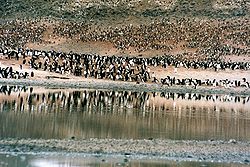
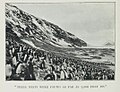
Cape Adare is the site of the largest Adélie penguin rookery in the world. [9] The only study of this particular colony was done by George Murray Levick, [9] who was a member of the 1910–13 Scott Antarctic Expedition and observed it for an entire breeding cycle in 1911 and 1912. [10] He was reluctant to publish it due to the unusual mating habits of penguins that he recorded, among them homosexuality, sexual and physical abuse of chicks, and mating with dead female penguins, nowadays ascribed to the lack of experience of young penguins. [10] He described it as "depraved". The report was considered too shocking for public release at the time, and was suppressed. The only copies that were made available privately to researchers were translated into Greek, to prevent this knowledge becoming more widely known. After it became lost, it was rediscovered and published in the journal Polar Record only in 2012. The discovery significantly illuminates the behaviour of the species that some researchers [11] believe to be an indicator of climate change. [10]

Important Bird Area

Over four seasons, sampled between 1981 and 2012, the Adélie colony at Cape Adare had a mean count of 227,000 breeding pairs, making it (along with that at Cape Crozier) among the largest in the Ross Sea. It occupies Ridley Beach and part of the western slopes of the Cape Adare peninsula. A 294 ha site encompassing the colony has been designated an Important Bird Area by BirdLife International. A colony of about 300 pairs of south polar skuas is also present. [12]

In 1901, Carsten Borchgrevink, part of the British Antarctic Expedition 1898–1900, published the book, ‘First on the Antarctic continent’. He wrote ca. 1900, in the chapter dedicated to Adélie penguins:

We all watched the life of the penguins with the utmost interest, and I believe and hope that some of us learnt something from their habits and characteristics. [13]

See also

Related Research Articles

<span class="mw-page-title-main">Carsten Borchgrevink</span> Norwegian polar explorer (1864–1934)

Carsten Egeberg Borchgrevink was a Norwegian polar explorer and a pioneer of Antarctic travel. He inspired Sir Robert Falcon Scott, Sir Ernest Shackleton, Roald Amundsen, and others associated with the Heroic Age of Antarctic Exploration.

<span class="mw-page-title-main">Timeline of New Zealand's links with Antarctica</span>

This is a timeline of the history of New Zealand's involvement with Antarctica.

<span class="mw-page-title-main">Hope Bay</span> Bay of Antarctica

Hope Bay on Trinity Peninsula, is five kilometres long and three kilometres wide, indenting the tip of the Antarctic Peninsula and opening on Antarctic Sound. It is the site of the Argentinian Antarctic settlement Esperanza Base, established in 1952.

<span class="mw-page-title-main">Cape Hallett</span> Antarctic research station

Cape Hallett is a snow-free area on the northern tip of the Hallett Peninsula on the Ross Sea coast of Victoria Land, East Antarctica. Cape Adare lies 100 km (62 mi) to the north.

<span class="mw-page-title-main">Paulet Island</span> Island of Antarctica

Paulet Island is a circular island about 1.5 km (0.93 mi) in diameter, lying 4.5 km (2.8 mi) south-east of Dundee Island, off the north-eastern end of the Antarctic Peninsula. Because of its large penguin colony, it is a popular destination for sightseeing tours.

<span class="mw-page-title-main">Duke of York Island (Antarctica)</span> Island of Antarctica

Duke of York Island is a mountainous ice-free island, 2.5 miles (4 km) long, lying in the southern part of Robertson Bay, Antarctica, along the northern coast of Victoria Land. It was first charted in 1899 by the British Antarctic Expedition, under Carsten Borchgrevink, who named it for the then Duke of York, later George V. This island lies situated within the borders known as the Pennell Coast, a portion of Antarctica lying between Cape Williams and Cape Adare.

<span class="mw-page-title-main">Cape Denison</span> Headland of Antarctica

Cape Denison is a rocky point at the head of Commonwealth Bay in George V Land, Antarctica. It was discovered in 1912 by the Australasian Antarctic Expedition (1911–14) under Douglas Mawson, who named it for Sir Hugh Denison of Sydney, a patron of the expedition. The cape was the site of the expedition's main base. Called by Mawson "the windiest place on Earth", the site experiences fierce katabatic winds.

<span class="mw-page-title-main">George Murray Levick</span> British explorer and naval surgeon (1876–1956)

George Murray Levick was a British Antarctic explorer, naval surgeon and founder of the Public Schools Exploring Society.

<span class="mw-page-title-main">Inexpressible Island</span> Island of Antarctica

Inexpressible Island is a small, rocky island in Terra Nova Bay, Victoria Land, Antarctica. Previously uninhabited, the Chinese Qinling research station on the southern edge of the island became operational in 2024.

<span class="mw-page-title-main">Cape Crozier</span> Headland of Antarctica

Cape Crozier is the most easterly point of Ross Island in Antarctica. It was discovered in 1841 during James Clark Ross's expedition of 1839 to 1843 with HMS Erebus and HMS Terror, and was named after Commander Francis Crozier, captain of HMS Terror, one of the two ships of Ross' expedition.

<span class="mw-page-title-main">Foyn Island</span> Island of Antarctica

Foyn Island, also known as Svend Foyn Island, is the second largest island in the Possession Islands, East Antarctica, lying 6 kilometres (4 mi) south-west of Possession Island. An Adélie penguin rookery covers much of the island, which is often included in the itinerary of Antarctic cruises.

<span class="mw-page-title-main">Adare Peninsula</span> Mountain in Ross Dependency, Antarctica

The Adare Peninsula, is a high ice-covered peninsula, 40 nautical miles long, in the northeast part of Victoria Land, extending south from Cape Adare to Cape Roget. The peninsula was named by the New Zealand Antarctic Place-Names Committee (NZ-APC) for Cape Adare. The peninsula is considered the southernmost point of the Borchgrevink Coast, named for Carsten Borchgrevink (1864-1934).

<i>Southern Cross</i> Expedition 1898–1900 research expedition to Antarctica

The Southern CrossExpedition, otherwise known as the British Antarctic Expedition, 1898–1900, was the first British venture of the Heroic Age of Antarctic Exploration, and the forerunner of the more celebrated journeys of Robert Falcon Scott and Ernest Shackleton. The brainchild of the Anglo-Norwegian explorer Carsten Borchgrevink, it was the first expedition to over-winter on the Antarctic mainland, the first to visit the Great Ice Barrier—later known as the Ross Ice Shelf—since Sir James Clark Ross's groundbreaking expedition of 1839 to 1843, and the first to effect a landing on the Barrier's surface. It also pioneered the use of dogs and sledges in Antarctic travel.

<span class="mw-page-title-main">Robertson Bay</span> Bay in Antarctica

Robertson Bay is a large, roughly triangular bay that indents the north coast of Victoria Land between Cape Barrow and Cape Adare. Discovered in 1841 by Captain James Clark Ross, Royal Navy, who named it for Dr. John Robertson, surgeon on HMS Terror.

<span class="mw-page-title-main">Rookery Islands</span> Islands of Antarctica

The Rookery Islands are a group of rocks and small islands in western Holme Bay, north of the David and Masson Ranges, on the Mawson Coast of Mac.Robertson Land in East Antarctica. The largest in the group are Giganteus Island in the north-west, 600 m long by 400 m wide, and Rookery Island in the south, 1 km long and 250 m wide. The islands are rocky and of low relief, rising to heights of 60 m on Rookery Island, 25 m on Giganteus Island, and ranging from 10 – 30 m on the smaller islands. The nearest permanent research station is Australia's Mawson, some 15 km to the east in Holme Bay.

<span class="mw-page-title-main">Nicolai Hanson</span> Norwegian zoologist and Antarctic explorer (1870–1899)

Nicolai Hanson was a Norwegian zoologist and Antarctic explorer. Nicolai Hanson was a member of the Southern Cross Expedition led by Carsten Borchgrevink to Antarctica and he became the first person to be buried in Antarctica.

<span class="mw-page-title-main">Borchgrevink Coast</span> Portion of coast of Antarctica

The Borchgrevink Coast is that portion of the coast of Victoria Land between Cape Adare and Cape Washington. The name was recommended by New Zealand Antarctic Place-Names Committee in 1961 after Carsten Borchgrevink, a member of Henrik Johan Bull's expedition to this area, 1894–95, and leader of the British Antarctic Expedition, 1898–1900, the first to winter on the continent, at Cape Adare.

Haswell Island is the largest of the Haswell Islands, lying off the coast of Antarctica, about 3 kilometres (1.5 nmi) north of Mabus Point in Queen Mary Land. It was discovered by the Western Base Party of the Australasian Antarctic Expedition, 1911–14, under Mawson, and named by him for Professor William A. Haswell, a zoologist at Sydney University and a member of the expedition's Advisory Committee.

Lewis Bay is a bay indenting the north coast of Ross Island, Antarctica, between Mount Bird and Cape Tennyson.

<span class="mw-page-title-main">Per Savio</span> Norwegian polar explorer

Per John Savio was a Norwegian polar explorer and dog sled driver. As a member of the Southern Cross expedition 1898–1900, Savio together with Ole Must were the first to overnight on the Antarctic continent. He was also part of the sled team who were the first persons to travel on the Ross Ice Shelf and reaching a new Farthest South record.

References

  1. PD-icon.svg This article incorporates public domain material from "Cape Adare". Geographic Names Information System . United States Geological Survey.
  2. "Japan cuts short Antarctic whale hunt". NBC News. 2007-02-28. Retrieved 2024-01-08.
  3. "New Zealand demands Japan urgently move its stricken whaler from Antarctic coast - International Herald Tribune". 2007-03-14. Archived from the original on 2007-03-14. Retrieved 2024-01-08.
  4. Historic Sites of the Antarctic
  5. "Cape Adare, Borchgrevink Coast" (PDF). Management Plan for Antarctic Specially Protected Area No. 159: Measure 2, Annex L. Antarctic Treaty Secretariat. 2005. Retrieved 2013-02-06.
  6. "List of Historic Sites and Monuments approved by the ATCM (2012)" (PDF). Antarctic Treaty Secretariat. 2012. Retrieved 2013-10-27.
  7. "The last deglaciation of Cape Adare, northern Victoria Land, Antarctica". British Antarctic Survey. 2008.
  8. Martin, S., Drucker, R., Aster, R., Davey. F., Okal E., Scambos T., and MacAyeal, D., Kinematic and seismic analysis of giant tabular iceberg breakup at Cape Adare, Antarctica, J. Geophys. Res., 115, B06311, doi:10.1029/2009JB006700, 2010
  9. 1 2 "Shock at sexually 'depraved' penguins led to 100-year censorship". The Week. 10 June 2012. Archived from the original on 23 December 2017. Retrieved 10 June 2012.
  10. 1 2 3 McKie, Robin (9 June 2012). "'Sexual depravity' of penguins that Antarctic scientist dared not reveal". Guardian.co.uk.
  11. Ainley, David G. (2002). THE ADÉLIE PENGUIN: BELLWETHER OF CLIMATE CHANGE . Columbia University Press. pp.  310 pp. with 23 illustrations, 51 figures, 48 tables, 16 plates. ISBN   0-231-12306-X.
  12. "Cape Adare". BirdLife Data Zone. BirdLife International. 2015. Retrieved 26 October 2020.
  13. Carsten Borchgrevink (1901). First on the Antarctic continent: Being an account of the British Antarctic expedition, 1898-1900. p. 210.

71°17′S170°14′E / 71.283°S 170.233°E / -71.283; 170.233