
The South Shetland Islands are a group of Antarctic islands with a total area of 3,687 km2 (1,424 sq mi). They lie about 120 kilometres north of the Antarctic Peninsula, and between 430 and 900 km southwest of the nearest point of the South Orkney Islands. By the Antarctic Treaty of 1959, the islands' sovereignty is neither recognized nor disputed by the signatories and they are free for use by any signatory for non-military purposes.
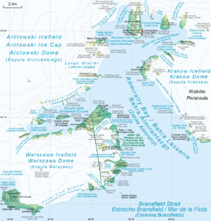
Admiralty Bay is an irregular bay, 8 km (5 mi) wide at its entrance between Demay Point and Martins Head, indenting the southern coast of King George Island for 16 km (10 mi), in the South Shetland Islands of Antarctica. The name appears on a map of 1822 by Captain George Powell, a British sailor, and is now established in international usage. The Henryk Arctowski Polish Antarctic Station is situated on the bay, as is the Comandante Ferraz Brazilian Antarctic Base. It has been designated an Antarctic Specially Managed Area.

Penguin Island is one of the smaller of the South Shetland Islands of Antarctica.

Cape Shirreff is a prominent cape at the north end of the rocky peninsula which separates Hero Bay and Barclay Bay on the north coast of Livingston Island, in the South Shetland Islands of Antarctica. The cape was named by Edward Bransfield in 1820 after Captain William H. Shirreff, the British commanding officer in the Pacific at that time.

Yankee Harbour is a small inner harbour entered from Shopski Cove between Glacier Bluff and Spit Point, indenting the south-west side of Greenwich Island in the South Shetland Islands, Antarctica. It is 2.35 km (1.46 mi) long in west-south-west to east-north-east direction, and 1.6 km (0.99 mi) wide, and is bounded by Provadiya Hook to the south-west, Parvomay Neck to the north and east, and Kladara Beach to the south.

Byers Peninsula is a mainly ice-free peninsula forming the west end of Livingston Island in the South Shetland Islands of Antarctica. It occupies 60 km2 (23 sq mi), borders Ivanov Beach to the northeast and is separated from Rotch Dome on the east by the ridge of Urvich Wall. The peninsula features more than 60 meltwater streams and as many lakes, notably Midge Lake, Limnopolar Lake and Basalt Lake. Byers Peninsula has a regime of special environmental protection under the Antarctic Treaty System and requires a permit to enter.

Barnard Point is a headland which marks the south-east side of the entrance to False Bay on the south side of Livingston Island in the South Shetland Islands, Antarctica. It is situated on Rozhen Peninsula, 1.5 km (1 mi) north-north-west of Botev Point and 6.6 km (4 mi) south-east of Miers Bluff.

Heywood Island is the largest of the islands off the north coast of Robert Island in the South Shetland Islands, Antarctica. It is named after Captain Peter Heywood, RN (1773–1831), commanding HMS Nereus off the east coast of South America in 1810–13, formerly a midshipman in HMS Bounty under Captain William Bligh. The area was visited by early 19th century sealers operating from nearby Clothier Harbour.

Ardley Island is an island 1.9 kilometres (1 nmi) long, lying in Maxwell Bay close off the south-west end of King George Island, in the South Shetland Islands of Antarctica. It was charted as a peninsula in 1935 by Discovery Investigations personnel of the Discovery II and named for Lieutenant R.A.B. Ardley, Royal Naval Reserve, an officer on the ship in 1929–31 and 1931–33. Aerial photography has since shown that the feature is an island with Braillard Point being the headland forming the northeast end of Ardley Island. It has been designated an Antarctic Specially Protected Area because of the importance of its seabird colonies.

Dodman Island is an island 6.5 km (4.0 mi) long, lying 7.4 km (4.6 mi) south-east of Rabot Island and 18.5 km (11.5 mi) west of Ferin Head, off the west coast of Graham Land, Antarctica. The island was charted and named by the British Graham Land Expedition, 1934–37, under John Rymill.
Potter Peninsula is a low ice-free peninsula between Potter Cove and Stranger Point in south-west King George Island, in the South Shetland Islands of Antarctica. It is protected as ASPA 132, largely because of the richness and diversity of its flora and fauna.

Pottinger Point is a low-lying, ice-free promontory 4 km (2.5 mi) east of Round Point, about 500 m long, on the north coast of King George Island in the South Shetland Islands of Antarctica. It was named by the United Kingdom Antarctic Place-Names Committee (UK-APC) in 1960 for Captain Pottinger, Master of the Tartar from London, who visited the South Shetland Islands in 1821–22.
Eadie Island is an island 2 km (1.2 mi) long which lies between Aspland Island and O'Brien Island, in the South Shetland Islands of Antarctica. A strong marine channel, named Tasman Rip, runs between Eadie Island and O'Brien Island.
False Round Point is a point 16 km (9.9 mi) west of North Foreland and 4 km (2.5 mi) south of Ridley Island, on the north coast of King George Island in the South Shetland Islands of Antarctica. The point has appeared on charts since about 1822. It was probably named for its similarity to Round Point, which lies 22 km (14 mi) to the west, by Discovery Investigations personnel on the Discovery II who charted the north coast of this island in 1937.
Lions Rump is a conspicuous headland 2 km (1.2 mi) north-northeast of Low Head, forming the west side of the entrance to King George Bay, on King George Island, in the South Shetland Islands of Antarctica. It was charted and given its descriptive name in 1937 by Discovery Investigations personnel on the Discovery II. Chopin Ridge runs between Lions Rump and Low Head. The rock feature known as "Martello Tower" lies 4 km (2.5 mi) to the north-northwest.
Kellick Island is an island 1 kilometre (0.5 nmi) long, lying 2 kilometres (1 nmi) north-east of Round Point, off the north coast of King George Island in the South Shetland Islands of Antarctica. It was named by the UK Antarctic Place-Names Committee in 1960 for Captain Kellick, Master of the British sealer Henry, who visited the South Shetland Islands in 1821–22.

Point Wordie is a headland on the western coast of Elephant Island, in the South Shetland Islands of Antarctica. The site is named after James Wordie, a Scottish geologist who participated in Ernest Shackleton’s Imperial Trans-Antarctic Expedition, 1914–1917.
Narębski Point is a headland on the south-east coast of the Barton Peninsula, at the south-western end of King George Island, in the South Shetland Islands of Antarctica with an average elevation of 0 feet (0 m) above sea level. Korea’s King Sejong Station lies 2 km (1.2 mi) to the north-east.
Sugarloaf Island is a conspicuous small island which lies close to the east side of Clarence Island, midway between Cape Lloyd and Cape Bowles, in the South Shetland Islands, Antarctica. It lies 3.2 km north of Lebed Point, on the northern side of the entrance to Istros Bay. The name was in use by American and British sealers as early as 1822 and is now well established.

Frisius Point is the rocky north entrance point of Malak Sechko Cove and southwest entrance point of Golyam Sechko Cove projecting 450 m westwards from the northwest coast of Guangzhou Peninsula on Nelson Island in the South Shetland Islands, Antarctica. The area was visited by early 19th century sealers. Frisius Point is part of both Antarctic Specially Protected Area Harmony Point and the BirdLife International Important Bird Area Harmony Point, Nelson Island.

