
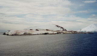
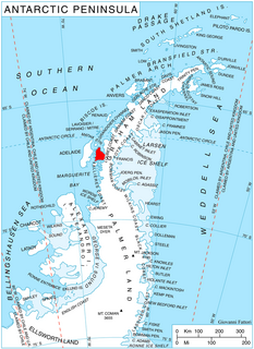
Hummer Point is the eastern point of the ice-covered Gurnon Peninsula, an eastern arm of Bear Peninsula, on the Walgreen Coast of Marie Byrd Land, Antarctica, [1] extending into the Amundsen Sea. [2]
Hummer Point is the eastern point of the ice-covered Gurnon Peninsula, an eastern arm of Bear Peninsula, on the Walgreen Coast of Marie Byrd Land, Antarctica, [1] extending into the Amundsen Sea. [2]
The headland was mapped by the United States Geological Survey from surveys and U.S. Navy aerial photographs from 1959 to 1966, and was named by the Advisory Committee on Antarctic Names in 1977 after Dr Michael G. Hummer. [1]
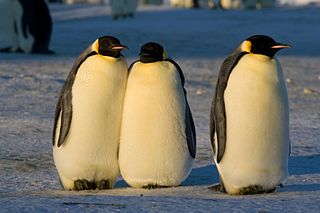
A 490 ha site on fast ice east of the headland has been designated an Important Bird Area (IBA) by BirdLife International because it supports a breeding colony of about 9,500 emperor penguinss, estimated from 2009 satellite imagery. [2]

Thurston Island is an ice-covered, glacially dissected island, 215 km (134 mi) long, 90 km (56 mi) wide and 15,700 km2 (6,062 sq mi) in area, lying a short way off the northwest end of Ellsworth Land, Antarctica. It is the third largest island of Antarctica, after Alexander Island and Berkner Island.
Petermann Island is a small, low and rounded island, lying off the northwest coast of Kiev Peninsula in Graham Land, Antarctica, a short distance south of Booth Island and the Lemaire Channel. It is a popular tourist destination.

Bear Peninsula is a peninsula about 80 km (50 mi) long and 40 km (25 mi) wide which is ice covered except for several isolated rock bluffs and outcrops along its margins, lying 48 km 30 mi) east of Martin Peninsula on Walgreen Coast, Marie Byrd Land, Antarctica.

Trinity Island or Île de la Trinité or Isla Trinidad is an island 24 km (15 mi) long and 10 km (6 mi) wide in the northern part of the Palmer Archipelago, Antarctica. It lies 37 km (23 mi) east of Hoseason Island,72.6 km (45 mi) south of Deception Island in the South Shetland Islands, and 10.3 km (6 mi) north-northwest of Cape Andreas on the Antarctic Peninsula. The island was named by Otto Nordenskiöld, leader of the 1901-1904 Swedish Antarctic Expedition (SAE) in commemoration of Edward Bransfield's "Trinity Land" of 1820.
Lützow-Holm Bay is a large bay, about 220 kilometres (120 nmi) wide, indenting the coast of Queen Maud Land in Antarctica between Riiser-Larsen Peninsula and the coastal angle immediately east of the Flatvaer Islands. It was discovered by Captain Hjalmar Riiser-Larsen in two airplane flights from his expedition vessel, the Norvegia, on February 21 and 23, 1931. The name honours Commander Finn Lützow-Holm of the Royal Norwegian Navy Air Service, a pilot for Captain Riiser-Larsen on the Aagaard in 1935.
Arrowsmith Peninsula is a cape about 40 miles (64 km) long on the west coast of Graham Land, west of Forel Glacier, Sharp Glacier and Lallemand Fjord, and northwest of Bourgeois Fjord, with Hanusse Bay lying to the northwest. It was surveyed by the Falkland Islands Dependencies Survey (FIDS) in 1955-58 and named for Edwin Porter Arrowsmith, Governor of the Falkland Islands.
Hut Point Peninsula is a long, narrow peninsula from 3 to 5 km wide and 24 km (15 mi) long, projecting south-west from the slopes of Mount Erebus on Ross Island, Antarctica. McMurdo Station (US) and Scott Base (NZ) are Antarctic research stations located on the Hut Point Peninsula.
Barff Peninsula is a peninsula forming the east margin of Cumberland East Bay, South Georgia Island. It is 8 miles (13 km) long and extends northwest from Sörling Valley to Barff Point, its farthest extremity. It was probably first seen by the British expedition under James Cook in 1775. The peninsula as a whole takes its name from Barff Point, which was named for Royal Navy Lieutenant A.D. Barff of HMS Sappho, who, assisted by Captain C.A. Larsen, sketched a map of Cumberland Bay in 1906. Barff Point is considered the eastern headland of East Cumberland Bay.

Clark Peninsula is a rocky peninsula, about 3 km (2 mi) long and wide, lying 5 km (3 mi) north-east of Australia's Casey Station at the north side of Newcomb Bay on the Budd Coast of Wilkes Land in Antarctica.

Barnard Point is a headland which marks the south-east side of the entrance to False Bay on the south side of Livingston Island in the South Shetland Islands, Antarctica. It is situated on Rozhen Peninsula, 1.5 km (1 mi) north-north-west of Botev Point and 6.6 km (4 mi) south-east of Miers Bluff.
Worley Point is a narrow, flat and rocky headland extending about 1 km along the north-western coast of Shepard Island, Marie Byrd Land, Antarctica. As with Grant Island, 9 km eastward, Shepard Island is surrounded by the Getz Ice Shelf except on its northern side. The point was named by the Advisory Committee on Antarctic Names (US-ACAN) for Lieutenant Richard J. Worley, U.S. Navy, Medical Officer at South Pole Station in 1969.
The Brownson Islands are a group of about 20 small islands which lie just outside the entrance to Cranton Bay, about 14 nautical miles (26 km) southwest of the southwest tip of the Canisteo Peninsula. They comprises four main islands surrounded by manysmaller islets and rocks, and are largely ice-free in summer. They were delineated from aerial photographs taken by U.S. Navy Operation Highjump in December 1946, and named by the Advisory Committee on Antarctic Names for the USS Brownson, a vessel of the eastern task group of this expedition.
Campbell Glacier is a glacier, about 60 nautical miles (110 km) long, originating near the south end of Mesa Range and draining southeast between the Deep Freeze Range and Mount Melbourne to discharge into north Terra Nova Bay. The lower end of the glacier was observed by the Northern Party, led by Lieutenant Victor Campbell, Royal Navy, of the British Antarctic Expedition, 1910–13; it was named for the leader of this party. The extent of the glacier and its discharge into north Terra Nova Bay, rather than the Nansen Ice Sheet, was determined by United States and New Zealand survey parties to the area in 1961–62 and 1962–63. The steep bluff along the east side of the glacier is known as Hades Terrace, Bier Point is a projecting headland on the eastern side of Campbell Glacier.

Cheal Point is a rocky headland 2 km (1.2 mi) east-south-east of Return Point, the south-western extremity of Coronation Island, in the South Orkney Islands of Antarctica.
Coyer Point is an ice-covered headland on the southeast side of the Martin Peninsula. It is the north end of an ice-covered peninsula that extends into Dotson Ice Shelf, 23 nautical miles (43 km) south-southeast of Jacobsen Head, Bakutis Coast, Marie Byrd Land. It was mapped by the United States Geological Survey from surveys and from U.S. Navy aerial photographs, 1959–67, and Landsat imagery, 1972–73. It was named by the Advisory Committee on Antarctic Names in 1977 after Lieutenant Ann E. Coyer, U.S. Navy, the first U.S. Navy woman to participate in Antarctic operations, who took part in Operation Deep Freeze, 1974.
False Round Point is a point 16 km (9.9 mi) west of North Foreland and 4 km (2.5 mi) south of Ridley Island, on the north coast of King George Island in the South Shetland Islands of Antarctica. The point has appeared on charts since about 1822. It was probably named for its similarity to Round Point, which lies 22 km (14 mi) to the west, by Discovery Investigations personnel on the Discovery II who charted the north coast of this island in 1937.

Ferguslie Peninsula is a peninsula 2.4 km (1.5 mi) long, lying between Browns Bay and Macdougal Bay on the north coast of Laurie Island, in the South Orkney Islands of Antarctica. The peninsula was charted in 1903 by the Scottish National Antarctic Expedition under William Speirs Bruce, who named it for Ferguslie, the residence of James Coats, chief patron of the expedition.
Fraser Point is a point between Marr Bay and Mackintosh Cove on the north coast of Laurie Island, in the South Orkney Islands of Antarctica. It was mapped by the Scottish National Antarctic Expedition in 1903, and in 1912–13 by Captain Petter Sorlle. It was remapped in 1933 by Discovery Investigations personnel on the Discovery II who named it for Francis C. Fraser.

McDonald Beach is an extensive beach lying west of Inclusion Hill and 6 nautical miles (11 km) southwest of Cape Bird on Ross Island, Antarctica. It was named by the New Zealand Geological Survey Antarctic Expedition (NZGSAE), 1958–59, after Captain Edwin A. McDonald, then Deputy Commander, US Naval Support Force, Antarctica, who provided extensive transport and other facilities to the NZGSAE in support of the survey of the Cape Bird area.
Sorenson Glacier is a glacier between Moore Dome and Rogers Spur on Bear Peninsula, flowing west into Dotson Ice Shelf on Walgreen Coast, Marie Byrd Land. Mapped by United States Geological Survey (USGS) from surveys and U.S. Navy aerial photographs, 1959–67. Named in 1977 by Advisory Committee on Antarctic Names (US-ACAN) after Jon E. Sorenson, civil engineer, USGS, a member of the satellite surveying team at South Pole Station, winter party 1975.
![]()
Coordinates: 74°22′S110°15′W / 74.367°S 110.250°W
| This Marie Byrd Land location article is a stub. You can help Wikipedia by expanding it. |