
Fur Seal Point, sometimes referred to as Fur Seal Beach, is a cape midway along the eastern coast of Clarence Island, the easternmost of the South Shetland Islands of Antarctica. Just off the headland lies the small Sugarloaf Island.
Fur Seal Point, sometimes referred to as Fur Seal Beach, is a cape midway along the eastern coast of Clarence Island, the easternmost of the South Shetland Islands of Antarctica. Just off the headland lies the small Sugarloaf Island.
A 205 ha site at the headland has been identified as an Important Bird Area (IBA) by BirdLife International because it supports a large breeding colony of about 57,000 pairs of chinstrap penguins. It is also one of only two known nesting sites for southern fulmars on Clarence Island, the other being Escarpada Point. [1]
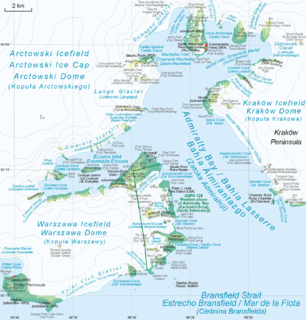
Admiralty Bay is an irregular bay, 8 km (5 mi) wide at its entrance between Demay Point and Martins Head, indenting the southern coast of King George Island for 16 km (10 mi), in the South Shetland Islands of Antarctica. The name appears on a map of 1822 by Captain George Powell, a British sailor, and is now established in international usage. The Henryk Arctowski Polish Antarctic Station is situated on the bay, as is the Comandante Ferraz Brazilian Antarctic Base. It has been designated an Antarctic Specially Managed Area.

Cape Lookout, also known as Cabo Fossatti or Cabo Vigia, is a steep cape, 240 m high, marking the southern extremity of Elephant Island in the South Shetland Islands of Antarctica. The name Cape Lookout appears on a map of 1822 by Captain George Powell, a British sealer, and is now established in international usage.

Barnard Point is a headland which marks the south-east side of the entrance to False Bay on the south side of Livingston Island in the South Shetland Islands, Antarctica. It is situated on Rozhen Peninsula, 1.5 km (1 mi) north-north-west of Botev Point and 6.6 km (4 mi) south-east of Miers Bluff.

Castle Rock National Wildlife Refuge is 0.5 miles (0.80 km) offshore from Crescent City in northern California. This coastal rock covers approximately 14 acres (57,000 m2), and rises steeply 335 feet (102 m) above sea level. The refuge provides an important sanctuary for the Aleutian cackling goose and nesting seabirds.

Cape Bowles is a cape forming the southern extremity of Clarence Island in the South Shetland Islands of Antarctica. It was named in 1820 by Edward Bransfield, Master, Royal Navy, while exploring the islands in the brig Williams.
Chinstrap Cove is a cove 6 km (3.7 mi) north-east of Escarpada Point on the north-west coast of Clarence Island, South Shetland Islands, Antarctica entered northeast of Vaglen Point. The cove has been identified as an Important Bird Area (IBA) by BirdLife International because it supports a large breeding colony of about 20,000 pairs of chinstrap penguins, after which it was named by the UK Joint Services Expedition which visited the site in 1970–1971. The 74 ha IBA includes the ice-free area south of the cove, extending 2 km along the coast.

Stinker Point is a headland 7 km (4.3 mi) south of Table Bay and 2.2 km (1.4 mi) northwest of Piperkov Point on the west coast of Elephant Island, in the South Shetland Islands of Antarctica. It was mapped by the UK Joint Services Expedition to Elephant Island, 1970–71, and named after the southern giant petrels which breed there, "stinker" being an old sailors' name for the bird.

Escarpada Point, also known as Craggy Point, is the rocky, rugged south-west point of Clarence Island in the South Shetland Islands of Antarctica. The descriptive name was given in the course of Argentine government visits in 1953–1954.

False Round Point is a point 16 km (9.9 mi) west of North Foreland and 4 km (2.5 mi) south of Ridley Island, on the north coast of King George Island in the South Shetland Islands of Antarctica. The point has appeared on charts since about 1822. It was probably named for its similarity to Round Point, which lies 22 km (14 mi) to the west, by Discovery Investigations personnel on the Discovery II who charted the north coast of this island in 1937.
Fraser Point is a point between Marr Bay and Mackintosh Cove on the north coast of Laurie Island, in the South Orkney Islands of Antarctica. It was mapped by the Scottish National Antarctic Expedition in 1903, and in 1912–13 by Captain Petter Sorlle. It was remapped in 1933 by Discovery Investigations personnel on the Discovery II who named it for Francis C. Fraser.
Lions Rump is a conspicuous headland 2 km (1.2 mi) north-northeast of Low Head, forming the west side of the entrance to King George Bay, on King George Island, in the South Shetland Islands of Antarctica. It was charted and given its descriptive name in 1937 by Discovery Investigations personnel on the Discovery II. Chopin Ridge runs between Lions Rump and Low Head. The rock feature known as "Martello Tower" lies 4 km (2.5 mi) to the north-northwest.

The Phillip Island Important Bird Area comprises a 20 km2 strip of coastline along the south and west coasts of Phillip Island, Victoria, in south-eastern Australia.

Cape Melville, is a low-lying, ice-free headland at the eastern end of King George Island in the South Shetland Islands of Antarctica. Some 388 ha of the site has been identified as an Important Bird Area (IBA) by BirdLife International because it supports a large breeding colony of about 16,000 pairs of chinstrap penguins.
East of Nelly Point Important Bird Area is a 35 ha, ice-free tract of land on the south-eastern coast of Elephant Island, in the South Shetland Islands of Antarctica. It is a small, unnamed headland, some 2.5 km east of Nelly Point, which has been referred to unofficially as Chinstrap Camp. The site has been identified as an Important Bird Area (IBA) by BirdLife International because it supports a large breeding colony of about 24,000 pairs of chinstrap penguins.
Point Wordie is a headland on the western coast of Elephant Island, in the South Shetland Islands of Antarctica. The site is named after James Wordie, a Scottish geologist who participated in Ernest Shackleton’s Imperial Trans-Antarctic Expedition, 1914–1917.
Saddleback Point is a headland on the northern coast of Elephant Island, in the South Shetland Islands of Antarctica. The site lies 2 km (1.2 mi) to the west of Point Wild.
North Foreland is an ice-free headland on the northern coast of King George Island, the largest of the South Shetland Islands of Antarctica. It lies at the eastern entrance to Emerald Cove, 4.5 km east of Milosz Point, extending northwards for about 2 km and forming the northernmost extremity of the Island.

Baily Head is a prominent headland, 160 m high, forming the easternmost extremity of Deception Island, in the South Shetland Islands of Antarctica.
Sugarloaf Island is a conspicuous small island which lies close to the east side of Clarence Island, midway between Cape Lloyd and Cape Bowles, in the South Shetland Islands, Antarctica. It lies 3.2 km north of Lebed Point, on the northern side of the entrance to Istros Bay. The name was in use by American and British sealers as early as 1822 and is now well established.

The Ryder Bay Islands Important Bird Area is a 520 ha designated site on the south-east coast of Adelaide Island, Antarctica. It has been identified as an Important Bird Area (IBA) by BirdLife International because it supports significant numbers of breeding seabirds, notably south polar skuas. The site encompasses the Léonie Islands lying at the mouth of Ryder Bay, as well as Rothera Point, the eastern headland of the bay.
Coordinates: 61°12′S54°00′W / 61.200°S 54.000°W
| | This Clarence Island (South Shetland Islands) location article is a stub. You can help Wikipedia by expanding it. |