
Tamatea / Dusky Sound is a fiord on the southwest corner of New Zealand, in Fiordland National Park.
Wiencke Island is an island 26 km (16 mi) long and from 3 to 8 km wide, about 67 km2 (26 sq mi) in area, the southernmost of the major islands of the Palmer Archipelago, lying between Anvers Island to its north across the Neumayer Channel and the west coast of the Antarctic Peninsula to its east across the Gerlache Strait.

Stonington Island is a rocky island lying 1.8 km (1.1 mi) northeast of Neny Island in the eastern part of Marguerite Bay off the west coast of Graham Land, Antarctica. It is 0.75 km (0.47 mi) long from north-west to south-east and 0.37 km (0.23 mi) wide, yielding an area of 20 ha. It was formerly connected by a drifted snow slope to Northeast Glacier on the mainland. Highest elevation is Anemometer Hill which rises to 25 m (82 ft).
Trinity Island or Île de la Trinité or Isla Trinidad is an island 24 km (15 mi) long and 10 km (6 mi) wide in the northern part of the Palmer Archipelago, Antarctica. It lies 37 km (23 mi) east of Hoseason Island, 72.6 km (45 mi) south of Deception Island in the South Shetland Islands, and 10.3 km (6 mi) north-northwest of Cape Andreas on the Antarctic Peninsula. The island was named by Otto Nordenskiöld, leader of the 1901-1904 Swedish Antarctic Expedition (SAE) in commemoration of Edward Bransfield's "Trinity Land" of 1820.

Cape Shirreff is a prominent cape at the north end of the rocky peninsula which separates Hero Bay and Barclay Bay on the north coast of Livingston Island, in the South Shetland Islands of Antarctica. The cape was named by Edward Bransfield in 1820 after Captain William H. Shirreff, the British commanding officer in the Pacific at that time.

Yankee Harbour is a small inner harbour entered from Shopski Cove between Glacier Bluff and Spit Point, indenting the south-west side of Greenwich Island in the South Shetland Islands, Antarctica. It is 2.35 km (1.46 mi) long in west-south-west to east-north-east direction, and 1.6 km (0.99 mi) wide, and is bounded by Provadiya Hook to the south-west, Parvomay Neck to the north and east, and Kladara Beach to the south.

Ardley Island is an island 1.9 kilometres (1 nmi) long, lying in Maxwell Bay close off the south-west end of King George Island, in the South Shetland Islands of Antarctica. It was charted as a peninsula in 1935 by Discovery Investigations personnel of the Discovery II and named for Lieutenant R.A.B. Ardley, Royal Naval Reserve, an officer on the ship in 1929–31 and 1931–33. Aerial photography has since shown that the feature is an island with Braillard Point being the headland forming the northeast end of Ardley Island. It has been designated an Antarctic Specially Protected Area because of the importance of its seabird colonies.
Buchanan Point is a headland 5 km (3.1 mi) north-west of Cape Dundas and 2 km (1.2 mi) south-east of Mackintosh Cove, at the north-eastern end of Laurie Island in the South Orkney Islands of Antarctica.

Watson Peninsula is a narrow peninsula 4 km (2.5 mi) long separating Macdougal and Marr Bays on the north coast of Laurie Island, in the South Orkney Islands of Antarctica. It was charted in 1903 by the Scottish National Antarctic Expedition under Bruce, who named it for G.L. Watson, yacht designer and redesigner of the expedition ship Scotia.
D'Urville Monument is a conspicuous conical summit, 575 m (1,886 ft) high, at the south-west end of Joinville Island, off the north-east end of the Antarctic Peninsula. It was discovered by a British expedition under James Clark Ross between 1839–43. It was named by him for Captain Jules Dumont d'Urville.

Cape Davidson is a cape which marks the southernmost part of Mackenzie Peninsula and the west side of the entrance to Wilton Bay, in the west part of Laurie Island in the South Orkney Islands of Antarctica. It was charted in 1903 by the Scottish National Antarctic Expedition under William Speirs Bruce, who named it for J. Davidson, first mate of the expedition ship Scotia.
The Tupinier Islands are a group of pyramid-shaped islands lying off the north coast of Trinity Peninsula, about 6 km (3.7 mi) west of Cape Ducorps. They were discovered by the French expedition under Captain Jules Dumont d'Urville, 1837–40, and named after Baron Tupinier (1779–1850), an official of the French Naval Ministry who was instrumental in obtaining government support for the expedition. The islands were recharted by the Falkland Islands Dependencies Survey (FIDS) in 1946.
Pirie Peninsula is a narrow peninsula extending 6 km (3.7 mi) northward from the center of Laurie Island, in the South Orkney Islands of Antarctica. The peninsula was surveyed in 1903 by the Scottish National Antarctic Expedition under Bruce, who named it for Dr Harvey Pirie, surgeon and geologist of the expedition.

Eillium Island is a small island 2.2 km (1.4 mi) north-west of Rumbo Punta, the north-west tip of Laurie Island in the South Orkney Islands of Antarctica. It was first seen and roughly charted by Captain George Powell and Captain Nathaniel Palmer during their joint cruise in 1821. It was recharted in 1903 by the Scottish National Antarctic Expedition under Dr. William S. Bruce, who named it for his son Eillium.
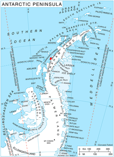
Cape Evensen is a cape forming the north side of the entrance to Auvert Bay, on the northwest coast of Stresher Peninsula, Graham Land in Antarctica. It was discovered by the French Antarctic Expedition, 1903–05, and named by Jean-Baptiste Charcot for Captain C.J. Evensen of the Hertha, who explored along the west coast of the Antarctic Peninsula in 1893.

Ferguslie Peninsula is a peninsula 2.4 km (1.5 mi) long, lying between Browns Bay and Macdougal Bay on the north coast of Laurie Island, in the South Orkney Islands of Antarctica. The peninsula was charted in 1903 by the Scottish National Antarctic Expedition under William Speirs Bruce, who named it for Ferguslie, the residence of James Coats, chief patron of the expedition.
Ferrier Peninsula is a narrow peninsula, 2.4 km (1.5 mi) long, forming the eastern end of Laurie Island in the South Orkney Islands of Antarctica. It was roughly charted in 1823 by a British sealing expedition under James Weddell. It was surveyed in 1903 by the Scottish National Antarctic Expedition under William Speirs Bruce, who named it for his secretary J.G. Ferrier, who was also manager in Scotland of the expedition.
Fraser Point is a point between Marr Bay and Mackintosh Cove on the north coast of Laurie Island, in the South Orkney Islands of Antarctica. It was mapped by the Scottish National Antarctic Expedition in 1903, and in 1912–13 by Captain Petter Sorlle. It was remapped in 1933 by Discovery Investigations personnel on the Discovery II who named it for Francis C. Fraser.
Graptolite Island is an island 0.8 km (0.50 mi) long in the north-east part of Fitchie Bay, lying off the south-east portion of Laurie Island in the South Orkney Islands of Antarctica. James Weddell's chart published in 1825 shows two islands in essentially this position. Existence of a single island was determined in 1903 by the Scottish National Antarctic Expedition under William Speirs Bruce, who so named it because what were thought to be graptolite fossils were found there. Later analysis showed that the fossils on Graptolite Island were merely the remains of ancient plants.
Point Martin is a point on the east side of Mossman Peninsula, 1.5 km (0.93 mi) north-west of Cape Murdoch, on the south coast of Laurie Island in the South Orkney Islands of Antarctica. It was charted in 1903 by the Scottish National Antarctic Expedition under Bruce, who named it for J. Martin, an able seaman on the expedition ship Scotia.
