
The history of Antarctica emerges from early Western theories of a vast continent, known as Terra Australis, believed to exist in the far south of the globe. The term Antarctic, referring to the opposite of the Arctic Circle, was coined by Marinus of Tyre in the 2nd century AD.

Sir Douglas Mawson OBE FRS FAA was an Australian geologist, Antarctic explorer, and academic. Along with Roald Amundsen, Robert Falcon Scott, and Sir Ernest Shackleton, he was a key expedition leader during the Heroic Age of Antarctic Exploration.

Jules Sébastien César Dumont d'Urville was a French explorer and naval officer who explored the south and western Pacific, Australia, New Zealand, and Antarctica. As a botanist and cartographer, he gave his name to several seaweeds, plants and shrubs, and places such as d'Urville Island in New Zealand.

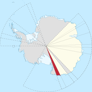
The Australian Antarctic Territory (AAT) is a part of East Antarctica claimed by Australia as an external territory. It is administered by the Australian Antarctic Division, an agency of the federal Department of Climate Change, Energy, the Environment and Water. The territory's history dates to a claim on Enderby Land made by the United Kingdom in 1841, which was subsequently expanded and eventually transferred to Australia in 1933. It is the largest territory of Antarctica claimed by any nation by area. In 1961, the Antarctic Treaty came into force. Article 4 deals with territorial claims, and although it does not renounce or diminish any pre-existing claims to sovereignty, it also does not prejudice the position of Contracting Parties in their recognition or non-recognition of territorial sovereignty. As a result, only four other countries — New Zealand, the United Kingdom, France, and Norway recognise Australia's claim to sovereignty in Antarctica.

Adélie Land or Adélie Coast is a claimed territory of France located on the continent of Antarctica. It stretches from a portion of the Southern Ocean coastline all the way inland to the South Pole. France has administered it as one of five districts of the French Southern and Antarctic Lands since 1955 and applied the Antarctic Treaty System rules since 1961. Article 4 of the Antarctic Treaty deals with territorial claims, and although it does not renounce or diminish any preexisting claims to sovereignty, it also does not prejudice the position of contracting parties in their recognition or non-recognition of territorial sovereignty. France has had a permanent station in Adélie Land since April 9, 1950.

Polar drift is a geological phenomenon caused by variations in the flow of molten iron in Earth's outer core, resulting in changes in the orientation of Earth's magnetic field, and hence the position of the magnetic north- and south poles.
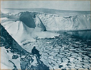
Commonwealth Bay is an open bay about 48 km (30 mi) wide at the entrance between Point Alden and Cape Gray in Antarctica. It was discovered in 1912 by the Australasian Antarctic Expedition under Douglas Mawson, who established the main base of the expedition at Cape Denison at the head of the bay. Named by Australasian Antarctic Expedition after the Commonwealth of Australia.

The Scullin Monolith is a crescent-shaped rock fronting the sea 6 km (3.7 mi) west of the similar Murray Monolith, and 8 km (5.0 mi) from Torlyn Mountain, in Mac. Robertson Land, Antarctica. It is a steep massif of metasedimentary gneiss and granitic origin, with the adjacent coastline consisting of 40 m high ice cliffs. The monolith rises steeply to extend from 435 m high Mikkelsen Peak westward in a crescent that forms Douglas Bay.

Sabrina Coast is that portion of the coast of Wilkes Land, Antarctica, lying between Cape Waldron, at 115° 33' E, and Cape Southard, at 122° 05' E. John Balleny has long been credited with having seen land in March 1839 at about 117° E.
George V Coast is that portion of the coast of Antarctica lying between Point Alden, at 148°2′E, and Cape Hudson, at 153°45′E.
The French Antarctic Expedition is any of several French expeditions in Antarctica.
Oates Land is a region of Antarctica. It is variously defined as a portion of the East Antarctica near the coast stretching along and inland from the Oates Coast and as an officially delineated wedge-shaped segment of the Australian Antarctic Territory. The segment of the Australian claim extends between 153°45' E and 160° E, forming a wedge between Latitude 60° S and the South Pole. It is bounded in the east by the Ross Dependency and overlaps George V Land to the west.

Mount Biscoe is a distinctive black peak, the easternmost and largest of two ice-free rock massifs located 6 km south-west of Cape Ann on the coast of Enderby Land in Antarctica. About 700 m in height, it lies 7 km north-west of Wordie Nunatak, and 7 km north-east of Mount Hurley.
Wilkes Land crater is an informal term that may apply to two separate cases of conjectured giant impact craters hidden beneath the ice cap of Wilkes Land, East Antarctica. These are separated below under the heading Wilkes Land anomaly and Wilkes Land mascon (mass concentration), based on terms used in their principal published reference sources.
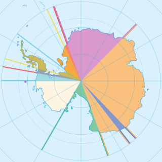
Seven sovereign states – Argentina, Australia, Chile, France, New Zealand, Norway, and the United Kingdom – have made eight territorial claims in Antarctica. These countries have tended to place their Antarctic scientific observation and study facilities within their respective claimed territories; however, a number of such facilities are located outside of the area claimed by their respective countries of operation, and countries without claims such as China, India, Italy, Japan, Pakistan, Russia, South Africa (SANAE), Ukraine, and the United States have constructed research facilities within the areas claimed by other countries. There are overlaps among the territories claimed by Argentina, Chile, and the United Kingdom.

Antarctica is Earth's southernmost and least-populated continent. Situated almost entirely south of the Antarctic Circle and surrounded by the Southern Ocean, it contains the geographic South Pole. Antarctica is the fifth-largest continent, being about 40% larger than Europe, and has an area of 14,200,000 km2 (5,500,000 sq mi). Most of Antarctica is covered by the Antarctic ice sheet, with an average thickness of 1.9 km (1.2 mi).
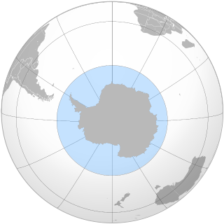
The Southern Ocean, also known as the Antarctic Ocean, comprises the southernmost waters of the world ocean, generally taken to be south of 60° S latitude and encircling Antarctica. With a size of 20,327,000 km2 (7,848,000 sq mi), it is regarded as the second-smallest of the five principal oceanic divisions: smaller than the Pacific, Atlantic, and Indian oceans but larger than the Arctic Ocean. Since the 1980s, the Southern Ocean has been subject to rapid climate change, which has led to changes in the marine ecosystem.

Queen Maud Land is a roughly 2.7-million-square-kilometre (1.0-million-square-mile) region of Antarctica claimed by Norway as a dependent territory. It borders the claimed British Antarctic Territory 20° west and the Australian Antarctic Territory 45° east. In addition, a small unclaimed area from 1939 was annexed in June 2015. Positioned in East Antarctica, it makes out about one-fifth of the continent, and is named after the Norwegian queen Maud of Wales (1869–1938).

The south magnetic pole, also known as the magnetic south pole, is the point on Earth's Southern Hemisphere where the geomagnetic field lines are directed perpendicular to the nominal surface. The Geomagnetic South Pole, a related point, is the south pole of an ideal dipole model of the Earth's magnetic field that most closely fits the Earth's actual magnetic field.


