
Davis Sea is an area of the sea along the coast of East Antarctica between West Ice Shelf in the west and the Shackleton Ice Shelf in the east, or between 82° and 96°E. The name "Davis Sea" appears in most leading geographically authoritative publications such as the 2014 10th edition World Atlas from the National Geographic Society and the 2014 12th edition of the Times Atlas of the World, unlike neighboring proposed water body names such as a Russian proposed "Cooperation Sea" name to the west.

Shackleton Ice Shelf is an extensive ice shelf fronting the coast of East Antarctica from 95° E to 105° E. It extends for an along-shore distance of about 384 kilometres (239 mi), projecting seaward about 145 kilometres (90 mi) in the western portion and 64 kilometres (40 mi) in the east. It occupies an area of 33,820 square kilometres (13,058 sq mi). It is part of Mawson Sea and separates the Queen Mary Coast to the west from the Knox Coast of Wilkes Land to the east.
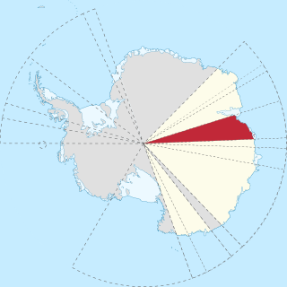
Princess Elizabeth Land is the sector of Antarctica between longitude 73° east and Cape Penck. The sector is claimed by Australia as part of the Australian Antarctic Territory, although this claim is not widely recognized.

The Amery Ice Shelf is a broad ice shelf in Antarctica at the head of Prydz Bay between the Lars Christensen Coast and Ingrid Christensen Coast. It is part of Mac. Robertson Land. The name "Cape Amery" was applied to a coastal angle mapped on 11 February 1931 by the British Australian New Zealand Antarctic Research Expedition (BANZARE) under Douglas Mawson. He named it for William Bankes Amery, a civil servant who represented the United Kingdom government in Australia (1925–28). The Advisory Committee on Antarctic Names interpreted this feature to be a portion of an ice shelf and, in 1947, applied the name Amery to the whole shelf.

Denman Glacier is a glacier 11 to 16 km wide, descending north some 110 km (70 mi), which debouches into the Shackleton Ice Shelf east of David Island, Queen Mary Land. It was discovered in November 1912 by the Western Base party of the Australasian Antarctic Expedition under Sir Douglas Mawson. Mawson named the glacier for Lord Denman, Governor-General of Australia in 1911, a patron of the expedition.

Princess Astrid Coast is a portion of the coast of Queen Maud Land, Antarctica, lying between 5° and 20° E. The entire coast is bordered by ice shelves. The region was discovered by Capt. H. Halvorsen of the Sevilla (ship) in March 1931 and in 1932 was named for Princess Astrid of Norway. The ice of the continental glacier, which is up to 4,000 meters thick in the interior. These thick glaciers are held in place by coastal mountain ranges. On the Princess Astrid Coast, some of the ice does flow through the mountains, spilling onto the relatively flat land on the Princess Astrid Coast. Also, the cold air spills over the mountains, creating very strong and persistent winds, which makes the snow scour off the tops of the glaciers leaving pale blue patches of bare ice. On top of the coastal line is the ice shelf, which is much smoother. The glacial ice floats on the sea surface which is beyond the chaotic surface of the sea ice which has been solidifying all winter long.
The Bakutis Coast is that part of the coast of Marie Byrd Land, West Antarctica, extending from a point opposite eastern Dean Island, at 74°42′S127°05′W, to Cape Herlacher, or between Hobbs Coast in the west and Walgreen Coast in the east. It stretches between 127°05'W and 114°12'W. The coast in this area is bounded by several large ice-covered islands and the very extensive Getz Ice Shelf. This coast was sighted by members of the US Antarctic Service, 1939–1941, and was charted in part from air photos taken by Operation Highjump, 1946–1947, both expeditions led by Admiral Richard E. Byrd. The United States Geological Survey completely mapped the coast from ground surveys and U.S. Navy air photos, 1959–1966.
Ruppert Coast is that portion of the coast of Marie Byrd Land, Antarctica, between Brennan Point and Cape Burks, or between Saunders Coast in the west and Hobbs Coast in the east. It stretches from 146°31'W to 136°50'W. It was named by R. Admiral Richard Byrd for Col. Jacob Ruppert of New York, a supporter of the second Byrd Antarctic Expedition (1933–1935) that made the first aerial reconnaissance flight along this coast. The United States Geological Survey (USGS) completely mapped the coast from ground surveys and U.S. Navy air photos, 1959–1965.

Saunders Coast is the portion of the coast of Marie Byrd Land between Cape Colbeck and Brennan Point, or between Shirase Coast in the west and Ruppert Coast in the east. It stretches from 158°01'W to 146°31'W. The portion west of 150°W is part of Ross Dependency, while the remaining area is unclaimed by any nation. This coast was explored from the air on December 5, 1929, by the Byrd Antarctic Expedition (1928–1930) and was first mapped from aerial photographs obtained on that flight by Capt. Harold E. Saunders, USN, for whom the coast is named. The United States Geological Survey (USGS) completely mapped the coast from ground surveys and U.S. Navy air photos, 1959–1965.

Kaiser Wilhelm II Land is a part of Antarctica lying between Cape Penck at 87° 43'E and Cape Filchner at 91° 54'E. Princess Elizabeth Land is located to the west, and Queen Mary Land to the east. The area is claimed by Australia as part of the Australian Antarctic Territory, but like other territorial claims in Antarctica this is not universally recognized.
Astakhov Glacier is the glacier next south of Chugunov Glacier in the Explorers Range, Bowers Mountains. It flows northeast from Mount Hager and enters Ob' Bay just west of Platypus Ridge, the glacier is situated in Victoria Land, Antarctica. It was mapped by the United States Geological Survey from surveys and from U.S. Navy air photos, 1960–65, and named by the Advisory Committee on Antarctic Names for Petr Astakhov, Soviet exchange scientist at the U.S. South Pole Station in 1967. The glacier lies on the Pennell Coast, a portion of Antarctica lying between Cape Williams and Cape Adare.

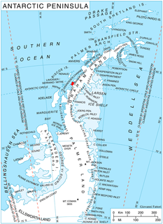
Churchill Peninsula is an ice-covered peninsula between Cabinet Inlet and Adie Inlet, extending some 30 miles (50 km) in a southeasterly direction from the east coast of Graham Land. The peninsula ends in Cape Alexander separating Oscar II Coast to the northeast from Foyn Coast to the southwest, and has its east coast indented by Zimen Inlet and Brentopara Inlet.

Posadowsky Glacier is a glacier about 9 nautical miles long, flowing north to Posadowsky Bay immediately east of Gaussberg. Posadowsky Bay is an open embayment, located just east of the West Ice Shelf and fronting on the Davis Sea in Kaiser Wilhelm II Land. Kaiser Wilhelm II Land is the part of East Antarctica lying between Cape Penck, at 87°43'E, and Cape Filchner, at 91°54'E, and is claimed by Australia as part of the Australian Antarctic Territory. Other notable geographic features in this area include Drygalski Island, located 45 mi NNE of Cape Filchner in the Davis Sea, and Mirny Station, a Russian scientific research station.

Bader Glacier is a small glacier draining the west slopes of Rudozem Heights and flowing to Bourgeois Fjord just south of Thomson Head on German Peninsula, Fallières Coast on the west side of Graham Land, Antarctica.
Barber Glacier is a glacier rising just east of Mount Bruce in the Bowers Mountains and flowing north to the coast between Stuhlinger Ice Piedmont and Rosenau Head, Victoria Land, Antarctica. The glacier was mapped by the United States Geological Survey from surveys and from U.S. Navy air photos, 1960–65, and named by the Advisory Committee on Antarctic Names for Captain Don W. Barber, CE, USA, construction and equipment officer, U.S. Naval Support Force, Antarctica, 1967 and 1968. The glacier lies on the Pennell Coast, a portion of Antarctica lying between Cape Williams and Cape Adare.

Graham Coast is the portion of the west coast of Graham Land in Antarctic Peninsula, extending 172 km between Cape Bellue to the southwest and Cape Renard to the northeast.

Borradaile Island is one of the Balleny Islands. It was the site of the first landing south of the Antarctic Circle, and features the "remarkable pinnacle" called Beale Pinnacle, near Cape Beale on its south-eastern coast, and Cape Scoresby on its north-western coast.
Graveson Glacier is a broad north-flowing tributary to the Lillie Glacier, draining that portion of the Bowers Mountains between the Posey Range and the southern part of Explorers Range, Victoria Land, Antarctica. The geographical feature is fed by several lesser tributaries and enters Lillie Glacier via Flensing Icefall. The glacier was so named by the northern party of the New Zealand Geological Survey Antarctic Expedition, 1963–64, for F. Graveson, a mining engineer who wintered at Scott Base in 1963 and was field assistant on this expedition. The glacier lies situated on the Pennell Coast, a portion of Antarctica lying between Cape Williams and Cape Adare.
Marie Island is an island 2 nautical miles (4 km) long, which lies immediately north of Cape Evensen on the northwest coast of Stresher Peninsula in Graham Land, Antarctica. The name "Pointe Marie," after the elder sister of Dr. Jean-Baptiste Charcot, was applied by the Third French Antarctic Expedition (1903–05) to a point on the coast close north of Cape Evensen. After the Fourth French Antarctic Expedition (1908–10) Charcot re-applied the name to the southern tip of an island, "Ile Waldeck-Rousseau," in approximately the same latitude. Correlating its survey with those of Charcot, the British Graham Land Expedition (1934–37) identified "Ile Waldeck-Rousseau" as Waldeck-Rousseau Peak on the mainland. The most prominent feature near the peak requiring a name is this island, and the name "Marie Island" preserves Charcot's naming in the locality.

The Lassiter Coast is the portion of the east coast of the Antarctic Peninsula that extends from Cape Mackintosh to Cape Adams. The northern portion of this coast was discovered and photographed from the air by the United States Antarctic Service in 1940. During 1947 the entire extent of the coast was photographed from the air by the Ronne Antarctic Research Expedition (RARE) under Finn Ronne, who in conjunction with the Falkland Islands Dependencies Survey charted it from the ground.

