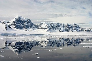
Pursuit Point is a mostly ice-covered peninsula on south-eastern Wiencke Island, one of the larger islands of the Palmer Archipelago of Antarctica. [1]
Pursuit Point is a mostly ice-covered peninsula on south-eastern Wiencke Island, one of the larger islands of the Palmer Archipelago of Antarctica. [1]
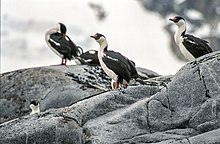
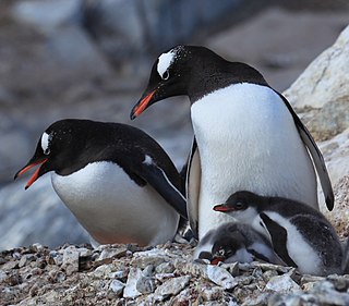
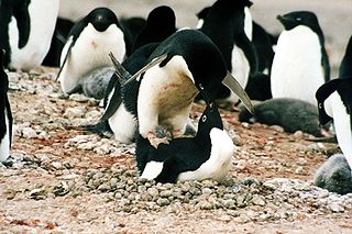
The peninsula has been identified as an Important Bird Area (IBA) by BirdLife International because it supports breeding colonies of about 200 pairs of chinstrap penguins and 140 pairs of imperial shags. [1]

Cuverville Island or Île de Cavelier de Cuverville is a dark, rocky island lying in Errera Channel between Arctowski Peninsula and the northern part of Rongé Island, off the west coast of Graham Land in Antarctica. Cuverville Island was discovered by the Belgian Antarctic Expedition (1897–1899) under Adrien de Gerlache, who named it for Jules de Cuverville (1834–1912), a vice admiral of the French Navy.
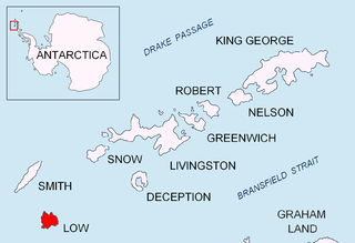
Wiencke Island is an island 26 km (16 mi) long and from 3 to 8 km wide, about 67 km2 (26 sq mi) in area, the southernmost of the major islands of the Palmer Archipelago, lying between Anvers Island to its north across the Neumayer Channel and the west coast of the Antarctic Peninsula to its east across the Gerlache Strait.
Avian Island is an island, 1.2 km (0.7 mi) long and 40 metres (130 ft) high, lying close off the south tip of Adelaide Island, Antarctica. It was discovered by the French Antarctic Expedition, 1908–10, under Jean-Baptiste Charcot, and visited in 1948 by the Falkland Islands Dependencies Survey, who so named it because of the large number and variety of birds (avians) found there.
The Duroch Islands are a group of islands and rocks which extend over an area of about 3 nautical miles, centred about 1 nautical mile off Cape Legoupil on the north coast of Trinity Peninsula, Antarctica. The islands are close to Chile's Base General Bernardo O'Higgins Riquelme at Cape Legoupil.

Byers Peninsula is a mainly ice-free peninsula forming the west end of Livingston Island in the South Shetland Islands of Antarctica. It occupies 60 km2 (23 sq mi), borders Ivanov Beach to the northeast and is separated from Rotch Dome on the east by the ridge of Urvich Wall. The peninsula features more than 60 meltwater streams and as many lakes, notably Midge Lake, Limnopolar Lake and Basalt Lake. Byers Peninsula has a regime of special environmental protection under the Antarctic Treaty System and requires a permit to enter.
Cape Wallace is the cape marking the northern extremity of Limets Peninsula and the north-west end of Low Island in the South Shetland Islands of Antarctica. Though the origin of the name Cape Wallace is unknown, it has appeared on charts for over a hundred years and its usage has been established internationally.

Watson Peninsula is a narrow peninsula 4 km (2.5 mi) long separating Macdougal and Marr Bays on the north coast of Laurie Island, in the South Orkney Islands of Antarctica. It was charted in 1903 by the Scottish National Antarctic Expedition under Bruce, who named it for G.L. Watson, yacht designer and redesigner of the expedition ship Scotia.
D'Urville Monument is a conspicuous conical summit, 575 m (1,886 ft) high, at the south-west end of Joinville Island, off the north-east end of the Antarctic Peninsula. It was discovered by a British expedition under James Clark Ross between 1839 and 1843. It was named by him for Captain Jules Dumont d'Urville.
Jameson Point is a small headland on the north side of the entrance to Malina Cove, situated 6.3 km (3.9 mi) north of Cape Garry on the west side of Low Island, in the South Shetland Islands of Antarctica. It was roughly charted by the French Antarctic Expedition, 1908–10. The point was photographed from the air by the Falkland Islands and Dependencies Aerial Survey Expedition, 1955–57, and more accurately delineated from these photos by the Falkland Islands Dependencies Survey in 1959. The name "Jameson Island" was applied to Low Island by James Weddell in 1820–23, and Jameson Point has been approved for this point to preserve Weddell's name on Low Island.
The Tupinier Islands are a group of pyramid-shaped islands lying off the north coast of Trinity Peninsula, about 6 km (3.7 mi) west of Cape Ducorps. They were discovered by the French expedition under Captain Jules Dumont d'Urville, 1837–40, and named after Baron Tupinier (1779–1850), an official of the French Naval Ministry who was instrumental in obtaining government support for the expedition. The islands were recharted by the Falkland Islands Dependencies Survey (FIDS) in 1946.
Pirie Peninsula is a narrow peninsula extending 6 km (3.7 mi) northward from the center of Laurie Island, in the South Orkney Islands of Antarctica. The peninsula was surveyed in 1903 by the Scottish National Antarctic Expedition under Bruce, who named it for Dr Harvey Pirie, surgeon and geologist of the expedition.
Potter Peninsula is a low ice-free peninsula between Potter Cove and Stranger Point in south-west King George Island, in the South Shetland Islands of Antarctica. It is protected as ASPA 132, largely because of the richness and diversity of its flora and fauna.
Paradise Harbour is a wide embayment behind Lemaire Island and Bryde Island, indenting the west coast of Graham Land, Antarctica, between Duthiers Point and Leniz Point. The name was first applied by whalers operating in the vicinity and was in use by 1920.

The Eden Rocks are two rocks lying 1.5 km off the east coast of Dundee Island, at the northern end of the Antarctic Peninsula. A small island was reported there on 30 December 1842 by Captain James Clark Ross of the Royal Navy, who named it "Eden Island" for Captain Charles Eden. Following a survey by the Falkland Islands Dependencies Survey in 1953, it was reported that the feature consists of two rocky islets rising to about 90 m in height and lying close together.

Harmony Point is a point which lies close west of Harmony Cove and forms both the south side of the entrance to Malak Sechko Cove and the western extremity of Guangzhou Peninsula and Nelson Island, in the South Shetland Islands of Antarctica. It was charted in 1935 by Discovery Investigations personnel on the Discovery II, and named from association with Harmony Cove.
Point Martin is a point on the east side of Mossman Peninsula, 1.5 km (0.93 mi) north-west of Cape Murdoch, on the south coast of Laurie Island in the South Orkney Islands of Antarctica. It was charted in 1903 by the Scottish National Antarctic Expedition under Bruce, who named it for J. Martin, an able seaman on the expedition ship Scotia.

The James Ross Island group is a group of islands located close to the northeastern tip of the Antarctic Peninsula. The largest islands in the group are James Ross Island, Snow Hill Island, Vega Island, and Seymour Island. The islands lie to the south of the Joinville Island group. The groups contains several scientific bases, notably Marambio Base, and numerous important palaeontological sites.

The Cierva Point and offshore islands Important Bird Area is a 6540 ha tract of land and sea on the Danco Coast of the Antarctic Peninsula.
Penguin Point lies on the south-eastern coast of Seymour Island, in the James Ross Island group, near the north-eastern extremity of the Antarctic Peninsula. The Argentine Marambio Base is about 8 km to the north-east. A ridge of exposed dark rock named Blackrock Ridge runs west-southwest–east-northeast, 1.5 nautical miles north of Penguin Point.
64°55′S63°27′W / 64.917°S 63.450°W
| | This Palmer Archipelago location article is a stub. You can help Wikipedia by expanding it. |