Related Research Articles
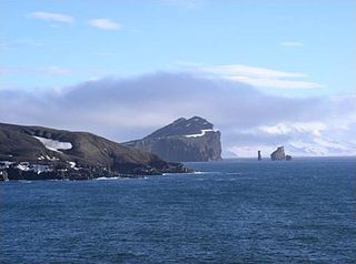
Deception Island is an island in the South Shetland Islands close to the Antarctic Peninsula with a large and usually "safe" natural harbor, which is occasionally troubled by the underlying active volcano. This island is the caldera of an active volcano, which seriously damaged local scientific stations in 1967 and 1969. The island previously held a whaling station it is now the most popular tourist destination with over 15,000 visitors per year. Two research stations are operated by Argentina and Spain during the summer season. While various countries have asserted sovereignty, it is still administered under the Antarctic Treaty System.

Hope Bay on Trinity Peninsula, is five kilometres long and three kilometres wide, indenting the tip of the Antarctic Peninsula and opening on Antarctic Sound. It is the site of the Argentinian Antarctic settlement Esperanza Base, established in 1952.
Argentine Antarctica is an area of Antarctica claimed by Argentina as part of its national territory. It consists of the Antarctic Peninsula and a triangular section extending to the South Pole, delimited by the 25° West and 74° West meridians and the 60° South parallel. This region overlaps the British and Chilean claims in Antarctica. Argentina's Antarctic claim is based on its continued presence in the region since 1904, and the area's proximity to the South American continent. Argentina's claim to this area is subject to the Antarctic Treaty. Administratively, Argentine Antarctica is a department of the province of Tierra del Fuego, Antarctica, and South Atlantic Islands. The provincial authorities are based in Ushuaia. Despite the claim to this Antarctic area, Argentinean authority extends no further than the nation's bases. The Argentine exploration of the continent started early in the 20th century. José María Sobral was the first Argentine to set foot on Antarctica, in 1902, where he spent two seasons with the Swedish Antarctic Expedition of Otto Nordenskiöld. Shortly afterward, in 1904, the Orcadas permanent base was already fully operational. Years later other bases would be created, some permanent and others seasonal. The first Argentine expedition to reach the South Pole was the 1965 Operación 90.

Cape Shirreff is a prominent cape at the north end of the rocky peninsula which separates Hero Bay and Barclay Bay on the north coast of Livingston Island, in the South Shetland Islands of Antarctica. The cape was named by Edward Bransfield in 1820 after Captain William H. Shirreff, the British commanding officer in the Pacific at that time.

Yankee Harbour is a small inner harbour entered from Shopski Cove between Glacier Bluff and Spit Point, indenting the south-west side of Greenwich Island in the South Shetland Islands, Antarctica. It is 2.35 km (1.46 mi) long in west-south-west to east-north-east direction, and 1.6 km (0.99 mi) wide, and is bounded by Provadiya Hook to the south-west, Parvomay Neck to the north and east, and Kladara Beach to the south.

Barnard Point is a headland which marks the south-east side of the entrance to False Bay on the south side of Livingston Island in the South Shetland Islands, Antarctica. It is situated on Rozhen Peninsula, 1.5 km (1 mi) north-north-west of Botev Point and 6.6 km (4 mi) south-east of Miers Bluff.

Cheal Point is a rocky headland 2 km (1.2 mi) east-south-east of Return Point, the south-western extremity of Coronation Island, in the South Orkney Islands of Antarctica.

Christoffersen Island is a small island immediately west of the southern end of Powell Island in the South Orkney Islands of Antarctica. The name appears on a chart by Norwegian whaling captain Petter Sorlle, who made a running survey of these islands in 1912–13.
Stonethrow Ridge is a snow-covered ridge rising west of Fumarole Bay on Deception Island, in the South Shetland Islands of Antarctica. Vapour Col lies to the south of the ridge.
Grey Island is 1 km (0.62 mi) south of Michelsen Island and 2 km (1.2 mi) west of the southern part of Fredriksen Island, in the South Orkney Islands of Antarctica. It was first charted and named Holmen Graa on a map by the Norwegian whaler Captain Petter Sorlle, who made a running survey of the South Orkney Islands in 1912–13. The anglicised form appears on the chart by Discovery Investigations personnel on the Discovery II who surveyed the islands in 1933.
Ferrier Peninsula is a narrow peninsula, 2.4 km (1.5 mi) long, forming the eastern end of Laurie Island in the South Orkney Islands of Antarctica. It was roughly charted in 1823 by a British sealing expedition under James Weddell. It was surveyed in 1903 by the Scottish National Antarctic Expedition under William Speirs Bruce, who named it for his secretary J.G. Ferrier, who was also manager in Scotland of the expedition.
Fredriksen Island is an island 5 km (3.1 mi) long and 1 km (0.62 mi) wide, lying 1 km south-east of Powell Island in the South Orkney Islands of Antarctica. It was discovered by Captains Nathaniel Palmer and George Powell in the course of their joint cruise in December 1821. It was named by Norwegian whaling captain Petter Sorlle, who made a running survey of the island in the 1912–13 summer.
Graptolite Island is an island 0.8 km (0.50 mi) long in the north-east part of Fitchie Bay, lying off the south-east portion of Laurie Island in the South Orkney Islands of Antarctica. James Weddell's chart published in 1825 shows two islands in essentially this position. Existence of a single island was determined in 1903 by the Scottish National Antarctic Expedition under William Speirs Bruce, who so named it because what were thought to be graptolite fossils were found there. Later analysis showed that the fossils on Graptolite Island were merely the remains of ancient plants.
Michelsen Island is a small island in the South Orkney Islands off Antarctica. It is joined to the southern end of Powell Island by a narrow isthmus of occasionally submerged boulders. The island was first observed and roughly mapped in 1821 by Captains George Powell and Nathaniel Palmer. It was named on a map by Captain Petter Sørlle, a Norwegian whaler who made a running survey of the South Orkney Islands in 1912–13.

Harmony Point is a point which lies close west of Harmony Cove and forms both the south side of the entrance to Malak Sechko Cove and the western extremity of Guangzhou Peninsula and Nelson Island, in the South Shetland Islands of Antarctica. It was charted in 1935 by Discovery Investigations personnel on the Discovery II, and named from association with Harmony Cove.
Crater Lake is a volcanic crater, now filled with water, lying north-west of Mount Kirkwood on the south side of Deception Island, in the South Shetland Islands of Antarctica. The descriptive name was given by the United Kingdom Antarctic Place-Names Committee (UK-APC) in 1959.
Ronald Hill is a rocky, ice-free hill, 105 m in height, standing north of Kroner Lake on Deception Island, in the South Shetland Islands of Antarctica. It was charted, photographed and named by Olaf Holtedahl of the Norwegian expedition 1927–28, after the floating factory SS Ronald, which belonged to the Hektor Whaling Company. and was anchored at Deception Island in 1911-12 and many later seasons.
South East Point is a point 1.9 km (1.2 mi) east-north-east of Fildes Point, marking the south-eastern point of Deception Island, in the South Shetland Islands of Antarctica. It was charted by a British expedition 1828–31, under Henry Foster. The name was proposed in 1949 by the Hydrographic Department of the Admiralty, following a survey of the island by Lieutenant Commander D.N. Penfold, Royal Navy, in 1948–49.

Baily Head is a prominent headland, 160 m high, forming the easternmost extremity of Deception Island, in the South Shetland Islands of Antarctica.

Fumarole Bay is a bay on the southwest side of Port Foster in the interior of Deception Island, in the South Shetland Islands. Having a similar name in the same island is the Vapour Col.
References
- ↑ Vapour Col: Antarctica. National Geospatial-Intelligence Agency, Bethesda, MD, USA. 2012. [2019-01-07].
- ↑ "Vapour Col". BirdLife data zone: Important Bird Areas. BirdLife International. 2013. Retrieved 22 January 2013.
![]() This article incorporates public domain material from the United States Geological Survey document: "Vapour Col".(content from the Geographic Names Information System )
This article incorporates public domain material from the United States Geological Survey document: "Vapour Col".(content from the Geographic Names Information System )
Coordinates: 62°59′S60°44′W / 62.983°S 60.733°W
| | This Deception Island location article is a stub. You can help Wikipedia by expanding it. |