

The Donskiye Islands form a small archipelago, including Warriner Island and Redfearn Island, off Breidnes Peninsula in the Vestfold Hills of Princess Elizabeth Land, Antarctica.
The Donskiye Islands form a small archipelago, including Warriner Island and Redfearn Island, off Breidnes Peninsula in the Vestfold Hills of Princess Elizabeth Land, Antarctica.
The islands were mapped from aerial photographs taken by the Lars Christensen Expedition (1936–37) and called Mulvikholmane (Mule Bay Islets) by Norwegian cartographers. They were photographed by the USN’s Operation Highjump in 1946–47, the Soviet Antarctic Expedition in 1956, and ANARE in 1957 and 1958. They were named Ostrova Donskiye (Don Islands) by the Soviet Expedition. [1]
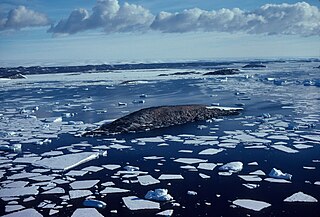
A 20 ha site, comprising a small unnamed island situated 500 m west of Redfearn Island in the Donskiye group, has been designated an Important Bird Area (IBA) by BirdLife International because it supports a breeding colony of about 21,000 pairs of Adélie penguins, estimated from 2012 satellite imagery. The nearest permanent research station is Australia's Davis, 6 km to the north-east on Breidnes Peninsula. [2]

The West Ice Shelf is a prominent ice shelf extending about 350 km (220 mi) in an east-west direction along the Leopold and Astrid Coast in East Antarctica between Barrier Bay and Posadowsky Bay, and up to 120 km northwards from the continental margin.

Stonington Island is a rocky island lying 1.8 km (1.1 mi) northeast of Neny Island in the eastern part of Marguerite Bay off the west coast of Graham Land, Antarctica. It is 0.75 km (0.47 mi) long from north-west to south-east and 0.37 km (0.23 mi) wide, yielding an area of 20 ha. It was formerly connected by a drifted snow slope to Northeast Glacier on the mainland. Highest elevation is Anemometer Hill which rises to 25 m (82 ft).

Clark Peninsula is a rocky peninsula, about 3 km (2 mi) long and wide, lying 5 km (3 mi) north-east of Australia's Casey Station at the north side of Newcomb Bay on the Budd Coast of Wilkes Land in Antarctica.
The Tryne Islands are a group of numerous small Antarctic islands and rocks, about 7 km (4 mi) in extent, forming the western limit of Tryne Bay and Tryne Sound at the north-eastern end of the Vestfold Hills. The islands were mapped by Norwegian cartographers from aerial photographs taken by the Lars Christensen Expedition (1936–37) and named Trynøyane.

Andersen Island is an island 7 kilometres (4 nmi) west of Thorgaut Island, and 4 kilometres (2 nmi) east of Child Rocks, in the Robinson Group, Antarctica. It was mapped by the British Australian New Zealand Antarctic Research Expedition under Douglas Mawson in February 1931. The island was also charted from the whaler Thorgaut about the same time. It was named after Captain Lars Andersen of the whaler Falk who had assisted the Discovery with coal.
Warriner Island is a small ice-free island in the Donskiye Islands group lying just off the west end of Breidnes Peninsula in the Vestfold Hills, off the coast of East Antarctica. It is 1.2 km long by 0.7 km wide, reaching an elevation of 52 m.
Turner Island is an island in the Donskiye Islands group lying 0.9 km (0.6 mi) north-west of Bluff Island and 4.6 km (2.9 mi) west of Breidnes Peninsula, Vestfold Hills, in Prydz Bay, Princess Elizabeth Land, Antarctica.
Trigwell Island is an island in Prydz Bay, lying immediately west of Flutter Island and 1 nautical mile (1.9 km) west of Breidnes Peninsula, Vestfold Hills. First mapped from air photos taken by the Lars Christensen Expedition, 1936–37. Remapped by ANARE (1957–58) and named for E.S. Trigwell, radio supervisor at Davis Station in 1958.
Filla Island is a rocky island about 5.5 kilometres (3.4 mi) long, located in the northern part of the Rauer Islands and being the largest island in the group. It was charted by Norwegian cartographers from air photos taken by the Lars Christensen Expedition (1936–37). They gave the name Filla to a larger island here, presumably for the ragged outline of the feature as shown on the Norwegian chart. In 1952, John Roscoe made a study of this area as revealed in aerial photographs taken by U.S. Navy Operation Highjump (1946–47). He found that what the Norwegians had named Filla was in fact a cluster of small islands. He applied the name Filla Island to the largest of these as described.
Heidemann Bay is a bay, 1 nautical mile (2 km) long, indenting the seaward end of Breidnes Peninsula in the Vestfold Hills of Antarctica, just south of Davis Station. It was mapped by Norwegian cartographers from air photos taken by the Lars Christensen Expedition, 1936–37. The bay was first visited by an Australian National Antarctic Research Expeditions party from the Kista Dan on January 11, 1957, and was named for Frank Heidemann, second mate of the Kista Dan. Heidemann Bay which was gouged by glaciers is flanked by two small peninsulas which rise approximately 20 metres above sea level. Heidemann Bay is an extension of Heidemann Valley which runs in the same compass direction for a further two kilometres. Heidemann Valley is of uniform elevation and relatively flat but covered in a large number of moraine rocks and boulders.
Macklin Island is a small island in the eastern part of the Robinson Group, about 3 kilometres (1.5 nmi) north of Kirton Island, and 6 kilometres (3 nmi) northwest of Cape Daly, Mac. Robertson Land, Antarctica. It was mapped by Norwegian cartographers from air photos taken by the Lars Christensen Expedition, 1936–37, and was named by the Antarctic Names Committee of Australia for E.L. Macklin, a radio officer at Mawson Station in 1955 and 1959.
Kartografov Island is a small coastal island lying in the western part of the mouth of Harald Bay, Oates Land, Antarctica. It was photographed by U.S. Navy Operation Highjump (1946–47), the Soviet Antarctic Expedition (1957–58) and the Australian National Antarctic Research Expedition (1959). The island was named "Ostrov Kartografov" by the Soviet expedition.
Redfearn Island is a small island in the Donskiye Islands group lying just west of Warriner Island and 1 nautical mile (1.9 km) off the west end of Breidnes Peninsula, Vestfold Hills. First plotted as two small islands by Norwegian cartographers working from air photos taken by the Lars Christensen Expedition, 1936–37. Replotted as a single island from ANARE air photos of 1957–58. Named by Antarctic Names Committee of Australia (ANCA) for H.T. Redfearn, diesel mechanic at Davis Station, 1961.
Lugg Island is a small island in the Donskiye Islands group lying 2 km (1.2 mi) north-west of Lake Island, off the west end of Breidnes Peninsula, Vestfold Hills, Antarctica. It was first plotted from aerial photos taken by the Lars Christensen Expedition, 1936–37, and was named by the Antarctic Names Committee of Australia for Dr. D. Lugg, medical officer at Davis Station in 1963, who visited the island for biological studies.
Bluff Island is an island lying 1 kilometre (0.5 nmi) south of Magnetic Island and 4 kilometres (2 nmi) west of the Breidnes Peninsula, Vestfold Hills, in Prydz Bay, Antarctica. It was mapped from aerial photos taken by the Lars Christensen Expedition, 1936–37, re-emapped by the Australian National Antarctic Research Expeditions (1957–58) and so named because the south end of the island is marked by a steep cliff face.
Cameron Island is a small island just north of Hailstorm Island, in the Swain Islands, Antarctica. This region was photographed from the air by U.S. Navy Operation Highjump (1946–47), ANARE (1956), and the Soviet expedition (1956). The island was included in a 1957 ground survey by C.R. Eklund, who named it for Richard L. Cameron, chief glaciologist at Wilkes Station, 1957.

Amanda Bay, also sometimes known as Hovde Cove, lies in southern Prydz Bay on the Ingrid Christensen Coast of Princess Elizabeth Land, East Antarctica. It is best known for its breeding colony of several thousand pairs of emperor penguins on sea ice at the south-west corner of the bay.
Magnetic Island is a small island in the Donskiye Islands group in the Donskiye Islands group lying 500 m north-east of Turner Island, off the Breidnes Peninsula, Vestfold Hills, Princess Elizabeth Land, Antarctica.
Kazak Island lies 1 km south of Hawker Island and 0.5 km west of the Mule Peninsula, in Prydz Bay on the Ingrid Christensen Coast of Princess Elizabeth Land, Antarctica. The nearest permanent research station is Australia's Davis, some 10 km to the north-east on Broad Peninsula, Vestfold Hills.

Zolotov Island lies 1 km south of Hawker Island and 0.5 km west of the Mule Peninsula, in Prydz Bay on the Ingrid Christensen Coast of Princess Elizabeth Land, Antarctica. The nearest permanent research station is Australia's Davis, some 10 km to the north-east on Broad Peninsula, Vestfold Hills. Several small lakes are present on the island.
Coordinates: 68°36′29″S77°53′37″E / 68.60806°S 77.89361°E
| | This Princess Elizabeth Land location article is a stub. You can help Wikipedia by expanding it. |