

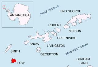
Cape Bowles is a cape forming the southern extremity of Clarence Island in the South Shetland Islands of Antarctica. It was named in 1820 by Edward Bransfield, Master, Royal Navy, while exploring the islands in the brig Williams.
Cape Bowles is a cape forming the southern extremity of Clarence Island in the South Shetland Islands of Antarctica. It was named in 1820 by Edward Bransfield, Master, Royal Navy, while exploring the islands in the brig Williams.
The site has been identified as an Important Bird Area (IBA) by BirdLife International because it supports a very large breeding colony of over 100,000 pairs of chinstrap penguins. [1]

Beauchene Island is the southernmost of the Falkland Islands, lying about 54 kilometres (34 mi) south of Porpoise Point in Lafonia. It was discovered in 1701 by Jacques Gouin de Beauchêne, after whom it was named.

Cape Lookout, also known as Cabo Fossatti or Cabo Vigia, is a steep cape, 240 m high, marking the southern extremity of Elephant Island in the South Shetland Islands of Antarctica. The name Cape Lookout appears on a map of 1822 by Captain George Powell, a British sealer, and is now established in international usage.
Cape Hooker is the south-eastern point of Low Island, in the South Shetland Islands of Antarctica. The feature was roughly charted by nineteenth century sealers; it was further charted by Commander Henry Foster in 1829 but shown as the north-eastern point of the island. Following air photography by the Falkland Islands and Dependencies Aerial Survey Expedition in 1956, the charted shape of the island was drastically altered and the name Cape Hooker was applied to its south-eastern point as originally described.

Aspland Island is a small island 7.4 km (4 nmi) west of Gibbs Island in the South Shetland Islands of Antarctica. The name dates back to at least 1821.

Chinstrap Cove is a cove 6 km (3.7 mi) north-east of Escarpada Point on the north-west coast of Clarence Island, South Shetland Islands, Antarctica entered northeast of Vaglen Point. The cove has been identified as an Important Bird Area (IBA) by BirdLife International because it supports a large breeding colony of about 20,000 pairs of chinstrap penguins, after which it was named by the UK Joint Services Expedition which visited the site in 1970–1971. The 74 ha IBA includes the ice-free area south of the cove, extending 2 km along the coast.

Cape Wadworth is the northern extremity of Coulman Island, in the Ross Sea just off Victoria Land. Discovered 17 January 1841 by Sir James Clark Ross who named it to compliment his wife's uncle, Robert John Coulman of Wadworth Hall, Doncaster.

Walker Point is a point on the southwest side of the entrance to Gurkovska Cove which lies 6 km (3.7 mi) south-west of Cape Valentine, near the eastern end of Elephant Island in the South Shetland Islands of Antarctica. The name appears on Powell's map of 1822 based upon the joint cruise of Captain Nathaniel B. Palmer, in the sloop James Monroe with Captain George Powell, in the sloop Dove, in December 1821. It was probably named for Captain John Walker, whose assistance in the construction of the map was acknowledged by Powell.
Cape Wallace is the cape marking the northern extremity of Limets Peninsula and the north-west end of Low Island in the South Shetland Islands of Antarctica. Though the origin of the name Cape Wallace is unknown, it has appeared on charts for over a hundred years and its usage has been established internationally.

Cape Whitson, is a headland on the south coast of Laurie Island, the easternmost and second largest of the South Orkney Islands of Antarctica. It lies about 9 km south-east of Argentina’s Orcadas Base.

Escarpada Point, also known as Craggy Point, is the rocky, rugged south-west point of Clarence Island in the South Shetland Islands of Antarctica. The descriptive name was given in the course of Argentine government visits in 1953–1954.
False Round Point is a point 16 km (9.9 mi) west of North Foreland and 4 km (2.5 mi) south of Ridley Island, on the north coast of King George Island in the South Shetland Islands of Antarctica. The point has appeared on charts since about 1822. It was probably named for its similarity to Round Point, which lies 22 km (14 mi) to the west, by Discovery Investigations personnel on the Discovery II who charted the north coast of this island in 1937.
Cape Garry is a cape forming the south-western extremity of Low Island in the South Shetland Islands of Antarctica. It was charted and named by a British expedition under Henry Foster, 1828–31, and was more accurately mapped by the Falkland Islands Dependencies Survey in 1959 from aerial photographs taken by the Falkland Islands and Dependencies Aerial Survey Expedition, 1955–57.
Cape Hansen is a cape which separates Marshall Bay and Iceberg Bay on the south coast of Coronation Island, in the South Orkney Islands, Antarctica. The name appears on a chart based upon a running survey of the islands in 1912–13 by Petter Sørlle, a Norwegian whaling captain.
Cape Melville, is a low-lying, ice-free headland at the eastern end of King George Island in the South Shetland Islands of Antarctica. Some 388 ha of the site has been identified as an Important Bird Area (IBA) by BirdLife International because it supports a large breeding colony of about 16,000 pairs of chinstrap penguins.

The Cierva Point and offshore islands Important Bird Area is a 6540 ha tract of land and sea on the Danco Coast of the Antarctic Peninsula.
East of Nelly Point Important Bird Area is a 35 ha, ice-free tract of land on the south-eastern coast of Elephant Island, in the South Shetland Islands of Antarctica. It is a small, unnamed headland, some 2.5 km east of Nelly Point, which has been referred to unofficially as Chinstrap Camp. The site has been identified as an Important Bird Area (IBA) by BirdLife International because it supports a large breeding colony of about 24,000 pairs of chinstrap penguins.
Saddleback Point is a headland on the northern coast of Elephant Island, in the South Shetland Islands of Antarctica. The site lies 2 km (1.2 mi) to the west of Point Wild.

Fur Seal Point, sometimes referred to as Fur Seal Beach, is a cape midway along the eastern coast of Clarence Island, the easternmost of the South Shetland Islands of Antarctica. Just off the headland lies the small Sugarloaf Island.
Milosz Point is a low-lying, ice-free cape on the northern coast of King George Island, the largest of the South Shetland Islands of Antarctica. It lies 4.5 km west of North Foreland at the eastern entrance to Venus Bay and the western entrance to Emerald Cove. It, along with neighbouring Czeslaw Point, has been identified as an Important Bird Area (IBA) by BirdLife International because it supports a large breeding colony of about 17,000 pairs of chinstrap penguins.
Sugarloaf Island is a conspicuous small island which lies close to the east side of Clarence Island, midway between Cape Lloyd and Cape Bowles, in the South Shetland Islands, Antarctica. It lies 3.2 km north of Lebed Point, on the northern side of the entrance to Istros Bay. The name was in use by American and British sealers as early as 1822 and is now well established.
Coordinates: 61°19′S54°6′W / 61.317°S 54.100°W
| This Clarence Island (South Shetland Islands) location article is a stub. You can help Wikipedia by expanding it. |