Duclos-Guyot Bluff

Last updated
Location of Clarence Island in the South Shetland Islands. South Shetland Islands Map.png
Location of Clarence Island in the South Shetland Islands.
Clarence Island seen from northeast with (left to right) Cape Bowles; Dobrodan Glacier and Highton Glacier surmounted by Duclos-Guyot Bluff and Mount Irving; Treskavets Glacier, Orcho Glacier and Banari Glacier surmounted by Ravelin Ridge; and Cape Lloyd. Clarence Island, Antarctica (6018808983).jpg
Clarence Island seen from northeast with (left to right) Cape Bowles; Dobrodan Glacier and Highton Glacier surmounted by Duclos-Guyot Bluff and Mount Irving; Treskavets Glacier, Orcho Glacier and Banari Glacier surmounted by Ravelin Ridge; and Cape Lloyd.

Duclos-Guyot Bluff (Bulgarian : връх Дюкло Гийо, ‘Vrah Duclos-Guyot’ \'vrah dyu-'klo gi-'yo\) is the ice-covered peak rising to 1800 m at the south extremity of Urda Ridge on Clarence Island in the South Shetland Islands, Antarctica. It has precipitous and partly ice-free south slopes, and surmounts Skaplizo Glacier to the west and Dobrodan Glacier to the northeast.

Bulgarian language South Slavic language

Bulgarian, is an Indo-European language and a member of the Southern branch of the Slavic language family.

Urda Ridge

Urda Ridge is the mostly ice-covered ridge occupying the interior of southern Clarence Island in the South Shetland Islands, Antarctica. It extends 8 km in north-northeast to south-southwest direction and 9 km in west-northwest to east-southeast direction, rising to 1950 m at the island’s summit Mount Irving, and is connected to Ravelin Ridge to the north by Soyka Saddle. The southeast slopes of the feature are drained by Dobrodan and Highton Glaciers, and its northwest slopes — by Skaplizo, Giridava and Bersame Glaciers. Urda is a Thracian place name from Southern Bulgaria.

Clarence Island (South Shetland Islands) island of the South Shetland Islands

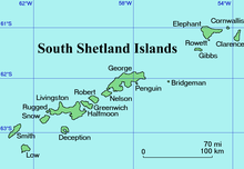
Clarence Island is 21.46 km (13.3 mi) long in south-southwest to north-northeast direction and the easternmost of the South Shetland Islands of Antarctica. The name dates back to at least 1821 and is now established in international usage. Ernest Shackleton saw Clarence Island on his famous boat voyage but landed on Elephant Island. It is claimed by Argentina as part of Argentine Antarctica, by Britain as part of the British Antarctic Territory, and by Chile as part of the Chilean Antarctic Territory.

Contents

The peak is named after the French mariner Nicolas Pierre Duclos-Guyot (1722-1794), second in command under Louis Antoine de Bougainville in the first French circumnavigation of the world, who sailed in Antarctic waters on board the Spanish ship León in 1756.

The French are an ethnic group and nation who are identified with the country of France. This connection may be ethnic, legal, historical, or cultural.

Louis Antoine de Bougainville French admiral and explorer

Louis-Antoine, Comte de Bougainville was a French admiral and explorer. A contemporary of the British explorer James Cook, he took part in the Seven Years' War in North America and the American Revolutionary War against Britain. Bougainville later gained fame for his expeditions, including circumnavigation of the globe in a scientific expedition in 1763, the first recorded settlement on the Falkland Islands, and voyages into the Pacific Ocean. Bougainville Island of Papua New Guinea as well as the Bougainvillea flower were named after him.

Antarctic region around the Earths South Pole

The Antarctic is a polar region around the Earth's South Pole, opposite the Arctic region around the North Pole. The Antarctic comprises the continent of Antarctica, the Kerguelen Plateau and other island territories located on the Antarctic Plate or south of the Antarctic Convergence. The Antarctic region includes the ice shelves, waters, and all the island territories in the Southern Ocean situated south of the Antarctic Convergence, a zone approximately 32 to 48 km wide varying in latitude seasonally. The region covers some 20 percent of the Southern Hemisphere, of which 5.5 percent is the surface area of the Antarctic continent itself. All of the land and ice shelves south of 60°S latitude are administered under the Antarctic Treaty System. Biogeographically, the Antarctic ecozone is one of eight ecozones of the Earth's land surface.

Location

Duclos-Guyot Bluff is located at 61°17′58″S54°07′28″W / 61.29944°S 54.12444°W / -61.29944; -54.12444 Coordinates: 61°17′58″S54°07′28″W / 61.29944°S 54.12444°W / -61.29944; -54.12444 , which is 2.9 km northwest of Cape Bowles, 5.6 km east of Craggy Point and 2.4 km south of Mount Irving. British mapping in 1972 and 2009.

Geographic coordinate system Coordinate system

A geographic coordinate system is a coordinate system that enables every location on Earth to be specified by a set of numbers, letters or symbols. The coordinates are often chosen such that one of the numbers represents a vertical position and two or three of the numbers represent a horizontal position; alternatively, a geographic position may be expressed in a combined three-dimensional Cartesian vector. A common choice of coordinates is latitude, longitude and elevation. To specify a location on a plane requires a map projection.

Cape Bowles

Cape Bowles is a cape forming the southern extremity of Clarence Island in the South Shetland Islands of Antarctica. It was named in 1820 by Edward Bransfield, Master, Royal Navy, while exploring the islands in the brig Williams.

Mount Irving mountain in Clarence Island, South Shetland Islands, Antarctica

Mount Irving is a mountain rising to ca. 1,950 metres (6,398 ft) that is the dominant elevation on Clarence Island, in the South Shetland Islands. The rounded, heavily glaciated mountain is situated in Urda Ridge occupying the southern part of the island. A prominent feature, the mountain doubtless was known to sealers in the area in the 1820s. It was named by United Kingdom Antarctic Place-Names Committee (UK-APC) for Rear Admiral Sir Edmund George Irving, Royal Navy, Hydrographer of the Navy, 1960-66. First ascent by a team comprising Capt. Crispin Agnew, John Hult and George Bruce of the Joint Services Expedition to Elephant Island on 6 December 1970.

Maps

Related Research Articles

Montana Bluff

Montana Bluff is an ice-covered peak rising to 670 m at the end of a side ridge running south-southeast from Ticha Peak in central Bowles Ridge, Livingston Island. Surmounting Perunika Glacier to the west and southwest, and Huron Glacier to the east and southeast. It is named after the city of Montana in Northwestern Bulgaria.

Razgrad Peak mountain in Greenwich Island, South Shetland Islands, Antarctica

Razgrad Peak is an ice-covered peak rising to 550 m in Breznik Heights, Greenwich Island, Antarctica. The peak is located 740 m southeast of Terter Peak, 1.7 km southwest of Momchil Peak, 2.7 km west of the summit of Viskyar Ridge, and 1.51 km north-northeast of the coastal point formed by Ephraim Bluff. An eastern offshoot of the peak is forming Maystora Peak. Surmounting Zheravna Glacier to the east and Wulfila Glacier to the west.

Serdica Peak

Serdica Peak rises to approximately 1,200m in Levski Ridge, Tangra Mountains, Livingston Island in the South Shetland Islands, Antarctica. Linked to Silistra Knoll to the west-southwest by Kotel Gap. Surmounting Macy Glacier to the west, Boyana Glacier to the southwest, and Srebarna Glacier to the southeast.

Sliven Peak mountain in Livingston Island, South Shetland Islands, Antarctica

Sliven Peak rises to 530 m in the east extremity of Melnik Ridge, Livingston Island in the South Shetland Islands, Antarctica. The peak has precipitous rocky southern slopes and partly ice-free northern slopes, overlooking Kaliakra Glacier to the northwest and Struma Glacier to the south and east.

St. Cyril Peak

St. Cyril Peak rises to 1,505m in Friesland Ridge in Tangra Mountains on Livingston Island in the South Shetland Islands, Antarctica. The peak is linked to St. Methodius Peak to the southwest by Vladaya Saddle and surmounts Ruen Icefall to the west, Macy Glacier to the east and Prespa Glacier to the south.

Terter Peak mountain in Greenwich Island, South Shetland Islands, Antarctica

Terter Peak is an ice-covered peak rising to 570 m in Breznik Heights, Greenwich Island in the South Shetland Islands, Antarctica surmounting Wulfila Glacier to the southwest, Solis Glacier to the northwest and Zheravna Glacier to the southeast.

Wulfila Glacier glacier in Antarctica

Wulfila Glacier is located on the southern slopes of Breznik Heights, Greenwich Island in the South Shetland Islands, Antarctica, south-southwest of Solis Glacier and west of Zheravna Glacier. It is bounded by Oborishte Ridge to the northwest, Nevlya Peak to the north, Terter Peak and Razgrad Peak to the northeast, and Ephraim Bluff to the southeast. The glacier extends 3 km in northwest-southeast direction and 2 km in northeast-southwest direction, draining southwestwards into McFarlane Strait between Ephraim Bluff and the base of Provadiya Hook.

Yavorov Peak

Yavorov Peak is an ice-covered peak of elevation 640 m in the Delchev Ridge of the Tangra Mountains on eastern Livingston Island in the South Shetland Islands, Antarctica. The peak surmounts Sopot Ice Piedmont to the north and west, and Strandzha Glacier to the southeast. The feature was named after the famous Bulgarian poet Peyo Yavorov (1878–1914).

Neofit Peak mountain in Smith Island, South Shetland Islands, Antarctica

Neofit Peak is an ice-covered peak rising to 1750 m in Imeon Range on Smith Island in the South Shetland Islands, Antarctica. Situated 1.12 km south-southwest of Slaveykov Peak, 3.1 km southwest of the summit Mount Foster, 2.38 km northeast of Riggs Peak and 10.98 km northeast of Cape James. Overlooking Gramada Glacier to the south, and Armira Glacier to the east and southeast. Bulgarian early mapping in 2009. Named after the Bulgarian monk, scholar and artist Neofit Rilski (1793–1881) who translated the Bible into modern Bulgarian language.

Soyka Saddle

Soyka Saddle is the ice-covered saddle of elevation 1250 m connecting Ravelin Ridge and Urda Ridge on Clarence Island in the South Shetland Islands, Antarctica. It is situated between Mount Llana on the southwest and Jerez Peak on the north-northeast, and surmounts Highton Glacier to the east.

Skaplizo Glacier

Skaplizo Glacier is 2 nautical miles long and 0.8 nautical miles wide glacier on the west side of Urda Ridge on Clarence Island in the South Shetland Islands, Antarctica situated south of Giridava Glacier. It drains the slopes of Mount Irving and Duclos-Guyot Bluff, flows west-northwestwards and enters the Southern Ocean northeast of Chichil Point.

Dobrodan Glacier

Dobrodan Glacier is the 3.4 km long and 1.2 km wide glacier on the east side of Urda Ridge on Clarence Island in the South Shetland Islands, Antarctica situated south of Highton Glacier. It drains the slopes of Mount Irving and Duclos-Guyot Bluff, flows northeastwards and enters the Southern Ocean south of Lebed Point.

Giridava Glacier

Giridava Glacier is 1.5 nautical miles long and 0.6 nautical miles wide glacier on the west side of Urda Ridge on Clarence Island in the South Shetland Islands, Antarctica situated north of Skaplizo Glacier and southwest of Bersame Glacier. It drains the slopes of Mount Irving, flows northwestwards and enters Chinstrap Cove east of Vaglen Point.

Mount Llana

Mount Llana is the ice-covered peak rising to 1300 m at the north extremity of Urda Ridge on Clarence Island in the South Shetland Islands, Antarctica. It is connected to Jerez Peak by Soyka Saddle, and surmounts Bersame Glacier to the west and Highton Glacier to the east.

Bersame Glacier

Bersame Glacier is the 2.4 km long and 1.5 km wide glacier on the west side of Urda Ridge on Clarence Island in the South Shetland Islands, Antarctica situated northeast of Giridava Glacier. It drains the slopes of Mount Llana, flows northwestwards and enters the Southern Ocean northeast of the terminus of Giridava Glacier.

Jerez Peak

Jerez Peak is the ice-covered peak rising to 1400 m at the south extremity of Ravelin Ridge on Clarence Island in the South Shetland Islands, Antarctica. It is connected to Mount Llana by Soyka Saddle, and surmounts Treskavets Glacier to the northeast and Highton Glacier to the southeast.

Treskavets Glacier

Treskavets Glacier is 1.3 nautical miles long and 0.8 nautical miles wide glacier on the east side of Ravelin Ridge on Clarence Island in the South Shetland Islands, Antarctica situated north of Highton Glacier and south of Orcho Glacier. It drains the slopes of Jerez Peak, flows northeastwards and enters the Southern Ocean south of Gesha Point.

Orcho Glacier

Orcho Glacier is 1.1 nautical miles long and 1 nautical mile wide glacier on the east side of Ravelin Ridge on Clarence Island in the South Shetland Islands, Antarctica situated north of Treskavets Glacier and south-southwest of Banari Glacier. It flows eastwards and enters the Southern Ocean north of Gesha Point.

Banari Glacier

Banari Glacier is the 1 nautical mile long and 0.6 nautical miles wide glacier on the east side of Ravelin Ridge on Clarence Island in the South Shetland Islands, Antarctica situated north-northeast of Orcho Glacier. It flows northeastwards and enters Smith Cove.

References

Antarctic Place-names Commission

The Antarctic Place-names Commission was established by the Bulgarian Antarctic Institute in 1994, and since 2001 has been a body affiliated with the Ministry of Foreign Affairs of Bulgaria.

Scientific Committee on Antarctic Research organization

The Scientific Committee on Antarctic Research (SCAR) is an interdisciplinary body of the International Council for Science (ICSU).

Composite Gazetteer of Antarctica The authoritative international gazetteer containing all the Antarctic toponyms

The Composite Gazetteer of Antarctica (CGA) of the Scientific Committee on Antarctic Research (SCAR) is the authoritative international gazetteer containing all Antarctic toponyms published in national gazetteers, plus basic information about those names and the relevant geographical features. The Gazetteer includes also parts of the International Hydrographic Organization (IHO) General Bathymetric Chart of the Oceans (GEBCO) gazetteer for under-sea features situated south of 60° south latitude.


This article includes information from the Antarctic Place-names Commission of Bulgaria which is used with permission.