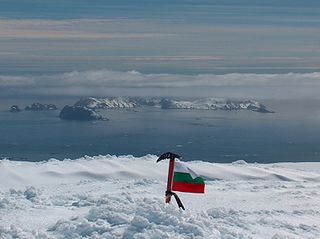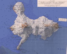
Clarence Island is the easternmost island in the South Shetland Islands, off the coast of Antarctica. It is claimed by Argentina as part of Argentine Antarctica, by Britain as part of the British Antarctic Territory, and by Chile as part of the Chilean Antarctic Territory. The name dates back to at least 1820 and is now established in international usage, except for Russia, where it has been known as Shishkova Island since its discovery by the First Russian Antarctic Expedition in 1821.

Perunika Glacier is an 8 km long and 3 km wide (average) roughly crescent-shaped glacier in eastern Livingston Island in the South Shetland Islands, Antarctica situated east of Pimpirev Glacier, south of Saedinenie Snowfield, southwest of Kaliakra Glacier, west of Huron Glacier, and north of Balkan Snowfield and the head of Huntress Glacier.

Sea Lion Glacier is the site of an isolated 350 metres (1,150 ft) long glacier on Hurd Peninsula, eastern Livingston Island in the South Shetland Islands, Antarctica. It is located southwest of Hesperides Hill and northwest of Atlantic Club Ridge, separated from the latter by Sea Lion Tarn, and terminating on the South Bay coast.

Varna Peninsula is a roughly rectangular predominantly ice-covered peninsula forming the northeast extremity of Livingston Island in the South Shetland Islands, Antarctica. It is bounded by Hero Bay to the northwest, by Moon Bay to the southeast, and by McFarlane Strait to the northeast.

Vergilov Rocks are a group of rocks off Bulgarian Beach on Hurd Peninsula in eastern Livingston Island in the South Shetland Islands, Antarctica, consisting of one main rock and two adjacent smaller ones submerging at high water.

Start Point is a point marking the northwest end of Byers Peninsula, Livingston Island in the South Shetland Islands, Antarctica and forming the southwest side of the entrance to Svishtov Cove and the northeast side of the entrance to the New Plymouth bay. Discovered by Edward Bransfield in January 1820, and so named by him because of its resemblance to a point on the south coast of England by the same name and because it was the place where his operations began.

The Antarctic Place-names Commission was established by the Bulgarian Antarctic Institute in 1994, and since 2001 has been a body affiliated with the Ministry of Foreign Affairs of Bulgaria.

Desolation Island is one of the minor islands in the South Shetlands archipelago, Antarctica situated at the entrance to Hero Bay, Livingston Island. The island is V-shaped with its northern coast indented by Kozma Cove. Surface area is 3.12 square kilometres (1.20 sq mi).

Valchedram Island is an ice-free island off the north coast of Livingston Island in the South Shetland Islands, Antarctica extending 280 m (310 yd) in southeast-northwest direction. The feature is named after the town of Valchedram in northwestern Bulgaria.

Williams Point is the point forming both the north extremity of Varna Peninsula and the northeast tip of Livingston Island in the South Shetland Islands, Antarctica. Separated from Zed Islands to the north by Iglika Passage.

Vardim Rocks are a group of rocks situated on the south side of Hell Gates, facing Devils Point in the southwest extremity of Byers Peninsula on Livingston Island in the South Shetland Islands, Antarctica. Extending 1.3 km (0.81 mi) in east-west direction. The two principal islets in the group, Demon and Sprite, are extending 420 by 400 m and 270 by 150 m respectively, with surface area of the former 9 hectares. The area was visited by early 19th century sealers.

Essex Point is a point at the northwest end of Byers Peninsula, Livingston Island in the South Shetland Islands, Antarctica. It forms the west side of the entrance to Barclay Bay and the northeast side of the entrance to Svishtov Cove, and is surmounted by Drong Hill.

Window Island is a small ice-free island off the north coast of Ray Promontory in the northwest of Byers Peninsula, Livingston Island in the South Shetland Islands, Antarctica. The island has a surface area of 23 hectares and rises to 72 m (236 ft). It was known to the early 19th century sealers operating on Byers Peninsula.

Sally Rocks is a small group of rocks trending southwestwards in South Bay just off the west coast of Hurd Peninsula, Livingston Island in the South Shetland Islands, Antarctica.

Eddystone Rocks is a group of two rocks lying to the northwest of Rugged Island off western Livingston Island in the South Shetland Islands, Antarctica.

Las Palmas Glacier is a glacier flowing west-northwest from Hurd Dome and terminating at Las Palmas Cove, South Bay, Livingston Island, Antarctica. The name was given by the Spanish Antarctic Expedition, about 1991, after the ship Las Palmas of the Spanish Antarctic campaigns since 1988.

Smolensk Strait is the strait in the South Shetland Islands, Antarctica separating Deception Island from Rozhen Peninsula on Livingston Island, 18.4 km wide between Macaroni Point to the southwest and Barnard Point to the northeast.

Toledo Island is the southern of two rocky islands in Smyadovo Cove on the west coast of Rugged Island in the South Shetland Islands. The feature is 320 m (1,050 ft) long in east–west direction and 110 m (360 ft) wide. It is separated from Rugged Island to the southeast and Prosechen Island to the north by 40 and 60 m wide passages respectively. The area was visited by early 19th century sealers.
Pindarev Island is an island in Antarctica. It is 250 metres (820 ft) long in southeast-northwest direction and 115 metres (377 ft) wide flat rocky island in Nishava Cove, separated from the north coast of Rugged Island in the South Shetland Islands by a 35 metres (115 ft) wide passage. Its surface area is 1.9 hectares. The area was visited by early 19th century sealers.

Kianida Reef is the 350 m long in east-west direction and 140 m wide, narrowing to the east rocky reef lying in Osogovo Bay, off the southeast extremity of Rugged Island in the South Shetland Islands. Its surface area is 4 ha. The area was visited by early 19th century sealers.


