
Cape Wadworth is the northern extremity of Coulman Island, in the Ross Sea just off Victoria Land. Discovered 17 January 1841 by Sir James Clark Ross who named it to compliment his wife's uncle, Robert John Coulman of Wadworth Hall, Doncaster.
Cape Wadworth is the northern extremity of Coulman Island, in the Ross Sea just off Victoria Land. Discovered 17 January 1841 by Sir James Clark Ross who named it to compliment his wife's uncle, Robert John Coulman of Wadworth Hall, Doncaster.
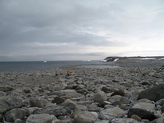
A message post was placed at the cape by Robert Falcon Scott on 15 January 1902. It consisted of a metal cylinder nailed to a red pole erected 8 m above sea level. The rocks behind the post were painted red and white to make it more conspicuous. The site has been designated a Historic Site or Monument (HSM 70), following a proposal by New Zealand, Norway and the United Kingdom to the Antarctic Treaty Consultative Meeting. [1]
A 415 ha site of sea ice about 5 km south-west of the cape has been designated an Important Bird Area (IBA) by BirdLife International because it supports a colony of about 25,000 emperor penguins (estimated from 2009 satellite imagery). [2]

Stonington Island is a rocky island lying 1.8 km (1.1 mi) northeast of Neny Island in the eastern part of Marguerite Bay off the west coast of Graham Land, Antarctica. It is 0.75 km (0.47 mi) long from north-west to south-east and 0.37 km (0.23 mi) wide, yielding an area of 20 ha. It was formerly connected by a drifted snow slope to Northeast Glacier on the mainland. Highest elevation is Anemometer Hill which rises to 25 m (82 ft).

Cape Denison is a rocky point at the head of Commonwealth Bay in George V Land, Antarctica. It was discovered in 1912 by the Australasian Antarctic Expedition (1911–14) under Douglas Mawson, who named it for Sir Hugh Denison of Sydney, a patron of the expedition. The cape was the site of the expedition's main base. Called by Mawson "the windiest place on Earth", the site experiences fierce katabatic winds.

Snow Hill Island is an almost completely snowcapped island, 33 km (21 mi) long and 12 km (7.5 mi) wide, lying off the east coast of the Antarctic Peninsula. It is separated from James Ross Island to the north-east by Admiralty Sound and from Seymour Island to the north by Picnic Passage. It is one of several islands around the peninsula known as Graham Land, which is closer to Argentina and South America than any other part of the Antarctic continent.
Cape Adare is a prominent cape of black basalt forming the northern tip of the Adare Peninsula and the north-easternmost extremity of Victoria Land, East Antarctica.
Inexpressible Island is a small, rocky island in Terra Nova Bay, Victoria Land, Antarctica.
Hut Point Peninsula is a long, narrow peninsula from 3 to 5 km wide and 24 km (15 mi) long, projecting south-west from the slopes of Mount Erebus on Ross Island, Antarctica. McMurdo Station (US) and Scott Base (NZ) are Antarctic research stations located on the Hut Point Peninsula.
Cape Evans is a rocky cape on the west side of Ross Island, Antarctica, forming the north side of the entrance to Erebus Bay.
Cape Crozier is the most easterly point of Ross Island in Antarctica. It was discovered in 1841 during James Clark Ross's expedition of 1839 to 1843 with HMS Erebus and HMS Terror, and was named after Francis Crozier, captain of HMS Terror. The extinct volcano Mount Terror, also named during the Ross expedition, rises sharply from the Cape to a height of 3,230 m (10,600 ft), and the edge of the Ross Ice Shelf stretches away to its east.

Yankee Harbour is a small inner harbour entered from Shopski Cove between Glacier Bluff and Spit Point, indenting the south-west side of Greenwich Island in the South Shetland Islands, Antarctica. It is 2.35 km (1.46 mi) long in west-south-west to east-north-east direction, and 1.6 km (0.99 mi) wide, and is bounded by Provadiya Hook to the south-west, Parvomay Neck to the north and east, and Kladara Beach to the south.
Foyn Island, also known as Svend Foyn Island, is the second largest island in the Possession Islands, East Antarctica, lying 6 kilometres (4 mi) south-west of Possession Island. An Adélie penguin rookery covers much of the island, which is often included in the itinerary of Antarctic cruises.
Cape Bruce forms the northern tip of a small island lying at the eastern side of Oom Bay, separated from the mainland rocks just west of Taylor Glacier in Mac. Robertson Land, Antarctica.
The Tryne Islands are a group of numerous small Antarctic islands and rocks, about 7 km (4 mi) in extent, forming the western limit of Tryne Bay and Tryne Sound at the north-eastern end of the Vestfold Hills. The islands were mapped by Norwegian cartographers from aerial photographs taken by the Lars Christensen Expedition (1936–37) and named Trynøyane.

The Cape-Pigeon Rocks are twin rocky promontories on the western side of Watt Bay, 6 kilometres (3 nmi) south of Garnet Point. They were discovered by the Australasian Antarctic Expedition (1911–14) under Douglas Mawson, who gave the name because of the large rookery of Cape petrels here. The Advisory Committee on Antarctic Names added a hyphen between the first and second words in the specific part of the name to reduce ambiguity and emphasize the generic term "Rocks".
Cape Polar Sea is a rock cape that forms the west extremity of Coulman Island in northwest Ross Sea. Named in 1998 by Advisory Committee on Antarctic Names (US-ACAN) after USCGC Polar Sea, an icebreaker in support of United States Antarctic Program (USAP) activities in the Ross, Amundsen and Bellingshausen Seas, and other Antarctic coastal areas during 11 seasons, 1980–1997. The cape lies in proximity to Cape Polar Star and Glacier Strait, two features named earlier for American icebreakers.

The Géologie Archipelago, also known as the Pointe Géologie Archipelago, Geology Archipelago or Cape Geology Archipelago, is a small archipelago of rocky islands and rocks close to the north of Cape Géodésie and Astrolabe Glacier Tongue, extending from Helene Island on the west to the Dumoulin Islands on the east, in Adélie Land, Antarctica.

Haswell Island is the largest of the Haswell Islands, lying off the coast of Antarctica, about 3 kilometres (1.5 nmi) north of Mabus Point in Queen Mary Land. It was discovered by the Western Base Party of the Australasian Antarctic Expedition, 1911–14, under Mawson, and named by him for Professor William A. Haswell, a zoologist at Sydney University and a member of the expedition's Advisory Committee.

Cape Main is a small cape situated 5 nautical miles (9 km) north of Cape Anne, along the east side of Coulman Island, Victoria Land, Antarctica. It was named by the New Zealand Antarctic Place-Names Committee in 1966 for Brian Main, a scientific technician at Hallett Station, 1962–63.
Seabee Hook is a low, recurved spit composed of coarse volcanic ash which projects about 900 m (984 yd) west from the high rocky ridge forming Cape Hallett, along the coast of Victoria Land. In January 1956, members of the US Navy's Operation Deep Freeze aboard the icebreaker USS Edisto investigated and surveyed this area for possible use as a base site for International Geophysical Year operations. Seabee is a phonetic spelling of CB and refers to individual or collective members of naval construction engineer units.
Lewis Bay is a bay indenting the north coast of Ross Island, Antarctica, between Mount Bird and Cape Tennyson.
Ponganis Icefall is an icefall, 1,000 metres (3,300 ft) high and 1.25 nautical miles (2.32 km) wide on the east side of Coulman Island in the Ross Sea. The icefall descends from the Hawkes Heights caldera to the sea at Cape Main. It was named by the Advisory Committee on Antarctic Names in 2005 after Paul J. Ponganis, Center for Marine Biotechnology, Scripps Institution of Oceanography, who studied the behavior and census of Emperor penguins at Cape Crozier, Cape Washington, Beaufort Island, Franklin Island and Coulman Island in 13 field seasons, from 1987 to 2004, and for Katherine V. Ponganis, a member of the study team in five field seasons.
Coordinates: 73°19′S169°47′E / 73.317°S 169.783°E
| | This Borchgrevink Coast location article is a stub. You can help Wikipedia by expanding it. |