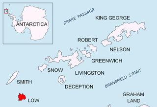
Low Island or Isla Baja, historical names Jameson Island or Jamesons Island, is an island 9 miles (14 km) long and 5 miles (8 km) wide, 14 miles (23 km) southeast of Smith Island in the South Shetland Islands. The island is located at 63°17′S62°09′W and is separated from Smith Island by Osmar Strait. Low Island was so named because of its low elevation. Low Island was known to sealers in 1820, and the name Low Island has been established in international usage for 100 years.

Cape Lookout, also known as Cabo Fossatti or Cabo Vigia, is a steep cape, 240 m high, marking the southern extremity of Elephant Island in the South Shetland Islands of Antarctica. The name Cape Lookout appears on a map of 1822 by Captain George Powell, a British sealer, and is now established in international usage.

Cape Hooker is the south-eastern point of Low Island, in the South Shetland Islands of Antarctica. The feature was roughly charted by nineteenth century sealers; it was further charted by Commander Henry Foster in 1829 but shown as the north-eastern point of the island. Following air photography by the Falkland Islands and Dependencies Aerial Survey Expedition in 1956, the charted shape of the island was drastically altered and the name Cape Hooker was applied to its south-eastern point as originally described.

Cape Shirreff is a prominent cape at the north end of the rocky peninsula which separates Hero Bay and Barclay Bay on the north coast of Livingston Island, in the South Shetland Islands of Antarctica. The cape was named by Edward Bransfield in 1820 after Captain William H. Shirreff, the British commanding officer in the Pacific at that time.
Avian Island is an island, 1.2 km (0.7 mi) long and 40 metres (130 ft) high, lying close off the south tip of Adelaide Island, Antarctica. It was discovered by the French Antarctic Expedition, 1908–10, under Jean-Baptiste Charcot, and visited in 1948 by the Falkland Islands Dependencies Survey, who so named it because of the large number and variety of birds (avians) found there.

Barnard Point is a headland which marks the south-east side of the entrance to False Bay on the south side of Livingston Island in the South Shetland Islands, Antarctica. It is situated on Rozhen Peninsula, 1.5 km (1 mi) north-north-west of Botev Point and 6.6 km (4 mi) south-east of Miers Bluff.

Cape Bowles is a cape forming the southern extremity of Clarence Island in the South Shetland Islands of Antarctica. It was named in 1820 by Edward Bransfield, Master, Royal Navy, while exploring the islands in the brig Williams.

Caughley Beach is the northernmost beach on the ice-free coast south-west of Cape Bird, Ross Island, Antarctica. It was mapped by the New Zealand Geological Survey Antarctic Expedition, 1958–59, and named for Graeme Caughley, biologist with the party that visited Cape Bird. New College Valley, Antarctic Specially Protected Area (ASPA) No.116, lies above the beach.

Cape Whitson, is a headland on the south coast of Laurie Island, the easternmost and second largest of the South Orkney Islands of Antarctica. It lies about 9 km south-east of Argentina’s Orcadas Base.
D'Urville Monument is a conspicuous conical summit, 575 m (1,886 ft) high, at the south-west end of Joinville Island, off the north-east end of the Antarctic Peninsula. It was discovered by a British expedition under James Clark Ross between 1839 and 1843. It was named by him for Captain Jules Dumont d'Urville.
Jameson Point is a small headland on the north side of the entrance to Malina Cove, situated 6.3 km (3.9 mi) north of Cape Garry on the west side of Low Island, in the South Shetland Islands of Antarctica. It was roughly charted by the French Antarctic Expedition, 1908–10. The point was photographed from the air by the Falkland Islands and Dependencies Aerial Survey Expedition, 1955–57, and more accurately delineated from these photos by the Falkland Islands Dependencies Survey in 1959. The name "Jameson Island" was applied to Low Island by James Weddell in 1820–23, and Jameson Point has been approved for this point to preserve Weddell's name on Low Island.
The Tupinier Islands are a group of pyramid-shaped islands lying off the north coast of Trinity Peninsula, about 6 km (3.7 mi) west of Cape Ducorps. They were discovered by the French expedition under Captain Jules Dumont d'Urville, 1837–40, and named after Baron Tupinier (1779–1850), an official of the French Naval Ministry who was instrumental in obtaining government support for the expedition. The islands were recharted by the Falkland Islands Dependencies Survey (FIDS) in 1946.
Potter Peninsula is a low ice-free peninsula between Potter Cove and Stranger Point in south-west King George Island, in the South Shetland Islands of Antarctica. It is protected as ASPA 132, largely because of the richness and diversity of its flora and fauna.
Mount Elder is a 940-metre (3,080 ft) mountain lying between Endurance Glacier and Mount Pendragon on Elephant Island, in the South Shetland Islands of Antarctica. It was named by the UK Antarctic Place-Names Committee for Captain John P. Elder, Royal Engineers, surveyor of the U.K. Joint Services Expedition to Elephant Island in 1970–71.
Cape Garry is a cape forming the south-western extremity of Low Island in the South Shetland Islands of Antarctica. It was charted and named by a British expedition under Henry Foster, 1828–31, and was more accurately mapped by the Falkland Islands Dependencies Survey in 1959 from aerial photographs taken by the Falkland Islands and Dependencies Aerial Survey Expedition, 1955–57.
Cape Hansen is a cape which separates Marshall Bay and Iceberg Bay on the south coast of Coronation Island, in the South Orkney Islands, Antarctica. The name appears on a chart based upon a running survey of the islands in 1912–13 by Petter Sørlle, a Norwegian whaling captain.

Harmony Point is a point which lies close west of Harmony Cove and forms both the south side of the entrance to Malak Sechko Cove and the western extremity of Guangzhou Peninsula and Nelson Island, in the South Shetland Islands of Antarctica. It was charted in 1935 by Discovery Investigations personnel on the Discovery II, and named from association with Harmony Cove.
Lions Rump is a conspicuous headland 2 km (1.2 mi) north-northeast of Low Head, forming the west side of the entrance to King George Bay, on King George Island, in the South Shetland Islands of Antarctica. It was charted and given its descriptive name in 1937 by Discovery Investigations personnel on the Discovery II. Chopin Ridge runs between Lions Rump and Low Head. The rock feature known as "Martello Tower" lies 4 km (2.5 mi) to the north-northwest.
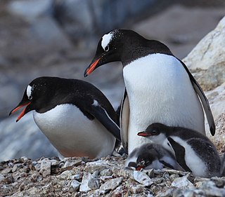
Cape Melville, is a low-lying, ice-free headland at the eastern end of King George Island in the South Shetland Islands of Antarctica. Some 388 ha of the site has been identified as an Important Bird Area (IBA) by BirdLife International because it supports a large breeding colony of about 16000 pairs of chinstrap penguins.

Baily Head is a prominent headland, 160 m high, forming the easternmost extremity of Deception Island, in the South Shetland Islands of Antarctica.
