
Signy Island is a small subantarctic island in the South Orkney Islands of Antarctica. It was named by the Norwegian whaler Petter Sørlle (1884–1933) after his wife, Signy Therese.

Admiralty Bay is an irregular bay, 8 km (5 mi) wide at its entrance between Demay Point and Martins Head, indenting the southern coast of King George Island for 16 km (10 mi), in the South Shetland Islands of Antarctica. The name appears on a map of 1822 by Captain George Powell, a British sailor, and is now established in international usage. The Henryk Arctowski Polish Antarctic Station is situated on the bay, as is the Comandante Ferraz Brazilian Antarctic Base. It has been designated an Antarctic Specially Managed Area.

Peterson Island is a rocky island, 3.5 km (2.2 mi) long, with two inlets indenting the north side, lying west of, and separated by a narrow channel 200-400 m wide from, the Browning Peninsula, in the southern part of the Windmill Islands on the Budd Coast of Wilkes Land, Antarctica.

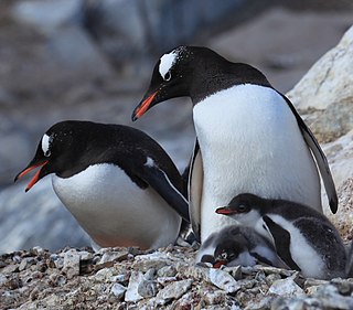
The Bay of Isles is a bay 9 miles (14 km) wide and receding 3 miles (5 km), lying between Cape Buller and Cape Wilson along the north coast of South Georgia. It was discovered in 1775 by a British expedition under James Cook and so named by him because numerous islands lie in the bay. Of South Georgia's 31 breeding bird species, 17 are found here.

Yankee Harbour is a small inner harbour entered from Shopski Cove between Glacier Bluff and Spit Point, indenting the south-west side of Greenwich Island in the South Shetland Islands, Antarctica. It is 2.35 km (1.46 mi) long in west-south-west to east-north-east direction, and 1.6 km (0.99 mi) wide, and is bounded by Provadiya Hook to the south-west, Parvomay Neck to the north and east, and Kladara Beach to the south.

Ezcurra Inlet is an inlet forming the western arm of Admiralty Bay, King George Island, in the South Shetland Islands. It was charted by the French Antarctic Expedition, 1908–10, under Jean-Baptiste Charcot, and named "Fiord Ezcurra" after Pedro de Ezcurra, an Argentine politician and Minister of Agriculture in 1908, who assisted the French expedition.
Avian Island is an island, 1.2 km (0.7 mi) long and 40 metres (130 ft) high, lying close off the south tip of Adelaide Island, Antarctica. It was discovered by the French Antarctic Expedition, 1908–10, under Jean-Baptiste Charcot, and visited in 1948 by the Falkland Islands Dependencies Survey, who so named it because of the large number and variety of birds (avians) found there.

Clark Peninsula is a rocky peninsula, about 3 km (2 mi) long and wide, lying 5 km (3 mi) north-east of Australia's Casey Station at the north side of Newcomb Bay on the Budd Coast of Wilkes Land in Antarctica.

Ardley Island is an island 1.9 kilometres (1 nmi) long, lying in Maxwell Bay close off the south-west end of King George Island, in the South Shetland Islands of Antarctica. It was charted as a peninsula in 1935 by Discovery Investigations personnel of the Discovery II and named for Lieutenant R.A.B. Ardley, Royal Naval Reserve, an officer on the ship in 1929–31 and 1931–33. Aerial photography has since shown that the feature is an island with Braillard Point being the headland forming the northeast end of Ardley Island. It has been designated an Antarctic Specially Protected Area because of the importance of its seabird colonies.
Wawel Hill is a hill rising to 290 m north of Point Hennequin, on the east side of Admiralty Bay, King George Island. Named "Gora Wawel" in 1980 by the Polish Antarctic Expedition after a hill by this name in Kraków, historic site of the castle of the Polish kings.
Denais Stack is a conspicuous rock stack lying 1.5 nautical miles (3 km) north of Point Thomas on the west side of Admiralty Bay, King George Island, in the South Shetland Islands. The name "Anse Denais," for one of the seamen on the Pourquoi-Pas?, was given by the French Antarctic Expedition, 1908–10, under Jean-Baptiste Charcot to a cove on the north side of Ezcurra Inlet. Recent air photos show no cove in this position and the name Denais has been transferred to the feature now described in order to preserve Charcot's naming in the area.
Potter Peninsula is a low ice-free peninsula between Potter Cove and Stranger Point in south-west King George Island, in the South Shetland Islands of Antarctica. It is protected as ASPA 132, largely because of the richness and diversity of its flora and fauna.

The Géologie Archipelago, also known as the Pointe Géologie Archipelago, Geology Archipelago or Cape Geology Archipelago, is a small archipelago of rocky islands and rocks close to the north of Cape Géodésie and Astrolabe Glacier Tongue, extending from Helene Island on the west to the Dumoulin Islands on the east, in Adélie Land, Antarctica.

Harmony Point is a point which lies close west of Harmony Cove and forms both the south side of the entrance to Malak Sechko Cove and the western extremity of Nelson Island, in the South Shetland Islands of Antarctica. It was charted in 1935 by Discovery Investigations personnel on the Discovery II, and named from association with Harmony Cove.
Lions Rump is a conspicuous headland 2 km (1.2 mi) north-northeast of Low Head, forming the west side of the entrance to King George Bay, on King George Island, in the South Shetland Islands of Antarctica. It was charted and given its descriptive name in 1937 by Discovery Investigations personnel on the Discovery II. Chopin Ridge runs between Lions Rump and Low Head. The rock feature known as "Martello Tower" lies 4 km (2.5 mi) to the north-northwest.
Haswell Island is the largest of the Haswell Islands, lying off the coast of Antarctica, about 3 kilometres (1.5 nmi) north of Mabus Point in Queen Mary Land. It was discovered by the Western Base Party of the Australasian Antarctic Expedition, 1911–14, under Mawson, and named by him for Professor William A. Haswell, a zoologist at Sydney University and a member of the expedition's Advisory Committee.
The Mackellar Islands, also MacKellar Islets, are a group of about 30 small islands and rocks lying 3 kilometres (1.5 nmi) north of Cape Denison in the center of Commonwealth Bay, George V Land, Antarctica. They were discovered by the Australasian Antarctic Expedition (1911–14) under Douglas Mawson, who named them for C.D. Mackellar of London, a patron of the expedition. The largest is Greater Mackellar Island.
Lagotellerie Island is an island 1.9 kilometres (1 nmi) long, lying 3.7 kilometres (2 nmi) west of Horseshoe Island in Marguerite Bay, off the west coast of Graham Land, Antarctica. It was discovered and named by the French Antarctic Expedition, 1908–10, under Jean-Baptiste Charcot.
Narębski Point is a headland on the south-east coast of the Barton Peninsula, at the south-western end of King George Island, in the South Shetland Islands of Antarctica with an average elevation of 0 feet above sea level. Korea’s King Sejong Station lies 2 km to the north-east.

The Ryder Bay Islands Important Bird Area is a 520 ha designated site on the south-east coast of Adelaide Island, Antarctica. It has been identified as an Important Bird Area (IBA) by BirdLife International because it supports significant numbers of breeding seabirds, notably south polar skuas. The site encompasses the Léonie Islands lying at the mouth of Ryder Bay, as well as Rothera Point, the eastern headland of the bay.
