Ross Island is an island in Antarctica lying on the east side of McMurdo Sound and extending 43 nautical miles from Cape Bird on the north to Cape Armitage on the south, and a like distance from Cape Royds on the west to Cape Crozier on the east. The island is entirely volcanic. Mount Erebus, 3,795 metres (12,451 ft), near the center, is an active volcano. Mount Terror, 3,230 metres (10,600 ft), about 20 nautical miles eastward, is an extinct volcano. Mount Bird rises to 1,765 metres (5,791 ft) just south of Cape Bird. Ross Island lies within the boundary of Ross Dependency, an area of Antarctica claimed by New Zealand.

The McMurdo Sound is a sound in Antarctica, known as the southernmost passable body of water in the world, located approximately 1,300 kilometres (810 mi) from the South Pole.

The Scullin Monolith is a crescent-shaped rock fronting the sea 6 km (3.7 mi) west of the similar Murray Monolith, and 8 km (5.0 mi) from Torlyn Mountain, in Mac. Robertson Land, Antarctica. It is a steep massif of metasedimentary gneiss and granitic origin, with the adjacent coastline consisting of 40 m high ice cliffs. The monolith rises steeply to extend from 435 m high Mikkelsen Peak westward in a crescent that forms Douglas Bay.

Cape Hallett is a snow-free area on the northern tip of the Hallett Peninsula on the Ross Sea coast of Victoria Land, East Antarctica. Cape Adare lies 100 km (62 mi) to the north.

Litchfield Island is a rocky island 0.9 kilometres (0.5 nmi) long and rising to 50 m (164 ft), lying in Arthur Harbour, 0.9 kilometres (0.5 nmi) south of Norsel Point, off the south-west coast of Anvers Island in the Palmer Archipelago of Antarctica.
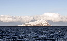
White Island is an island in the Ross Archipelago of Antarctica. It is 15 nautical miles long, protruding through the Ross Ice Shelf immediately east of Black Island. It was discovered by the British National Antarctic Expedition (1901–04) and so named by them because of the mantle of snow which covers it.
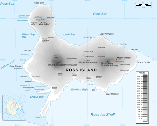
Cape Crozier is the most easterly point of Ross Island in Antarctica. It was discovered in 1841 during James Clark Ross's expedition of 1839 to 1843 with HMS Erebus and HMS Terror, and was named after Commander Francis Crozier, captain of HMS Terror, one of the two ships of Ross' expedition.

Byers Peninsula is a mainly ice-free peninsula forming the west end of Livingston Island in the South Shetland Islands of Antarctica. It occupies 60 km2 (23 sq mi), borders Ivanov Beach to the northeast and is separated from Rotch Dome on the east by the ridge of Urvich Wall. The peninsula features more than 60 meltwater streams and as many lakes, notably Midge Lake, Limnopolar Lake and Basalt Lake. Byers Peninsula has a regime of special environmental protection under the Antarctic Treaty System and requires a permit to enter.

Coppermine Peninsula is the rugged, rocky promontory forming the northwest extremity of Alfatar Peninsula and Robert Island in the South Shetland Islands, Antarctica. It lies between the English Strait to the west and Carlota Cove to the east. It is 1.7 km long, 500 m wide and rising to 105 m.
Caughley Beach is the northernmost beach on the ice-free coast south-west of Cape Bird, Ross Island, Antarctica. It was mapped by the New Zealand Geological Survey Antarctic Expedition, 1958–59, and named for Graeme Caughley, biologist with the party that visited Cape Bird. New College Valley, Antarctic Specially Protected Area (ASPA) No.116, lies above the beach.

Edmonson Point is a rounded, largely ice-free point lying below Mount Melbourne along the west side of Wood Bay, Victoria Land, Antarctica. It was mapped by the United States Geological Survey from surveys and from US Navy air photographs, 1955–63, and was named by the Advisory Committee on Antarctic Names for Larry Edmonson, a satellite geodesy scientist at McMurdo Station, winter party 1966.
Haswell Island is the largest of the Haswell Islands, lying off the coast of Antarctica, about 3 kilometres (1.5 nmi) north of Mabus Point in Queen Mary Land. It was discovered by the Western Base Party of the Australasian Antarctic Expedition, 1911–14, under Mawson, and named by him for Professor William A. Haswell, a zoologist at Sydney University and a member of the expedition's Advisory Committee.
Lagotellerie Island is an island 1.9 kilometres (1 nmi) long, lying 3.7 kilometres (2 nmi) west of Horseshoe Island in Marguerite Bay, off the west coast of Graham Land, Antarctica. It was discovered and named by the French Antarctic Expedition, 1908–10, under Jean-Baptiste Charcot.
Lamarck Island is a rocky island 250 m (820 ft) long, lying 300 m (980 ft) east of Petrel Island and 300 m (980 ft) north-east of Rostand Island in the Géologie Archipelago, off the Adélie Coast of Antarctica. It was charted in 1951 by the French Antarctic Expedition and named by them after Jean-Baptiste Lamarck, the French naturalist.

The Cierva Point and offshore islands Important Bird Area is a 6540 ha tract of land and sea on the Danco Coast of the Antarctic Peninsula.

Amanda Bay, also sometimes known as Hovde Cove, lies in southern Prydz Bay on the Ingrid Christensen Coast of Princess Elizabeth Land, East Antarctica. It is best known for its breeding colony of several thousand pairs of emperor penguins on sea ice at the south-west corner of the bay.

The Ablation Point – Ganymede Heights Antarctic Specially Protected Area is a 180 km2 mountainous tract of land on the eastern side of Alexander Island in the Bellinghausen Sea, west of Palmer Land on the Antarctic Peninsula. It has been designated Antarctic Specially Protected Area (ASPA) No.147 for its geological, geomorphological, glaciological, limnological, and ecological values, and to protect its terrestrial and freshwater ecosystems from uncontrolled human visitation and activity.

The North-west White Island Antarctic Specially Protected Area comprises a 142 km2 area of coastal shelf ice on the north-west side of White Island in the Ross Archipelago of Antarctica.The site has been designated an Antarctic Specially Protected Area because it supports an unusual small breeding population of Weddell seals, which is not only the most southerly known, but which has also been physically isolated from other populations by the advance of the McMurdo and Ross ice shelves. The first seals in the area were recorded in 1958, since when the population has grown to 25–30. The seals use the open waters of McMurdo Sound but do not have the breathing capacity to reach the open ocean by swimming beneath the intervening 20 km of permanent shelf ice.
Mount Rittmann is a volcano in Antarctica. Discovered in 1988–1989 by an Italian expedition, it was named after the volcanologist Alfred Rittmann (1893–1980). It features a 2 kilometres (1.2 mi) or 8 by 5 kilometres wide caldera which crops out from underneath the Aviator Glacier. The volcano was active during the Pliocene and into the Holocene, including large explosive eruptions; a major eruption occurred in 1254 CE and deposited tephra over much of Antarctica. Currently, the volcano is classified as dormant.
The Ryder Bay Islands Important Bird Area is a 520 ha designated site on the south-east coast of Adelaide Island, Antarctica. It has been identified as an Important Bird Area (IBA) by BirdLife International because it supports significant numbers of breeding seabirds, notably south polar skuas. The site encompasses the Léonie Islands lying at the mouth of Ryder Bay, as well as Rothera Point, the eastern headland of the bay.