
Trinity Island or Île de la Trinité or Isla Trinidad is an island 24 km (15 mi) long and 10 km (6 mi) wide in the northern part of the Palmer Archipelago, Antarctica. It lies 37 km (23 mi) east of Hoseason Island,72.6 km (45 mi) south of Deception Island in the South Shetland Islands, and 10.3 km (6 mi) north-northwest of Cape Andreas on the Antarctic Peninsula. The island was named by Otto Nordenskiöld, leader of the 1901-1904 Swedish Antarctic Expedition (SAE) in commemoration of Edward Bransfield's "Trinity Land" of 1820.

Aspland Island is a small island 7.4 km (4 nmi) west of Gibbs Island in the South Shetland Islands of Antarctica. The name dates back to at least 1821.

Cape Bowles is a cape forming the southern extremity of Clarence Island in the South Shetland Islands of Antarctica. It was named in 1820 by Edward Bransfield, Master, Royal Navy, while exploring the islands in the brig Williams.

Buchanan Point is a headland 5 km (3.1 mi) north-west of Cape Dundas and 2 km (1.2 mi) south-east of Mackintosh Cove, at the north-eastern end of Laurie Island in the South Orkney Islands of Antarctica.
Chinstrap Cove is a cove 6 km (3.7 mi) north-east of Escarpada Point on the north-west coast of Clarence Island, South Shetland Islands, Antarctica entered northeast of Vaglen Point. The cove has been identified as an Important Bird Area (IBA) by BirdLife International because it supports a large breeding colony of about 20,000 pairs of chinstrap penguins, after which it was named by the UK Joint Services Expedition which visited the site in 1970–1971. The 74 ha IBA includes the ice-free area south of the cove, extending 2 km along the coast.
Walker Point is a point on the southwest side of the entrance to Gurkovska Cove which lies 6 km (3.7 mi) south-west of Cape Valentine, near the eastern end of Elephant Island in the South Shetland Islands of Antarctica. The name appears on Powell's map of 1822 based upon the joint cruise of Captain Nathaniel B. Palmer, in the sloop James Monroe with Captain George Powell, in the sloop Dove, in December 1821. It was probably named for Captain John Walker, whose assistance in the construction of the map was acknowledged by Powell.
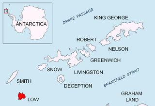
Cape Wallace is the cape marking the northern extremity of Limets Peninsula and the north-west end of Low Island in the South Shetland Islands of Antarctica. Though the origin of the name Cape Wallace is unknown, it has appeared on charts for over a hundred years and its usage has been established internationally.
Jameson Point is a small headland on the north side of the entrance to Malina Cove, situated 6.3 km (3.9 mi) north of Cape Garry on the west side of Low Island, in the South Shetland Islands of Antarctica. It was roughly charted by the French Antarctic Expedition, 1908–10. The point was photographed from the air by the Falkland Islands and Dependencies Aerial Survey Expedition, 1955–57, and more accurately delineated from these photos by the Falkland Islands Dependencies Survey in 1959. The name "Jameson Island" was applied to Low Island by James Weddell in 1820–23, and Jameson Point has been approved for this point to preserve Weddell's name on Low Island.

Pottinger Point is a low-lying, ice-free promontory 4 km (2.5 mi) east of Round Point, about 500 m long, on the north coast of King George Island in the South Shetland Islands of Antarctica. It was named by the United Kingdom Antarctic Place-Names Committee (UK-APC) in 1960 for Captain Pottinger, Master of the Tartar from London, who visited the South Shetland Islands in 1821–22.
Eadie Island is an island 2 km (1.2 mi) long which lies between Aspland Island and O'Brien Island, in the South Shetland Islands of Antarctica. The island was first charted with its neighbours in February 1820, as the three 'O'Brien Islands', during a survey of the South Shetlands carried out by Edward Bransfield and William Smith (mariner). A year later they were rediscovered by a Russian expedition under Fabian Gottlieb von Bellingshausen, who used the name "Ostrova Tri Brata" for the present Aspland, Eadie and O'Brien Islands. Eadie Island was then named for the dockyard manager of the Melbourne Harbour Trust of Williamstown, Australia, by Lieutenant L. C. Hill of the Royal Naval Reserve, captain of the Discovery II, which engaged in survey work in the area in 1936–37.

Escarpada Point, also known as Craggy Point, is the rocky, rugged south-west point of Clarence Island in the South Shetland Islands of Antarctica. The descriptive name was given in the course of Argentine government visits in 1953–1954.
False Round Point is a point 16 km (9.9 mi) west of North Foreland and 4 km (2.5 mi) south of Ridley Island, on the north coast of King George Island in the South Shetland Islands of Antarctica. The point has appeared on charts since about 1822. It was probably named for its similarity to Round Point, which lies 22 km (14 mi) to the west, by Discovery Investigations personnel on the Discovery II who charted the north coast of this island in 1937.

Ferguslie Peninsula is a peninsula 2.4 km (1.5 mi) long, lying between Browns Bay and Macdougal Bay on the north coast of Laurie Island, in the South Orkney Islands of Antarctica. The peninsula was charted in 1903 by the Scottish National Antarctic Expedition under William Speirs Bruce, who named it for Ferguslie, the residence of James Coats, chief patron of the expedition.

Moe Island is an island 2 km (1.2 mi) long in the South Orkney Islands off Antarctica, separated from the south-west end of Signy Island by Fyr Channel. It was charted by Captain Petter Sørlle in 1912–13, and named after M. Thoralf Moe of Sandefjord, Norway, a contemporary whaling captain who worked in this area. The northernmost point of the island is Spaull Point, named by United Kingdom Antarctic Place-Names Committee (UK-APC) after Vaughan W. Spaull, British Antarctic Survey (BAS) biologist on Signy Island, 1969.
Cape Garry is a cape forming the south-western extremity of Low Island in the South Shetland Islands of Antarctica. It was charted and named by a British expedition under Henry Foster, 1828–31, and was more accurately mapped by the Falkland Islands Dependencies Survey in 1959 from aerial photographs taken by the Falkland Islands and Dependencies Aerial Survey Expedition, 1955–57.
Cape Hansen is a cape which separates Marshall Bay and Iceberg Bay on the south coast of Coronation Island, in the South Orkney Islands, Antarctica. The name appears on a chart based upon a running survey of the islands in 1912–13 by Petter Sørlle, a Norwegian whaling captain.

Harmony Point is a point which lies close west of Harmony Cove and forms the western extremity of Nelson Island, in the South Shetland Islands of Antarctica. It was charted in 1935 by Discovery Investigations personnel on the Discovery II, and named from association with Harmony Cove.
Lions Rump is a conspicuous headland 2 km (1.2 mi) north-northeast of Low Head, forming the west side of the entrance to King George Bay, on King George Island, in the South Shetland Islands of Antarctica. It was charted and given its descriptive name in 1937 by Discovery Investigations personnel on the Discovery II. Chopin Ridge runs between Lions Rump and Low Head. The rock feature known as "Martello Tower" lies 4 km (2.5 mi) to the north-northwest.

Point Hennequin is a point forming the eastern side of the entrance to Martel Inlet and Mackellar Inlet, on the east side of Admiralty Bay, King George Island, in the South Shetland Islands. It was named by the French Antarctic Expedition under Jean-Baptiste Charcot, who surveyed Admiralty Bay in 1909.

The Madder Cliffs are reddish rock cliffs which form the north side of the entrance to Suspiros Bay, at the west end of Joinville Island, Antarctica. They rise steeply from the sea to about 305 metres (1,000 ft). The cliffs were surveyed by the Falkland Islands Dependencies Survey in 1953–54. The name, given in 1956 by the UK Antarctic Place-Names Committee, is descriptive of the red colour of the rocks, madder being a red vegetable pigment.
