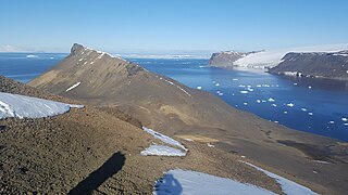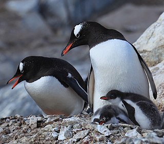
Penguin Island is one of the smaller of the South Shetland Islands of Antarctica.

Anvers Island or Antwerp Island or Antwerpen Island or Isla Amberes is a high, mountainous island 61 km long, the largest in the Palmer Archipelago of Antarctica. It was discovered by John Biscoe in 1832 and named in 1898 by the Belgian Antarctic Expedition under Adrien de Gerlache after the province of Antwerp in Belgium. It lies south-west of Brabant Island at the south-western end of the group. The south-western coastline of the island forms part of the Southwest Anvers Island and Palmer Basin Antarctic Specially Managed Area. Cormorant Island, an Important Bird Area, lies 1 km off the south coast.

Brabant Island is the second largest island of the Palmer Archipelago within the British Antarctic Territory, lying between Anvers Island and Liège Island. Brabant Island is 59 km (37 mi) long north-south, 30 km (19 mi) wide, and rises to 2,520 m (8,268 ft) in Mount Parry. The interior of the island is occupied by two mountain ranges, Solvay Mountains in its southern part and Stribog Mountains in its central and northern parts.

Cuverville Island or Île de Cavelier de Cuverville is a dark, rocky island lying in Errera Channel between Arctowski Peninsula and the northern part of Rongé Island, off the west coast of Graham Land in Antarctica. Cuverville Island was discovered by the Belgian Antarctic Expedition (1897–1899) under Adrien de Gerlache, who named it for Jules de Cuverville (1834–1912), a vice admiral of the French Navy.
Dream Island is an island lying 0.7 km (0.43 mi) south-east of Cape Monaco, off the south-west coast of Anvers Island in Wylie Bay, in the Palmer Archipelago of Antarctica. It was surveyed by the British Naval Hydrographic Survey Unit in 1956-1957 and named by the UK Antarctic Place-Names Committee for its natural features including a cave and, in summer, a small waterfall, with mossy patches and grass. It lies about 10 km north-west of the United States' Palmer Station.
Cormorant Island is a 10 ha island lying in Bismarck Strait 1 km south of Anvers Island, 4 km (2.5 mi) east-south-east of Bonaparte Point, in the Palmer Archipelago of Antarctica. It lies some 5 km to the south-east of the United States' Palmer Station in Arthur Harbour on Anvers Island. It was shown on an Argentine government chart of 1954, but not named. It was named by the United Kingdom Antarctic Place-names Committee (UK-APC) in 1958 because of the large number of cormorants (shags) seen there.

Gerlache Strait or de Gerlache Strait or Détroit de la Belgica is a channel/strait separating the Palmer Archipelago from the Antarctic Peninsula. The Belgian Antarctic Expedition, under Lt. Adrien de Gerlache, explored the strait in January and February 1898, naming it for the expedition ship Belgica. The name was later changed to honor the commander himself.
Arthur Harbour is a small harbour entered between Bonaparte Point and Amsler Island on the south-west coast of Anvers Island in the Palmer Archipelago of Antarctica.

Litchfield Island is a rocky island 0.9 kilometres (0.5 nmi) long and rising to 50 m (164 ft), lying in Arthur Harbour, 0.9 kilometres (0.5 nmi) south of Norsel Point, off the south-west coast of Anvers Island in the Palmer Archipelago of Antarctica.

Paulet Island is a circular island about 1.5 km (0.93 mi) in diameter, lying 4.5 km (2.8 mi) south-east of Dundee Island, off the north-eastern end of the Antarctic Peninsula. Because of its large penguin colony, it is a popular destination for sightseeing tours.

Trinity Island or Île de la Trinité or Isla Trinidad is an island 24 km (15 mi) long and 10 km (6 mi) wide in the northern part of the Palmer Archipelago, Antarctica. It lies 37 km (23 mi) east of Hoseason Island, 72.6 km (45 mi) south of Deception Island in the South Shetland Islands, and 10.3 km (6 mi) north-northwest of Cape Andreas on the Antarctic Peninsula. The island was named by Otto Nordenskiöld, leader of the 1901-1904 Swedish Antarctic Expedition (SAE) in commemoration of Edward Bransfield's "Trinity Land" of 1820.

Shirley Island is a rocky island lying 200 m (220 yd) north-west of the western end of the Bailey Peninsula, in the Windmill Islands of the Budd Coast, Wilkes Land, Antarctica. It is mostly ice-free with undulating, rocky terrain. It was first mapped from aerial photos taken by the USN's Operation Highjump in February 1947. It was named by the US-ACAN for Q. Shirley, chief photographer's mate on Operation Highjump photographic flights in coastal areas between 14° and 164° E longitude. Kirkby Shoal is a small shoal area with depths of less than 18 meters (59 ft) extending about 140 meters (459 ft) westwards and south-south-west, about 3.4 km (2.1 mi) from the summit of Shirley Island. Launch Channel is the narrow body of water between Bailey Peninsula and the island; with the relatively shallow soundings in the channel restricting its use to smaller craft and suggesting the name.

Devil Island is a 128 ha, ice-free island about 2 km long, in the James Ross Island group near the north-eastern tip of the Antarctic Peninsula. It lies in a small cove 1 km north of Vega Island, east of the Trinity Peninsula. It is characterised by several low hills rising to a maximum height of about 150 m.

The Joubin Islands are a group of small islands lying 6 kilometres (3 nmi) south-west of Cape Monaco, Anvers Island, at the south-western end of the Palmer Archipelago of Antarctica. The islands were discovered by the French Antarctic Expedition, 1903–05, under Jean-Baptiste Charcot, and named by him for Louis Joubin, the French naturalist. They have been designated a Restricted Zone under ASMA 7 — Southwest Anvers Island and Palmer Basin — which includes the marine area extending 50 metres (55 yd) from the shorelines.

Potter Peninsula is a low ice-free peninsula between Potter Cove and Stranger Point in south-west King George Island, in the South Shetland Islands of Antarctica. It is protected as ASPA 132, largely because of the richness and diversity of its flora and fauna.

Ferguslie Peninsula is a peninsula 2.4 km (1.5 mi) long, lying between Browns Bay and Macdougal Bay on the north coast of Laurie Island, in the South Orkney Islands of Antarctica. The peninsula was charted in 1903 by the Scottish National Antarctic Expedition under William Speirs Bruce, who named it for Ferguslie, the residence of James Coats, chief patron of the expedition.

Gerlache Island is the largest of the Rosenthal Islands lying off Gerlache Point on the west coast of Anvers Island, in the Palmer Archipelago of Antarctica. It was first roughly charted and named "Pointe de Gerlache" by the French Antarctic Expedition, 1903–05, under Jean-Baptiste Charcot, for Lieutenant Adrien de Gerlache. As a result of surveys by the Falkland Islands Dependencies Survey in 1956–58, this island is considered to be the feature named by Charcot; there is no prominent point in this vicinity which would be visible from seaward.

Sims Island is a small but conspicuous, largely ice-free, volcanic island lying south of Smyley Island, between the Rydberg Peninsula and Case Island, in the southern part of Carroll Inlet, off the coast of Palmer Land in the Bellingshausen Sea, Antarctica. It was discovered by pilot Ashley Snow of the United States Antarctic Service Expedition (1939–1941) on an aircraft flight on December 22, 1940. It was named for Lieutenant L.S. Sims of the United States Marine Corps (USMC), a surgeon on the expedition.

The Cierva Point and offshore islands Important Bird Area is a 6540 ha tract of land and sea on the Danco Coast of the Antarctic Peninsula.

The Ryder Bay Islands Important Bird Area is a 520 ha designated site on the south-east coast of Adelaide Island, Antarctica. It has been identified as an Important Bird Area (IBA) by BirdLife International because it supports significant numbers of breeding seabirds, notably south polar skuas. The site encompasses the Léonie Islands lying at the mouth of Ryder Bay, as well as Rothera Point, the eastern headland of the bay.


