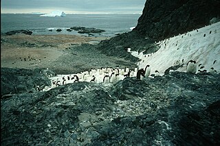
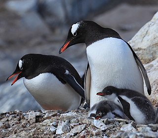
Arthur Harbour is a small harbour entered between Bonaparte Point and Amsler Island on the south-west coast of Anvers Island in the Palmer Archipelago of Antarctica.

Trinity Island or Île de la Trinité or Isla Trinidad is an island 24 km (15 mi) long and 10 km (6 mi) wide in the northern part of the Palmer Archipelago, Antarctica. It lies 37 km (23 mi) east of Hoseason Island, 72.6 km (45 mi) south of Deception Island in the South Shetland Islands, and 10.3 km (6 mi) north-northwest of Cape Andreas on the Antarctic Peninsula. The island was named by Otto Nordenskiöld, leader of the 1901-1904 Swedish Antarctic Expedition (SAE) in commemoration of Edward Bransfield's "Trinity Land" of 1820.

Duke of York Island is a mountainous ice-free island, 2.5 miles (4 km) long, lying in the southern part of Robertson Bay, Antarctica, along the northern coast of Victoria Land. It was first charted in 1899 by the British Antarctic Expedition, under Carsten Borchgrevink, who named it for the then Duke of York, later George V. This island lies situated within the borders known as the Pennell Coast, a portion of Antarctica lying between Cape Williams and Cape Adare.

Snow Hill Island is an almost completely snowcapped island, 33 km (21 mi) long and 12 km (7.5 mi) wide, lying off the east coast of the Antarctic Peninsula. It is separated from James Ross Island to the north-east by Admiralty Sound and from Seymour Island to the north by Picnic Passage. It is one of several islands around the peninsula known as Graham Land, which is closer to Chile, Argentina and South America than any other part of the Antarctic continent.
Emperor Island is a small island in Marguerite Bay, lying close north-east of the Courtier Islands in the Dion Islands. The islands in this group were discovered and roughly charted in 1909 by the French Antarctic Expedition. This island was surveyed in 1948 by the Falkland Islands Dependencies Survey and so named by the UK Antarctic Place-Names Committee because a low rock and shingle isthmus at the south-eastern end of the island was the winter breeding site of emperor penguins.
The Dion Islands are a group of small islands and rocks lying in the northern part of Marguerite Bay, 11 kilometres (6 nmi) south-west of Cape Alexandra, Adelaide Island, off the west coast of the Antarctic Peninsula. They were discovered by the French Antarctic Expedition, 1908–10, and named by Jean-Baptiste Charcot for the Marquis Jules-Albert de Dion, who donated three motor sledges and whose De Dion-Bouton works produced equipment for the expedition.

The Curzon Islands are a small group of rocky islands lying close off Cape Découverte, Adélie Coast. They were probably sighted in January 1840 by a French expedition under Captain Jules Dumont d'Urville, though not identified as islands on d'Urville's maps. The islands were roughly charted in 1912 by Captain J.K. Davis of the Australasian Antarctic Expedition ship Aurora and named by Mawson for Lord Curzon, the President of the Royal Geographical Society, 1911–14. The islands were mapped in detail by the French Antarctic Expedition, 1950–52.
Buchanan Point is a headland 5 km (3.1 mi) north-west of Cape Dundas and 2 km (1.2 mi) south-east of Mackintosh Cove, at the north-eastern end of Laurie Island in the South Orkney Islands of Antarctica.

Gregory Island is a small ice-free island lying just off the east coast of Victoria Land, Antarctica, 5 km (3.1 mi) north-east of Cape Archer and 8 km (5.0 mi) south of Cape Ross. It was discovered by the British National Antarctic Expedition (1901–04), at which time it was thought to be a coastal point and was named "Gregory Point," for John Walter Gregory, director of the civilian staff of the expedition. It was determined to be an island by the British Antarctic Expedition, 1910–13.

Dodman Island is an island in the Biscoe Islands, 6.5 km (4.0 mi) long, lying 7.4 km (4.6 mi) south-east of Rabot Island and 18.5 km (11.5 mi) west of Ferin Head, off the west coast of Graham Land, Antarctica. The island was charted and named by the British Graham Land Expedition, 1934–37, under John Rymill.

Dunlop Island is a rocky island, one nautical mile (2 km) long, lying just off the Wilson Piedmont Glacier and the coast of Victoria Land, close northeast of Cape Dunlop. It was first mapped by the British Antarctic Expedition, 1907–09, under Ernest Shackleton, who named it for H.J.L. Dunlop, chief engineer of the ship Nimrod.

The Edwards Islands are a group of about 20 small islands, mostly ice free in summer, lying off the south-western tip of the Canisteo Peninsula, which projects into the eastern Amundsen Sea between Cranton and Ferrero Bays, on the Walgreen Coast of Marie Byrd Land, Antarctica. They were plotted from air photos taken by U.S. Navy Squadron VX-6 in January 1960, and were named by the Advisory Committee on Antarctic Names for Z T Edwards, chief quartermaster on the USS Glacier during the U.S. Navy Bellingshausen Sea Expedition to this area in February 1960.

Ferguslie Peninsula is a peninsula 2.4 km (1.5 mi) long, lying between Browns Bay and Macdougal Bay on the north coast of Laurie Island, in the South Orkney Islands of Antarctica. The peninsula was charted in 1903 by the Scottish National Antarctic Expedition under William Speirs Bruce, who named it for Ferguslie, the residence of James Coats, chief patron of the expedition.
Haswell Island is the largest of the Haswell Islands, lying off the coast of Antarctica, about 3 kilometres (1.5 nmi) north of Mabus Point in Queen Mary Land. It was discovered by the Western Base Party of the Australasian Antarctic Expedition, 1911–14, under Mawson, and named by him for Professor William A. Haswell, a zoologist at Sydney University and a member of the expedition's Advisory Committee.
Klung Island is the largest island of the Klung Islands lying in Holme Bay, Mac. Robertson Land, Antarctica. It was mapped by Norwegian cartographers from aerial photos taken by the Lars Christensen Expedition, 1936–37, as part of Klungholmane, and was named by the Antarctic Names Committee of Australia after the Klung Islands.

Lagotellerie Island is an island 1.9 kilometres (1 nmi) long, lying 3.7 kilometres (2 nmi) west of Horseshoe Island in Marguerite Bay, off the west coast of Graham Land, Antarctica. It was discovered and named by the French Antarctic Expedition, 1908–10, under Jean-Baptiste Charcot.

The Rosenthal Islands are a group of about islands fringing the west coast of Anvers Island, 11 km (6.8 mi) north of Cape Monaco, in the Palmer Archipelago of Antarctica.

The Lindsey Islands are a group of islands lying by the north-western tip of the Canisteo Peninsula, in the eastern Amundsen Sea between Ferrero and Cranton Bays, on the Walgreen Coast of Marie Byrd Land, Antarctica.

Depot Island is a small granite island lying 2 nautical miles northwest of Cape Ross, off the coast of Victoria Land, Antarctica. It was discovered by the South Magnetic Pole Party of the British Antarctic Expedition, 1907–09 and so named by them because they put a depot of rock specimens on this island.

The Ryder Bay Islands Important Bird Area is a 520 ha designated site on the south-east coast of Adelaide Island, Antarctica. It has been identified as an Important Bird Area (IBA) by BirdLife International because it supports significant numbers of breeding seabirds, notably south polar skuas. The site encompasses the Léonie Islands lying at the mouth of Ryder Bay, as well as Rothera Point, the eastern headland of the bay.


