
The Stancomb-Wills Glacier is a large glacier that debouches into the eastern Weddell Sea southward of Lyddan Island. The glacier was discovered in the course of the U.S. Navy LC-130 plane flight over the coast on November 5, 1967, and was plotted by the United States Geological Survey (USGS) from photographs obtained at that time. The name was applied by the Advisory Committee on Antarctic Names (US-ACAN) in 1969.

The Inaccessible Islands are a group of small precipitous islands ranging from 120 to 215 m high, the westernmost features of the South Orkney Islands, lying 20 km (12 mi) west of Coronation Island in Antarctica. They were discovered in December 1821 by Captain George Powell, a British sealer in the sloop James Monroe, though it is possible they are the "Seal Islands" seen by Nathaniel Palmer a year earlier. The islands were so named by Powell because of their appearance of inaccessibility. They are considered part of the British Antarctic Territory by the United Kingdom and part of the Province of Tierra del Fuego by Argentina.

Snow Hill Island is an almost completely snowcapped island, 33 km (21 mi) long and 12 km (7.5 mi) wide, lying off the east coast of the Antarctic Peninsula. It is separated from James Ross Island to the north-east by Admiralty Sound and from Seymour Island to the north by Picnic Passage. It is one of several islands around the peninsula known as Graham Land, which is closer to South America than any other part of the Antarctic continent.

Smyley Island is an Antarctic island lying off the Antarctic Peninsula. The island is 61 km (38 mi) long and from 13 to 34 km wide, and lies about 20 km (12 mi) north of Case Island. It connects to the Stange Ice Shelf and is separated from Alexander Island by the Ronne Entrance. Smyley Island is one of the 27 islands of Palmer Land, Antarctica.

The Sikorski Glacier is a small glacier in the north-eastern part of the Noville Peninsula, Thurston Island, Ellsworth Land, Antarctica. It flows north-east to the Bellingshausen Sea between Mount Palmer and Mount Feury. It was first roughly delineated from aerial photos taken by the USN's Operation Highjump in 1946–47. It was named by the Advisory Committee on Antarctic Names (US-ACAN) for Stephen Sikorski, electronics technician on USS Glacier, who assisted in setting up an automatic weather station on Thurston Island during the USN's Bellingshausen Sea Expedition in February 1960.

Empereur Island is a rocky island 1.9 kilometres (1 nmi) north of Cape Margerie, lying immediately north of Breton Island in the entrance to Port Martin. It was photographed from the air by U.S. Navy Operation Highjump, 1946–47. It was charted by the French Antarctic Expedition under Andre-Frank Liotard, 1949–51, and so named because the first emperor penguin captured by the expedition was taken on this island.
The Dion Islands are a group of small islands and rocks lying in the northern part of Marguerite Bay, 11 kilometres (6 nmi) south-west of Cape Alexandra, Adelaide Island, off the west coast of the Antarctic Peninsula. They were discovered by the French Antarctic Expedition, 1908–10, and named by Jean-Baptiste Charcot for the Marquis Jules-Albert de Dion, who donated three motor sledges and whose De Dion-Bouton works produced equipment for the expedition.
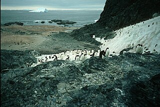
Foyn Island, also known as Svend Foyn Island, is the second largest island in the Possession Islands, East Antarctica, lying 6 kilometres (4 mi) south-west of Possession Island. An Adélie penguin rookery covers much of the island, which is often included in the itinerary of Antarctic cruises.
Bernard Island is a rocky island 400 m long lying 500 m east of the Petrel Island in the Géologie Archipelago of Antarctica. It was charted in 1951 by a French Antarctic Expedition and named by them for Claude Bernard, a noted French physiologist.
The Brownson Islands are a group of about 20 small islands which lie just outside the entrance to Cranton Bay, about 14 nautical miles (26 km) southwest of the southwest tip of the Canisteo Peninsula. They comprises four main islands surrounded by manysmaller islets and rocks, and are largely ice-free in summer. They were delineated from aerial photographs taken by U.S. Navy Operation Highjump in December 1946, and named by the Advisory Committee on Antarctic Names for the USS Brownson, a vessel of the eastern task group of this expedition.

Moe Island is an island 2 km (1.2 mi) long in the South Orkney Islands off Antarctica, separated from the south-west end of Signy Island by Fyr Channel. It was charted by Captain Petter Sørlle in 1912–13, and named after M. Thoralf Moe of Sandefjord, Norway, a contemporary whaling captain who worked in this area. The northernmost point of the island is Spaull Point, named by United Kingdom Antarctic Place-Names Committee (UK-APC) after Vaughan W. Spaull, British Antarctic Survey (BAS) biologist on Signy Island, 1969.

The Géologie Archipelago, also known as the Pointe Géologie Archipelago, Geology Archipelago or Cape Geology Archipelago, is a small archipelago of rocky islands and rocks close to the north of Cape Géodésie and Astrolabe Glacier Tongue, extending from Helene Island on the west to the Dumoulin Islands on the east, in Adélie Land, Antarctica.

Harmony Point is a point which lies close west of Harmony Cove and forms the western extremity of Nelson Island, in the South Shetland Islands of Antarctica. It was charted in 1935 by Discovery Investigations personnel on the Discovery II, and named from association with Harmony Cove.
Haswell Island is the largest of the Haswell Islands, lying off the coast of Antarctica, about 3 kilometres (1.5 nmi) north of Mabus Point in Queen Mary Land. It was discovered by the Western Base Party of the Australasian Antarctic Expedition, 1911–14, under Mawson, and named by him for Professor William A. Haswell, a zoologist at Sydney University and a member of the expedition's Advisory Committee.
Klung Island is the largest island of the Klung Islands lying in Holme Bay, Mac. Robertson Land, Antarctica. It was mapped by Norwegian cartographers from aerial photos taken by the Lars Christensen Expedition, 1936–37, as part of Klungholmane, and was named by the Antarctic Names Committee of Australia after the Klung Islands.

The Mackellar Islands, also MacKellar Islets, are a group of about 30 small islands and rocks lying 3 kilometres (1.5 nmi) north of Cape Denison in the center of Commonwealth Bay, George V Land, Antarctica. They were discovered by the Australasian Antarctic Expedition (1911–14) under Douglas Mawson, who named them for C.D. Mackellar of London, a patron of the expedition. The largest is Greater Mackellar Island.
Macklin Island is a small island in the eastern part of the Robinson Group, about 3 kilometres (1.5 nmi) north of Kirton Island, and 6 kilometres (3 nmi) northwest of Cape Daly, Mac. Robertson Land, Antarctica. It was mapped by Norwegian cartographers from air photos taken by the Lars Christensen Expedition, 1936–37, and was named by the Antarctic Names Committee of Australia for E.L. Macklin, a radio officer at Mawson Station in 1955 and 1959.
Kartografov Island is a small coastal island lying in the western part of the mouth of Harald Bay, Oates Land, Antarctica. It was photographed by U.S. Navy Operation Highjump (1946–47), the Soviet Antarctic Expedition (1957–58) and the Australian National Antarctic Research Expedition (1959). The island was named "Ostrov Kartografov" by the Soviet expedition.

Thurston Glacier is a glacier about 28 km (17 mi) long which drains the south-eastern slopes of Mount Siple on Siple Island. The glacier trends eastward and then east-north-eastward to reach the northern shore of the island. It was mapped by the United States Geological Survey (USGS) from surveys and United States Navy aerial photography, 1959–65.
Lagotellerie Island is an island 1.9 kilometres (1 nmi) long, lying 3.7 kilometres (2 nmi) west of Horseshoe Island in Marguerite Bay, off the west coast of Graham Land, Antarctica. It was discovered and named by the French Antarctic Expedition, 1908–10, under Jean-Baptiste Charcot.
