
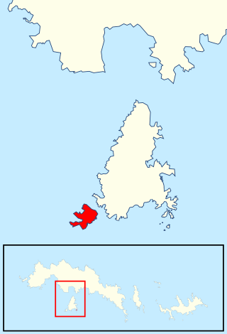
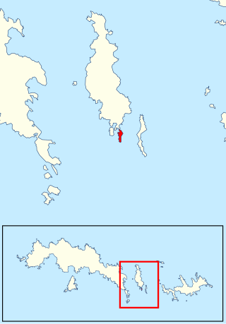
Lynch Island is an island lying in the eastern part of Marshall Bay, close off the south coast of Coronation Island in the South Orkney Islands, Antarctica.
Lynch Island is an island lying in the eastern part of Marshall Bay, close off the south coast of Coronation Island in the South Orkney Islands, Antarctica.
The island was roughly charted in 1912–13 by Petter Sørlle, a Norwegian whaling captain, and surveyed in 1933 by Discovery Investigations personnel. The island was resurveyed in 1948–49 by the Falkland Islands Dependencies Survey and named by the UK Antarctic Place-Names Committee for Thomas Lynch, an American sealer who visited the South Orkney Islands in the schooner Express in 1880. [1]
The island has been designated an Antarctic Specially Protected Area (ASPA 110) for its biological values, especially its relatively luxuriant plant communities. The continent's only two flowering plants, Antarctic hair grass and Antarctic pearlwort, are abundant. The soils associated with the grass swards contain a rich invertebrate fauna. [2]

Signy Island is a small subantarctic island in the South Orkney Islands of Antarctica. It was named by the Norwegian whaler Petter Sørlle (1884–1933) after his wife, Signy Therese.

Coronation Island is the largest of the South Orkney Islands, 25 nautical miles (46 km) long and from 3 to 8 nautical miles wide. The island extends in a general east–west direction, is mainly ice-covered and comprises numerous bays, glaciers and peaks, the highest rising to 1,265 metres (4,150 ft).
The Larsen Islands are a small group of islands north-west of Moreton Point, the western extremity of Coronation Island, in the South Orkney Islands of Antarctica. They were discovered by Captains George Powell and Nathaniel Palmer on the occasion of their joint cruise in December 1821. The islands were named on Petter Sørlle's chart, based upon his survey of the South Orkney Islands in 1912–1913, in honour of Carl Anton Larsen.
Laws Glacier is a confluent glacier system which flows into Marshall Bay on the south coast of Coronation Island, in the South Orkney Islands off Antarctica. It was surveyed in 1948–49 by the Falkland Islands Dependencies Survey (FIDS), and was named by the UK Antarctic Place-Names Committee for Richard M. Laws of the FIDS, leader and biologist at Signy Research Station in 1948 and 1949, and at South Georgia in 1951.

Christoffersen Island is a small island immediately west of the southern end of Powell Island in the South Orkney Islands of Antarctica. The name appears on a chart by Norwegian whaling captain Petter Sorlle, who made a running survey of these islands in 1912–13.

Grey Island is 1 km (0.62 mi) south of Michelsen Island and 2 km (1.2 mi) west of the southern part of Fredriksen Island, in the South Orkney Islands of Antarctica. It was first charted and named Holmen Graa on a map by the Norwegian whaler Captain Petter Sorlle, who made a running survey of the South Orkney Islands in 1912–13. The anglicised form appears on the chart by Discovery Investigations personnel on the Discovery II who surveyed the islands in 1933.
Moe Island is an island 2 km (1.2 mi) long in the South Orkney Islands off Antarctica, separated from the south-west end of Signy Island by Fyr Channel. It was charted by Captain Petter Sørlle in 1912–13, and named after M. Thoralf Moe of Sandefjord, Norway, a contemporary whaling captain who worked in this area. The northernmost point of the island is Spaull Point, named by United Kingdom Antarctic Place-Names Committee (UK-APC) after Vaughan W. Spaull, British Antarctic Survey (BAS) biologist on Signy Island, 1969.

Fredriksen Island is an island 5 km (3.1 mi) long and 1 km (0.62 mi) wide, lying 1 km south-east of Powell Island in the South Orkney Islands of Antarctica. It was discovered by Captains Nathaniel Palmer and George Powell in the course of their joint cruise in December 1821. It was named by Norwegian whaling captain Petter Sorlle, who made a running survey of the island in the 1912–13 summer.

The Géologie Archipelago, also known as the Pointe Géologie Archipelago, Geology Archipelago or Cape Geology Archipelago, is a small archipelago of rocky islands and rocks close to the north of Cape Géodésie and Astrolabe Glacier Tongue, extending from Helene Island on the west to the Dumoulin Islands on the east, in Adélie Land, Antarctica.
The Gneiss Hills are two prominent hills, 270 and 260 metres high, at the west side of McLeod Glacier in the south part of Signy Island, in the South Orkney Islands, Antarctica. They were so named by the Falkland Islands Dependencies Survey, following their survey of 1947, because of a band of pink gneiss outcrops near the summits.
Michelsen Island is a small island in the South Orkney Islands off Antarctica. It is joined to the southern end of Powell Island by a narrow isthmus of occasionally submerged boulders. The island was first observed and roughly mapped in 1821 by Captains George Powell and Nathaniel Palmer. It was named on a map by Captain Petter Sørlle, a Norwegian whaler who made a running survey of the South Orkney Islands in 1912–13.
McLeod Glacier is a glacier 1 nautical mile (2 km) long, flowing in a southeasterly direction into Clowes Bay on the south side of Signy Island, in the South Orkney Islands off Antarctica. It was named by the UK Antarctic Place-Names Committee in 1954 for Michael McLeod, following a survey by the Falkland Islands Dependencies Survey in 1947. On December 12, 1821, the cutter Beaufoy under McLeod sailed to a position at least 60 nautical miles (110 km) west of the South Orkney Islands, where a chart annotation indicates that land was sighted, possibly Coronation Island.
The Menhir is an isolated pinnacle rock, 395 metres (1,300 ft) high, overlooking the west side of Gibbon Bay in eastern Coronation Island, in the South Orkney Islands off Antarctica. It was surveyed by the Falkland Islands Dependencies Survey in 1956–58 and named by the UK Antarctic Place-Names Committee in 1959; a menhir is an upright monumental stone.
Mount Martine is a massive mountain, about 800 metres (2,600 ft) high, with a prominent rocky north face and ice-covered south slopes, overlooking the north shore of Charcot Island, south of Cheesman Island, in the east Bellinghausen Sea of Antarctica.
Matthews Island is the largest of the Robertson Islands in the South Orkney Islands off Antarctica. It lies immediately south-east of Coronation Island, from which it is separated by a narrow channel known as the Divide. Matthews Island was mapped as part of Coronation Island until January 1957 when a Falkland Islands Dependencies Survey (FIDS) party established its insularity. It was named by the UK Antarctic Place-Names Committee in 1959 for Drummond H. Matthews, a FIDS geologist at Signy Island in 1956.
Maling Peak is a mountain 430 metres (1,400 ft) high and is the southernmost of two conspicuous peaks 0.5 nautical miles (1 km) northwest of Cape Vik on the south coast of Coronation Island in the South Orkney Islands, Antarctica. It was roughly surveyed in 1933 by Discovery Investigations personnel and was named by the UK Antarctic Place-Names Committee for Derek H. Maling, a Falkland Islands Dependencies Survey meteorologist at Signy Island in 1948 and 1949, who made a survey triangulation of Signy Island and the south coast of Coronation Island.
Mansfield Point is a point marking the east side of the entrance to Norway Bight on the south coast of Coronation Island, in the South Orkney Islands, Antarctica. It was surveyed by Discovery Investigations personnel in 1933 and by the Falkland Islands Dependencies Survey (FIDS) in 1948–49. The feature was named by the UK Antarctic Place-Names Committee for Arthur W. Mansfield of the FIDS, a meteorologist at Grytviken, South Georgia, in 1951, and leader, meteorologist and biologist at Signy Island in 1952.
The Marion Nunataks are a small group of nunataks rising to about 600 m (2,000 ft) on Charcot Island, in the eastern Bellinghausen Sea of Antarctica. They form a 12 km chain of rocky outcrops on the mid-north coast of the island, stretching from Mount Monique at the western end to Mount Martine in the east.
Lagotellerie Island is an island 1.9 kilometres (1 nmi) long, lying 3.7 kilometres (2 nmi) west of Horseshoe Island in Marguerite Bay, off the west coast of Graham Land, Antarctica. It was discovered and named by the French Antarctic Expedition, 1908–10, under Jean-Baptiste Charcot.
Richardson Cove is a west-facing cove on the southwest side of Moe Island in the South Orkney Islands. The cove, entered between Conroy Point and Corral Point, falls within Antarctic Specially Protected Area No. 109. It was named by the UK Antarctic Place-names Committee in 2006 after Michael George Richardson, Head of Polar Regions Unit, Foreign and Commonwealth Office from 1992 to 2006; British Antarctic Survey (BAS) Biologist, 1970–75; Base Commander, Signy Island (1972–73).
![]() This article incorporates public domain material from "Lynch Island". Geographic Names Information System . United States Geological Survey.
This article incorporates public domain material from "Lynch Island". Geographic Names Information System . United States Geological Survey.
Coordinates: 60°39′S45°36′W / 60.650°S 45.600°W
| | This South Orkney Islands location article is a stub. You can help Wikipedia by expanding it. |