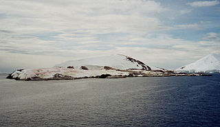
Petermann Island is a small, low and rounded island, lying off the northwest coast of Kiev Peninsula in Graham Land, Antarctica, a short distance south of Booth Island and the Lemaire Channel. It is a popular tourist destination.

Cuverville Island or Île de Cavelier de Cuverville is a dark, rocky island lying in Errera Channel between Arctowski Peninsula and the northern part of Rongé Island, off the west coast of Graham Land in Antarctica. Cuverville Island was discovered by the Belgian Antarctic Expedition (1897–1899) under Adrien de Gerlache, who named it for J.M.A. Cavelier de Cuverville (1834–1912), a vice admiral of the French Navy.
Biscoe Point is a rocky point forming the south-eastern side of Biscoe Bay, immediately north of Access Point on the south side of Anvers Island, in the Palmer Archipelago of Antarctica.

Stonington Island is a rocky island lying 1.8 km (1.1 mi) northeast of Neny Island in the eastern part of Marguerite Bay off the west coast of Graham Land, Antarctica. It is 0.75 km (0.47 mi) long from north-west to south-east and 0.37 km (0.23 mi) wide, yielding an area of 20 ha. It was formerly connected by a drifted snow slope to Northeast Glacier on the mainland. Highest elevation is Anemometer Hill which rises to 25 m (82 ft).

The Dion Islands are a group of small islands and rocks lying in the northern part of Marguerite Bay, 11 kilometres (6 nmi) south-west of Cape Alexandra, Adelaide Island, off the west coast of the Antarctic Peninsula. They were discovered by the French Antarctic Expedition, 1908–10, and named by Jean-Baptiste Charcot for the Marquis Jules-Albert de Dion, who donated three motor sledges and whose De Dion-Bouton works produced equipment for the expedition.
Ablation Point, also known as Punta Ablación, is the eastern extremity of a hook-shaped rock ridge marking the north side of the entrance to Ablation Valley, on the east coast of Alexander Island, Antarctica. It was first photographed from the air on 23 November 1935 by Lincoln Ellsworth and mapped from these photographs by W.L.G. Joerg. It was roughly surveyed in 1936 by the British Graham Land Expedition (BGLE) and resurveyed in 1949 by the Falkland Islands Dependencies Survey (FIDS). It was named by FIDS for nearby Ablation Valley. The site lies within Antarctic Specially Protected Area (ASPA) No.147.

Coppermine Peninsula is the 1.7 km long, 500 m wide and rising to 105 m rugged rocky promontory forming the northwest extremity of Alfatar Peninsula and Robert Island in the South Shetland Islands, Antarctica and lying between English Strait to the west and Carlota Cove to the east. It is linked to Alfatar Peninsula to the southeast by a narrow isthmus bounded by Carlota Cove to the north and the 1 km wide and 460 m indenting Coppermine Cove to the south. The feature is named in association with the adjacent Coppermine Cove, a descriptive name given by sealers in about 1821 from the copper-coloured staining of the lavas and tuffs in the area.
Urchin Rock is a rock, over which the sea breaks, lying 2.3 nautical miles (4.3 km) west of the largest of the Berthelot Islands, off the west coast of Graham Land. First shown on an Argentine government chart of 1957. So named by the United Kingdom Antarctic Place-Names Committee (UK-APC) in 1959 because the rock is a hazard on the edge of Grandidier Channel; an urchin is a roguish or mischievous boy.
Deniau Island is a small island lying midway between Darboux Island and the Lippmann Islands, off the west coast of Graham Land. It was discovered by the French Antarctic Expedition, 1908–10, and named by Jean-Baptiste Charcot for a Monsieur Deniau, a donor of numerous gifts to the expedition.

Murray Island, also sometimes known as Bluff Island, is an island 6 km long lying at the south-west side of Hughes Bay, off the west coast of Graham Land, Antarctica. The feature has been known to sealers operating in the area since the 1820s, although it was shown on charts as part of the mainland. In 1922 the whale catcher Graham passed through the channel separating it from the mainland, proving its insularity. It was named in association with Cape Murray, the seaward extremity of the island.
Mount Monique is a mountain, about 600 m high, with a prominent rocky north face and ice-covered south slopes, at the western end of the Marion Nunataks on the north coast of Charcot Island in the east Bellinghausen Sea of Antarctica.
Midas Island is an island lying north-west of Apéndice Island in Hughes Bay, off the west coast of Graham Land, Antarctica. It was first seen by the Belgian Antarctic Expedition under Gerlache in 1898 and described as an island with two summits "like the ears of an ass". The name, given by the UK Antarctic Place-Names Committee in 1960, derives from this description; Midas, King of Phrygia, was represented in Greek satyric drama with the ears of an ass.
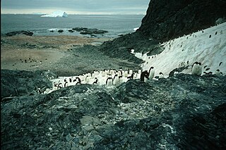
Lagotellerie Island is an island 1.9 kilometres (1 nmi) long, lying 3.7 kilometres (2 nmi) west of Horseshoe Island in Marguerite Bay, off the west coast of Graham Land, Antarctica. It was discovered and named by the French Antarctic Expedition, 1908–10, under Jean-Baptiste Charcot.
South Bay is a 1.7 km wide bay indenting for 2.8 km between Cape Kemp and Py Point on the south-west coast of Doumer Island in the Palmer Archipelago of Antarctica. It was charted by the British Graham Land Expedition in February 1935 and so named from its position on the island. The summer only Yelcho research station, administered by the Chilean Antarctic Institute, stands on the shore of the bay. The eastern part of the bay is designated as Antarctic Specially Protected Area to shield it from accidental interference because it is the subject of a long-term marine ecology research program.

The Cierva Point and offshore islands Important Bird Area is a 6540 ha tract of land and sea on the Danco Coast of the Antarctic Peninsula.

Bablon Island is the ice-free island off the west coast of Barison Peninsula, Graham Coast on the Antarctic Peninsula extending 1.15 km in southeast-northwest direction and 400 m wide. It is lying on the west side of Macrobius Cove and separated from Eijkman Point to the south by a 220 m wide passage.
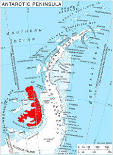
The Ablation Point – Ganymede Heights Antarctic Specially Protected Area is a 180 km2 mountainous tract of land on the eastern side of Alexander Island in the Bellinghausen Sea, west of Palmer Land on the Antarctic Peninsula. It has been designated Antarctic Specially Protected Area (ASPA) No.147 for its geological, geomorphological, glaciological, limnological, and ecological values, and to protect its terrestrial and freshwater ecosystems from uncontrolled human visitation and activity.
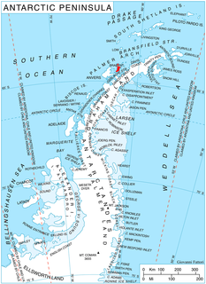
The Eastern Dallmann Bay Antarctic Specially Protected Area is a marine Antarctic Specially Protected Area lying at the eastern end of Dallmann Bay, adjacent to the north-western and northern coasts of Brabant Island in the Palmer Archipelago of Antarctica. With an area of about 676 km2 it covers shallow marine waters that are suitable for bottom trawling for demersal fish and other benthic organisms for scientific research. The area contains important habitat for juvenile fish, especially Black Rockcod and Blackfin Icefish. The fish collected from the site are used in studies of their physiological and biochemical adaptations to low temperatures.

Winkle Island is the island lying between Tula Point and Pickwick Island, Pitt Islands, in the Biscoe Islands. It is separated from Renaud Island to the southwest by Mraka Sound.


