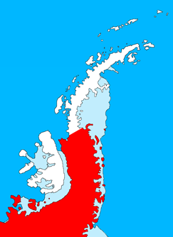
Palmer Land ( 71°30′S065°00′W / 71.500°S 65.000°W ) is the portion of the Antarctic Peninsula, Antarctica that lies south of a line joining Cape Jeremy and Cape Agassiz. This application of Palmer Land is consistent with the 1964 agreement between the Advisory Committee on Antarctic Names and the UK Antarctic Place-Names Committee, in which the name Antarctic Peninsula was approved for the major peninsula of Antarctica, and the names Graham Land and Palmer Land for the northern and southern portions, respectively. The line dividing them is roughly 69° S.
In its southern extreme, the Antarctic Peninsula stretches west, with Palmer Land eventually bordering Ellsworth Land along the 80° W line of longitude. Palmer Land is bounded in the south by the ice-covered Carlson Inlet, an arm of the Filchner-Ronne Ice Shelf, which crosses the 80° W line. This is the base of Cetus Hill.
This feature is named after Nathaniel Palmer, an American sealer who explored the Antarctic Peninsula area southward of Deception Island in the sloop Hero in November 1820. [1]
Mount Jackson is a mountain that dominates the upland of the southern part of the Antarctic Peninsula. It is located in Palmer Land, within the Antarctic claims of Argentina, Chile and the United Kingdom. With an elevation of 3,184 metres (10,446 ft), Mount Jackson was once thought to be the highest mountain in the Antarctic Peninsula and the British Antarctic Territory, before the true height of Mount Hope was measured. Discovered by members of the United States Antarctic Service, 1939–41, it was named for Andrew Jackson, the seventh President of the United States. The first ascent of Mount Jackson was made by a team led by John Crabbe Cunningham of the British Antarctic Survey (BAS) in 1964. Mount Jackson's geology was studied in 1972 as part of the Palmer Island investigations by a team of geologists.
Alexander Island, which is also known as Alexander I Island, Alexander I Land, Alexander Land, Alexander I Archipelago, and Zemlja Alexandra I, is the largest island of Antarctica. It lies in the Bellingshausen Sea west of Palmer Land, Antarctic Peninsula from which it is separated by Marguerite Bay and George VI Sound. The George VI Ice Shelf entirely fills George VI Sound and connects Alexander Island to Palmer Land. The island partly surrounds Wilkins Sound, which lies to its west. Alexander Island is about 390 kilometres (240 mi) long in a north–south direction, 80 kilometres (50 mi) wide in the north, and 240 kilometres (150 mi) wide in the south. Alexander Island is the second-largest uninhabited island in the world, after Devon Island.
Graham Land is the portion of the Antarctic Peninsula that lies north of a line joining Cape Jeremy and Cape Agassiz. This description of Graham Land is consistent with the 1964 agreement between the British Antarctic Place-names Committee and the US Advisory Committee on Antarctic Names, in which the name "Antarctic Peninsula" was approved for the major peninsula of Antarctica, and the names Graham Land and Palmer Land for the northern and southern portions, respectively. The line dividing them is roughly 69 degrees south.
The Hauberg Mountains are a group of mountains of about 35 nautical miles extent, located 12 nautical miles north of Cape Zumberge and 30 nautical miles south of the Sweeney Mountains in eastern Ellsworth Land, Antarctica.
The Usarp Mountains are a major mountain range in North Victoria Land, Antarctica. They are west of the Rennick Glacier and trend north to south for about 190 kilometres (118 mi). The mountains are bounded to the north by Pryor Glacier and the Wilson Hills. They are west of the Bowers Mountains.
Gardner Inlet is a large, ice-filled inlet at the southwest side of Bowman Peninsula, on the east coast of Palmer Land, Antarctica.
Kemp Peninsula is an irregular ice-covered peninsula 26 nautical miles long in a north–south direction and 5 to 12 nautical miles wide. The peninsula rises gently to 305 metres (1,001 ft) and projects east between the heads of Mason Inlet and Mossman Inlet, on the east coast of Palmer Land, Antarctica.
Odom Inlet is an ice-filled inlet 9 nautical miles long, between Cape Howard and Cape MacDonald along the east coast of Palmer Land, Antarctica.
On the continent of Antarctica, the Aramis Range is the third range south in the Prince Charles Mountains, situated 11 miles southeast of the Porthos Range and extending for about 30 miles in a southwest–northeast direction. It was first visited in January 1957 by Australian National Antarctic Research Expeditions (ANARE) southern party led by W.G. Bewsher, who named it for a character in Alexandre Dumas' novel The Three Musketeers, the most popular book read on the southern journey.
Casey Inlet is an ice-filled inlet at the terminus of Casey Glacier, between Miller Point and Cape Walcott, on the east coast of Palmer Land, Antarctica.
Condor Peninsula is a mountainous, ice-covered peninsula, 30 nautical miles long and 10 to 15 nautical miles wide, between Odom Inlet and Hilton Inlet on the east coast of Palmer Land, Antarctica.
Welch Mountains is a group of mountains that dominate the area, the highest peak rising to 3,015 metres (9,892 ft), located 25 nautical miles north of Mount Jackson on the east margin of the Dyer Plateau of Palmer Land, Antarctica
Kvinge Peninsula is a snow-covered peninsula at the north side of Palmer Inlet terminating in Cape Bryant, on the east coast of Palmer Land, Antarctica.
Mobiloil Inlet is an ice-filled inlet, nurtured by several northeast and east flowing glaciers, lying between the Rock Pile Peaks and Hollick-Kenyon Peninsula along the east coast of the Antarctic Peninsula.
The Morozumi Range is a mountain range in the Usarp Mountains of North Victoria Land, Antarctica. It extends northwest–southeast for 25 miles (40 km), with its northern elevations overlooking the convergence of Gressitt Glacier and Rennick Glacier.
Hughes Ice Piedmont is the ice piedmont between Cordini Glacier and Smith Inlet on the east coast of Palmer Land, Antarctica.
Hilton Inlet is an ice-filled inlet, 12 nautical miles wide, which recedes about 22 nautical miles west from its entrance between Cape Darlington and Cape Knowles, along the east coast of Palmer Land, Antarctica.
Lehrke Inlet is an ice-filled inlet, 8 nautical miles wide, which recedes southwest for 17 nautical miles between Cape Boggs and Cape Sharbonneau, along the east coast of Palmer Land, Antarctica.
The Columbia Mountains are a group of largely bare rock peaks, ridges and nunataks located near the east margin of the Dyer Plateau, 20 nautical miles south-east of the Eternity Range, in Palmer Land, Antarctica.