
The Filchner–Ronne Ice Shelf or Ronne–Filchner Ice Shelf is an Antarctic ice shelf bordering the Weddell Sea.

Alexander Island, which is also known as Alexander I Island, Alexander I Land, Alexander Land, Alexander I Archipelago, and Zemlja Alexandra I, is the largest island of Antarctica. It lies in the Bellingshausen Sea west of Palmer Land, Antarctic Peninsula from which it is separated by Marguerite Bay and George VI Sound. The George VI Ice Shelf entirely fills George VI Sound and connects Alexander Island to Palmer Land. The island partly surrounds Wilkins Sound, which lies to its west. Alexander Island is about 390 kilometres (240 mi) long in a north–south direction, 80 kilometres (50 mi) wide in the north, and 240 kilometres (150 mi) wide in the south. Alexander Island is the second-largest uninhabited island in the world, after Devon Island.
The Hauberg Mountains are a group of mountains of about 35 nautical miles extent, located 12 nautical miles north of Cape Zumberge and 30 nautical miles south of the Sweeney Mountains in eastern Ellsworth Land, Antarctica.
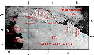
The Abbot Ice Shelf is an ice shelf 250 nautical miles long and 40 nautical miles wide, bordering Eights Coast from Cape Waite to Pfrogner Point in Antarctica. Thurston Island lies along the northern edge of the western half of this ice shelf; other sizable islands lie partly or wholly within this shelf.

The Brunt Ice Shelf borders the Antarctic coast of Coats Land between Dawson-Lambton Glacier and Stancomb-Wills Glacier Tongue. It was named by the UK Antarctic Place-names Committee after David Brunt, British meteorologist, Physical Secretary of the Royal Society, 1948–57, who was responsible for the initiation of the Royal Society Expedition to this ice shelf in 1955.
Smith Glacier (75°05′S112°00′W is a low-gradient Antarctic glacier, over 160 km long, draining from Toney Mountain in an ENE direction to Amundsen Sea. A northern distributary, Kohler Glacier, drains to Dotson Ice Shelf but the main flow passes to the sea between Bear Peninsula and Mount Murphy, terminating at Crosson Ice Shelf.

The Getz Ice Shelf is an ice shelf over 300 nautical miles long and from 20 to 60 nautical miles wide, bordering the Hobbs Coast and Bakutis Coast of Marie Byrd Land, Antarctica, between the McDonald Heights and Martin Peninsula. Several large islands are partially or wholly embedded in the ice shelf.
The Gould Coast is a portion of the coast of Antarctica along the eastern margin of the Ross Ice Shelf at Amundsen Coast between the west side of Scott Glacier and the south end of the Siple Coast. It was named by the New Zealand Antarctic Place-Names Committee in 1961 for Laurence M. Gould, a geologist who was second-in-command of the Byrd Antarctic Expedition, 1928–30. Gould led the Geological Party which in 1929 mapped 175 miles (280 km) of this coast. While president of Carleton College, Northfield, Minnesota, he was appointed Chairman of the U.S. National Committee for the International Geophysical Year and took a prominent part in planning the United States research program for Antarctica.

Veststraumen Glacier is a glacier about 45 miles long draining west along the south end of Kraul Mountains into Riiser-Larsen Ice Shelf. The glacier was seen in the course of a U.S. Navy LC-130 plane flight over the coast on November 5, 1967, and was plotted by the United States Geological Survey (USGS) from photographs obtained at that time. In 1969, the Advisory Committee on Antarctic Names (US-ACAN) gave the name "Endurance Glacier" to this feature, but that naming was rescinded because UK Antarctic Place-Names Committee (UK-APC) gave the identical name to a small glacier on Elephant Island. The descriptive name "Veststraumen" appears on a 1972 Norsk Polarinstitutt map.
Fowler Ice Rise is a very large Antarctic ice rise between Evans Ice Stream and Carlson Inlet, in the southwest part of the Ronne Ice Shelf. The feature appears to be completely ice-covered except for the Haag Nunataks, which protrude above the surface in the northwestern portion. It was mapped by the United States Geological Survey from Landsat imagery taken 1973–74, and named by the Advisory Committee on Antarctic Names for Captain Alfred N. Fowler, U.S. Navy, Commander of the U.S. Naval Support Force, Antarctica, 1972–74.
The Evans Ice Stream is a large ice stream draining from Ellsworth Land, between Cape Zumberge and Fowler Ice Rise, into the western part of the Ronne Ice Shelf. Mills Glacier flows adjacently into the ice stream from the southwest side. The feature was recorded on February 5, 1974, in Landsat imagery. It was named by the UK Antarctic Place-Names Committee for Stanley Evans, a British physicist who, starting in 1961, developed apparatus for radio echo sounding of icecaps and glaciers from aircraft; he carried out upper atmosphere research at Brunt Ice Shelf, 1956–57.
Gardner Inlet is a large, ice-filled inlet at the southwest side of Bowman Peninsula, on the east coast of Palmer Land, Antarctica.
Eights Coast is a portion of the coast of West Antarctica, between Cape Waite and Pfrogner Point. To the west is the Walgreen Coast, and to the east is the Bryan Coast. It is part of Ellsworth Land and stretches between 103°24'W and 89°35'W. This coast is bordered by Thurston Island, Abbot Ice Shelf and some islands within the ice shelf, and for most of its length touches the Bellingshausen Sea. Most of Eights Coast is not claimed by any nation. In the east, Eights Coast borders the sector claimed by Chile as part of its southernmost province. Peter I Island, 450 kilometers north of the coast, is claimed by Norway as a dependency.
Minna Bluff is a narrow, bold peninsula, 25 nautical miles long and 3 nautical miles wide, projecting southeast from Mount Discovery into the Ross Ice Shelf, Antarctica. It was discovered by the British National Antarctic Expedition (1901-04) which named it for Minna, the wife of Sir Clements Markham, the "father" of the expedition. It culminates in a south-pointing hook feature, and is the subject of research into Antarctic cryosphere history, funded by the National Science Foundation, Office of Polar Programs.
Lazarev Bay is a rectangular bay, 15 nautical miles (28 km) long and 13 nautical miles (24 km) wide, which separates Alexander Island from Rothschild Island and is bounded on the south side by the Wilkins Ice Shelf, which joins the east portion of Rothschild Island and the west portion of Alexander Island. Two minor islands, Dint Island and Umber Island, lie merged within the ice of the Wilkins Ice Shelf within Lazarev Bay.
Mercer Ice Stream, formerly Ice Stream A, flows west to Gould Coast to the south of Whillans Ice Stream, Antarctica. It is the southernmost of several major ice streams draining from Marie Byrd Land into the Ross Ice Shelf. The ice streams were investigated and mapped by U.S. Antarctic Research Program personnel in a number of field seasons from 1983–84 and named Ice Stream A, B, C, etc., according to their position from south to north. The name was changed by the Advisory Committee on Antarctic Names in 2002 to honor Quaternary geologist John H. Mercer (1922–87) of the Institute of Polar Studies, Ohio State University, who mapped the moraines above Reedy Glacier and in the Ohio Range at the head of Horlick Ice Stream, the major tributaries to Mercer Ice Stream.
Fletcher Ice Rise, or Fletcher Promontory, is a large ice rise, 100 miles (160 km) long and 40 miles (64 km) wide, at the southwest side of the Ronne Ice Shelf, Antarctica. The feature is completely ice covered and rises between Rutford Ice Stream and Carlson Inlet. The ice rise was observed, photographed and roughly sketched by Lieutenant Ronald F. Carlson, U.S. Navy, in the course of a C-130 aircraft flight of December 14–15, 1961 from McMurdo Sound to this vicinity and returning. It was mapped in detail by the U.S. Geological Survey from Landsat imagery taken 1973–74, and was named by the Advisory Committee on Antarctic Names for Joseph O. Fletcher, director of the Office of Polar Programs, National Science Foundation, 1971–74.
Bryan Coast is that portion of the coast of Antarctica along the south shore of the Bellingshausen Sea between Pfrogner Point and the northern tip of the Rydberg Peninsula. To the west is Eights Coast, and to the east is English Coast.

The Lassiter Coast is the portion of the east coast of the Antarctic Peninsula that extends from Cape Mackintosh to Cape Adams. The northern portion of this coast was discovered and photographed from the air by the United States Antarctic Service in 1940. During 1947 the entire extent of the coast was photographed from the air by the Ronne Antarctic Research Expedition (RARE) under Finn Ronne, who in conjunction with the Falkland Islands Dependencies Survey charted it from the ground.

Aster Glacier is an Antarctic glacier descending the east slope of Craddock Massif and flowing between Elfring Peak and Willis Ridge to Thomas Glacier in the Sentinel Range, Ellsworth Mountains in Antarctica. It was named by the Advisory Committee on Antarctic Names in 2006, after Richard Aster, Professor of Geophysics and Department Head of Geosciences at Colorado State University, whose research in Antarctica includes volcanological studies at the Mount Erebus volcano observatory on Ross Island, glaciological, oceanic, and tectonic seismic source studies, seismic tomography, ice shelf studies, and the coupling of solid Earth geophysics and Antarctic ice sheet evolution.

