Joinville Island is the largest island of the Joinville Island group, about 40 nautical miles long in an east–west direction and 12 nautical miles wide, lying off the northeastern tip of the Antarctic Peninsula, from which it is separated by the Antarctic Sound.

Loubet Coast is the portion of the west coast of Graham Land in Antarctic Peninsula, extending 158 km between Cape Bellue to the northeast and Bourgeois Fjord to the southwest. South of Loubet Coast is Fallières Coast, north is Graham Coast.
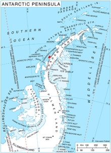
Mikkelsen Bay is a bay, 15 nautical miles wide at its mouth and indenting 10 nautical miles, entered between Bertrand Ice Piedmont and Cape Berteaux along the west coast of Graham Land, Antarctica.
Northeast Glacier is a steep, heavily crevassed glacier, 13 nautical miles long and 5 nautical miles wide at its mouth, which flows from McLeod Hill westward and then south-westwards into Marguerite Bay between the Debenham Islands and Roman Four Promontory, on the west coast of Graham Land, Antarctica.
Rymill Bay is a bay, 9 nautical miles wide at its mouth and indenting 5 nautical miles between Red Rock Ridge and Bertrand Ice Piedmont along the west coast of Graham Land, Antarctica.
Hanusse Bay is a broad, V-shaped bay, off the west coast of Graham Land, Antarctica. The bay is 37 kilometres (20 nmi) long and trends generally north–south. It is bordered by Cape Mascart on Anvers Island, and Shmidt Point on Arrowsmith Peninsula, Loubet Coast. At its north entrance, Isacke Passage separates it from Liard Island. It is bounded to the south by a line from Landauer Point, the north point of Hansen Island and Bagnold Point on Arrowsmith Peninsula.
Hadley Upland is a triangular shaped remnant plateau with an undulating surface, 1,500 to 1,900 metres, in southern Graham Land, Antarctica. It is bounded by Windy Valley and Martin Glacier, Gibbs Glacier and Lammers Glacier.
Alencar Peak is a 1,555-metre (5,100 ft) peak at the head of Lind Glacier, standing 6 nautical miles (11 km) east of Cape Perez on the west side of Graham Land in Antarctica. It was discovered by the French Antarctic Expedition of 1908–10 under Jean-Baptiste Charcot and was named by him for Admiral Alexandrino Faria de Alencar, a Brazilian Navy Minister at the time.

Graham Coast is the portion of the west coast of Graham Land in Antarctic Peninsula, extending 172 km between Cape Bellue to the southwest and Cape Renard to the northeast.

Owlshead Peak is a peak 1.5 nautical miles (2.8 km) east of Cape Bellue on Stresher Peninsula on the west coast of Graham Land. Photographed by the Falkland Islands and Dependencies Aerial Survey Expedition (FIDASE) in 1956–57, and roughly surveyed by the Falkland Islands Dependencies Survey FIDS from "Detaille Island", 1956-59. The name is descriptive of the feature when seen from Crystal Sound and Darbel Bay.
Waldeck-Rousseau Peak is a conspicuous monolith 3 nautical miles (6 km) east-northeast of Cape Evensen on Stresher Peninsula on Graham Coast, Antarctic Peninsula. The French Antarctic Expedition (1903–05) under Jean-Baptiste Charcot charted a cape in this area which they named for French statesman Pierre Waldeck-Rousseau. On re-exploring this area, the French Antarctic Expedition (1908–10) under Charcot sighted the feature from Pendleton Strait, 25 nautical miles (46 km) distant, and charted it as an island near the coast. Correlating its work with that of Charcot, the British Graham Land Expedition (BGLE) under John Rymill charted this portion of the coast by land and from the air in 1935. Waldeck-Rousseau Peak as here applied is in accord with the interpretation of the BGLE.
Darbel Bay is a bay 25 nautical miles (50 km) wide, indenting the west coast of Graham Land between Stresher Peninsula and Pernik Peninsula. Entered southwest of Cape Bellue and northeast of Cape Rey. The glaciers Widmark Ice Piedmont, Cardell, Erskine, Hopkins, Drummond, Widdowson, McCance, Solun, and Škorpil feed the bay.
The Darbel Islands are a group of islands and rocks extending southwest from Cape Bellue for 5 nautical miles (9 km) across the entrance to Darbel Bay, off the west coast of Graham Land. They were charted in 1930 by Discovery Investigations personnel on the Discovery II and named Marin Darbel Islands after the bay in which they were found. Both names have since been shortened by the UK Antarctic Place-Names Committee.
Deliverance Point is a rocky point 2.5 nautical miles (5 km) south of Cape Tuxen on the west coast of Graham Land. It was discovered by the French Antarctic Expedition, 1908–10, under Jean-Baptiste Charcot, and was so named because Charcot and two companions were rescued here after being separated from the ship Pourquoi-Pas? for several days, while on an exploration of the area in a small boat.
Doyle Glacier is a glacier flowing to the west coast of Graham Land on both sides of Prospect Point. It was charted by the British Graham Land Expedition under John Rymill, 1934–37, and was named by the UK Antarctic Place-Names Committee in 1959 for Sir Arthur Conan Doyle, the first Englishman to make a full day's journey on skis, in March 1893.
Cape Evensen is a cape forming the north side of the entrance to Auvert Bay, on the northwest coast of Stresher Peninsula, Graham Land in Antarctica. It was discovered by the French Antarctic Expedition, 1903–05, and named by Jean-Baptiste Charcot for Captain C.J. Evensen of the Hertha, who explored along the west coast of the Antarctic Peninsula in 1893.
Mouillard Glacier is a glacier flowing into the southeast corner of Brialmont Cove, on the west coast of Graham Land, Antarctica. It was photographed by the Falkland Islands and Dependencies Aerial Survey Expedition in 1956–57, and mapped from these photos by the Falkland Islands Dependencies Survey. The glacier was named by the UK Antarctic Place-Names Committee in 1960 for Louis P. Mouillard, a French pioneer of gliding flight.
Lumière Peak is a peak, 1,065 metres (3,500 ft) high, standing 3 nautical miles (6 km) southeast of Cape Tuxen on the west coast of Graham Land, Antarctica. It was discovered by the Third French Antarctic Expedition, 1903–05, and named by Jean-Baptiste Charcot for Louis Lumière, a leader in photographic research and development in France at that time.
Stresher Peninsula is the predominantly ice-covered rectangular peninsula 30 km wide and projecting 24 km northwestwards from Graham Land, Antarctic Peninsula. It is bounded by Holtedahl Bay to the northeast, Auvert Bay to the northwest and Darbel Bay to the southwest. Its west extremity Cape Bellue separates Graham Coast to the northeast from Loubet Coast to the southwest. Lawson Peak is a peak 3.5 nautical miles (6 km) southeast of Cape Evensen.
Gomotartsi Knoll is the rocky, mostly ice-covered peak of elevation 942 m in the south part of Widmark Ice Piedmont on Stresher Peninsula, Loubet Coast in Graham Land, Antarctica. It is named after the settlement of Gomotartsi in Northwestern Bulgaria.