External links
- The Australian Antarctic Data Centre website
- The Australian Antarctic Division website
- The World Wide Science website
The Australian Antarctic Data Centre is a section of the Australian Antarctic Division, which forms part of the Australian Government, Commonwealth of Australia, in the Department of the Environment and Energy.
AADC services form the backbone of data collection and data management in Australia's Antarctic Science Program.
The AADC undertakes its role in alignment with the National Antarctic data management policy.
Scientific data are key (and highly valuable) outputs of Australia's Antarctic Science Program and therefore should be managed for posterity.
Article III.1.c of the Antarctic Treaty states that "to the greatest extent feasible and practicable" ... "scientific observations and results from Antarctica shall be exchanged and made freely available"
The Australian Antarctic Data Centre participates in the WorldWideScience global science gateway.
The Australian Antarctic Division (AAD) is a division of the Department of Climate Change, Energy, the Environment and Water. The Division undertakes science programs and research projects to contribute to an understanding of Antarctica and the Southern Ocean. It conducts and supports collaborative research programs with other Australian and international organisations, such as the Bureau of Meteorology and Geoscience Australia, as well as administering and maintaining a presence in Australian Antarctic and sub-Antarctic territories.

The Davis Station, commonly called Davis, is one of three permanent bases and research outposts in Antarctica managed by the Australian Antarctic Division (AAD). Davis is situated on the coast of Cooperation Sea in Princess Elizabeth Land, Ingrid Christensen Coast in the Australian Antarctic Territory, a territory claimed by Australia. Davis lies in the Antarctic oasis, a remarkable ice free area known as the Vestfold Hills.

The Mawson Station, commonly called Mawson, is one of three permanent bases and research outposts in Antarctica managed by the Australian Antarctic Division (AAD). Mawson lies in Holme Bay in Mac. Robertson Land, East Antarctica in the Australian Antarctic Territory, a territory claimed by Australia. Established in 1954, Mawson is Australia's oldest Antarctic station and the oldest continuously inhabited Antarctic station south of the Antarctic Circle.

The Institute of Cetacean Research: is a Japanese entity that claims to be a research organization specializing in the "biological and social sciences related to whales".

Geomatics is defined in the ISO/TC 211 series of standards as the "discipline concerned with the collection, distribution, storage, analysis, processing, presentation of geographic data or geographic information". Under another definition, it consists of products, services and tools involved in the collection, integration and management of geographic (geospatial) data. It is also known as geomatic(s) engineering. Surveying engineering was the widely used name for geomatic(s) engineering in the past.
The Australian Department of the Environment was a department of the Government of Australia that existed between September 2013 and July 2016. The department was charged with responsibility for developing and implementing national policy, programs and legislation to protect and conserve Australia's environment and heritage.

The United States Antarctic Program is an organization of the United States government which has presence in the Antarctica continent. Founded in 1959, the USAP manages all U.S. scientific research and related logistics in Antarctica as well as aboard ships in the Southern Ocean.
The Integrated Ocean Drilling Program (IODP) was an international marine research program. The program used heavy drilling equipment mounted aboard ships to monitor and sample sub-seafloor environments. With this research, the IODP documented environmental change, Earth processes and effects, the biosphere, solid earth cycles, and geodynamics.

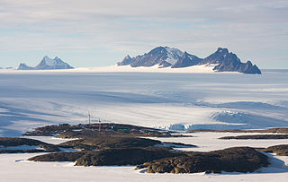
The Scullin Monolith is a crescent-shaped rock fronting the sea 6 km (3.7 mi) west of the similar Murray Monolith, and 8 km (5.0 mi) from Torlyn Mountain, in Mac. Robertson Land, Antarctica. It is a steep massif of metasedimentary gneiss and granitic origin, with the adjacent coastline consisting of 40 m high ice cliffs. The monolith rises steeply to extend from 435 m high Mikkelsen Peak westward in a crescent that forms Douglas Bay.
The Vestfold Hills are rounded, rocky, coastal hills, 411 square kilometres (159 sq mi) in extent, on the north side of Sorsdal Glacier on the Ingrid Christensen Coast of Princess Elizabeth Land, Antarctica. The hills are subdivided by three west-trending peninsulas bounded by narrow fjords. Most of the hills range between 30 and 90 metres in height, with the highest summit reaching nearly 160 metres (520 ft).

The New South Wales Office of Environment and Heritage (OEH), a former division of the Government of New South Wales between April 2011 and July 2019, was responsible for the care and protection of the environment and heritage, which includes the natural environment, Aboriginal country, culture and heritage, and built heritage in New South Wales, Australia. The OEH supported the community, business and government in protecting, strengthening and making the most of a healthy environment and economy within the state. The OEH was part of the Department of Planning and Environment cluster and managed national parks and reserves.

The Australian Minister for the Environment and Water is a position which is currently held by Tanya Plibersek in the Albanese ministry since 1 June 2022, following the Australian federal election in 2022.

The Macquarie Island Station is a permanent Australian subantarctic research base on Macquarie Island, commonly called Macca, situated in the Southern Ocean and located approximately halfway between mainland Australia and Antarctica, managed by the Australian Antarctic Division (AAD). The station lies at the base of Wireless Hill, between two bays on the isthmus at the northern end of the island.

Murray Monolith is a detached part of Torlyn Mountain in Mac.Robertson Land, Antarctica. It is a steep massif of metasedimentary gneiss and granitic origin, with the adjacent coastline consisting of 40 m high ice cliffs. The monolith is dome-shaped with steep sides, rising to a seaward summit of 339 m and an inland summit of 363 m at Torlyn Mountain.

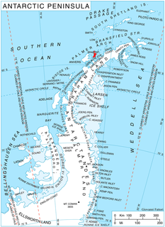
Kran Peninsula is the heavily indented peninsula forming the northeast extremity of Liège Island in the Palmer Archipelago, Antarctica. It extends 2.85 km in north-south direction and 2.35 km in east-west direction, ending up in Moureaux Point to the north and Neyt Point to the east, and connected to the rest of the island by a 200 m wide neck to the south.

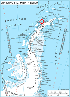
Buragara Cove is the 2.08 km wide cove indenting for 1.4 km the west coast of Brabant Island in the Palmer Archipelago, Antarctica. It is part of Dallmann Bay, entered northeast of Zabel Point and southwest of Devene Point. The feature was formed near the start of the 21st century as a result of the retreat of Rush Glacier, which feeds its head.
The Marine Ecosystem Assessment for the Southern Ocean (MEASO) is a project led by researchers at the Antarctic Climate & Ecosystems Cooperative Research Centre as a part of an international project of Integrating Climate and Ecosystem Dynamics (ICED).

In common with many of the expeditions of the Heroic Age, Douglas Mawson's Australasian Antarctic Expedition (AAE) employed dog-hauled sledges as a principal means of transportation during exploration of the continent. Dog sledges could carry more weight and travel faster than man-hauled sledges; they were more reliable in the freezing temperatures than motor-sledges; and dogs had proved to be more adaptable to harsh Antarctic conditions than ponies.

Waterhouse Island is an island in Prydz Bay on the Ingrid Christensen Coast of Princess Elizabeth Land, Antarctica. It lies just SSW of Lugg Island, and about 3.5 km NNW of Australia's Davis Station on Broad Peninsula in the Vestfold Hills. It was named after R.S. Waterhouse, a Medical Officer at Davis in 1971.

The Donskiye Islands form a small archipelago, including Warriner Island and Redfearn Island, off Breidnes Peninsula in the Vestfold Hills of Princess Elizabeth Land, Antarctica.