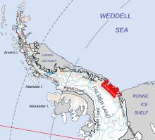
The Filchner–Ronne Ice Shelf or Ronne–Filchner Ice Shelf is an Antarctic ice shelf bordering the Weddell Sea.

Thurston Island is a largely ice-covered, glacially dissected island, 135 nautical miles long and 55 nautical miles wide, lying between between Amundsen Sea and Bellingshausen Sea a short way off the northwest end of Ellsworth Land, Antarctica. The island is separated from the mainland by Peacock Sound, which is occupied by the west portion of Abbot Ice Shelf.
The Hauberg Mountains are a group of mountains of about 35 nautical miles extent, located 12 nautical miles north of Cape Zumberge and 30 nautical miles south of the Sweeney Mountains in eastern Ellsworth Land, Antarctica.
The Scaife Mountains is a group of mountains rising west of Prehn Peninsula and between the Ketchum Glacier and Ueda Glacier, at the base of the Antarctic Peninsula.
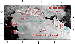
The Abbot Ice Shelf is an ice shelf 250 nautical miles long and 40 nautical miles wide, bordering Eights Coast from Cape Waite to Pfrogner Point in Antarctica. Thurston Island lies along the northern edge of the western half of this ice shelf; other sizable islands lie partly or wholly within this shelf.

The Getz Ice Shelf is an ice shelf over 300 nautical miles long and from 20 to 60 nautical miles wide, bordering the Hobbs Coast and Bakutis Coast of Marie Byrd Land, Antarctica, between the McDonald Heights and Martin Peninsula. Several large islands are partially or wholly embedded in the ice shelf.
Gardner Inlet is a large, ice-filled inlet at the southwest side of Bowman Peninsula, on the east coast of Palmer Land, Antarctica.
Kemp Peninsula is an irregular ice-covered peninsula 26 nautical miles long in a north–south direction and 5 to 12 nautical miles wide. The peninsula rises gently to 305 metres (1,001 ft) and projects east between the heads of Mason Inlet and Mossman Inlet, on the east coast of Palmer Land, Antarctica.
The Hollick-Kenyon Peninsula(68°35′S63°50′W) is an ice-covered spur from the main mountain mass of the Antarctic Peninsula. It projects over 40 nautical miles in a northeasterly arc from its base between Mobiloil Inlet and Casey Inlet.
King Peninsula is an ice-covered peninsula, 100 nautical miles long and 20 nautical miles wide, lying south of Thurston Island and forming the south side of Peacock Sound, Antarctica. It projects from the continental ice sheet and trends west between the Abbot Ice Shelf and Cosgrove Ice Shelf to terminate at the Amundsen Sea.
New Bedford Inlet is a large pouch-shaped, ice-filled embayment between Cape Kidson and Cape Brooks, along the east coast of Palmer Land, Antarctica.
Wright Inlet is an ice-filled inlet receding westward between Cape Little and Cape Wheeler along the east coast of Palmer Land, Antarctica.
Bryan Coast is that portion of the coast of Antarctica along the south shore of the Bellingshausen Sea between Pfrogner Point and the northern tip of the Rydberg Peninsula. To the west is Eights Coast, and to the east is English Coast.
Carroll Inlet is an inlet, 40 nautical miles long and 6 nautical miles wide, trending southeast along the coast of Ellsworth Land, Antarctica, between the Rydberg Peninsula and Smyley Island. The head of the inlet is divided into two arms by the presence of Case Island and is bounded to the east by Stange Ice Shelf.
Condor Peninsula is a mountainous, ice-covered peninsula, 30 nautical miles long and 10 to 15 nautical miles wide, between Odom Inlet and Hilton Inlet on the east coast of Palmer Land, Antarctica.
Piggott Peninsula is a broad snow-covered peninsula between New Bedford Inlet and Wright Inlet on Lassiter Coast, Palmer Land, Antarctica. It is bounded to the west by Bryan Glacier and Swann Glacier.
Hilton Inlet is an ice-filled inlet, 12 nautical miles wide, which recedes about 22 nautical miles west from its entrance between Cape Darlington and Cape Knowles, along the east coast of Palmer Land, Antarctica.
The Hutton Mountains are a group of mountains in southeast Palmer Land, Antarctica, bounded on the southwest by Johnston Glacier, on the northwest by Squires Glacier, on the north by Swann Glacier, and on the east by Keller Inlet.

Stange Sound is a sound about 60 nautical miles long and 25 nautical miles wide along the coast of Ellsworth Land, Antarctica. An ice shelf occupies the sound, which is bounded on the west by Smyley Island and Case Island, on the south by the mainland, on the east by Spaatz Island and on the north by open water in the Ronne Entrance. Photographed from the air and roughly plotted by the Ronne Antarctic Research Expedition under Finn Ronne. Named for Henry Stange of New York, a contributor to RARE who gave much time to assisting in preparations for the expedition.
The Smith Peninsula is an ice-covered, "dog-legged" peninsula 25 nautical miles long and 10 nautical miles wide, extending in an easterly direction between Keller Inlet and Nantucket Inlet from the east coast of Palmer Land, Antarctica.