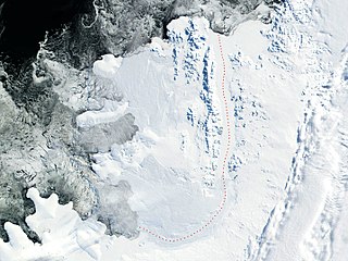
Alexander Island, which is also known as Alexander I Island, Alexander I Land, Alexander Land, Alexander I Archipelago, and Zemlja Alexandra I, is the largest island of Antarctica. It lies in the Bellingshausen Sea west of Palmer Land, Antarctic Peninsula from which it is separated by Marguerite Bay and George VI Sound. The George VI Ice Shelf entirely fills George VI Sound and connects Alexander Island to Palmer Land. The island partly surrounds Wilkins Sound, which lies to its west. Alexander Island is about 390 kilometres (240 mi) long in a north–south direction, 80 kilometres (50 mi) wide in the north, and 240 kilometres (150 mi) wide in the south. Alexander Island is the second-largest uninhabited island in the world, after Devon Island.

Tower Island is an Antarctic island 9 kilometres (5 nmi) long and 305 m (1,001 ft) high. It marks the north-east extent of Palmer Archipelago. It lies 37 kilometres (20 nmi) north-east of Trinity Island, separated by Gilbert Strait. Both islands are separated from the Davis Coast to the south by Orléans Strait, running northeast–southwest. The Pearl Rocks lie off the West Coast of Tower Island.

The Beethoven Peninsula is a deeply indented, ice-covered peninsula, 60 miles (100 km) long in a northeast–southwest direction and 60 miles (100 km) wide at its broadest part, forming the southwest part of Alexander Island, which lies off the southwestern portion of the Antarctic Peninsula. The south side of the peninsula is supported by the Bach Ice Shelf whilst the north side of the peninsula is supported by the Wilkins Ice Shelf. The Mendelssohn Inlet, the Brahms Inlet and the Verdi Inlet apparently intrude into it. The Bach Ice Shelf, Rossini Point and Berlioz Point are some distance away, on the Ronne Entrance from the Southern Ocean. Beethoven Peninsula is one of the eight peninsulas of Alexander Island.

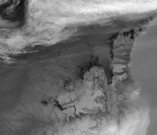
Adelaide Island is a large, mainly ice-covered island, 139 kilometres (75 nmi) long and 37 kilometres (20 nmi) wide, lying at the north side of Marguerite Bay off the west coast of the Antarctic Peninsula. The Ginger Islands lie off the southern end. Mount Bodys is the easternmost mountain on Adelaide Island, rising to over 1,220 m. The island lies within the Argentine, British and Chilean Antarctic claims.
Charcot Island or Charcot Land is an island administered under the Antarctic Treaty System, 56 kilometres (30 nmi) long and 46 kilometres (25 nmi) wide, which is ice covered except for prominent mountains overlooking the north coast. Charcot Island lies within the Bellingshausen Sea, 102 kilometres (55 nmi) west of Alexander Island, and about 57 kilometres (31 nmi) north of Latady Island. A notable landmark of the island is its northernmost point, Cape Byrd.

Renaud Island is an ice-covered island in the Biscoe Islands of Antarctica, 40 km (25 mi) long and from 6.4 to 16.1 km wide, lying between the Pitt Islands and Rabot Island. It is separated from the Pitt Islands to the northeast by Mraka Sound, and from Lavoisier Island to the southwest by Pendleton Strait.
Nelson Rock is an uninhabited solitary island, being essentially a dark rock which is partly ice-covered and lies 5.6 km (3 nmi) north of Williams Rocks, off the coast of Mac Robertson Land in Holme Bay. The Rock was mapped by Robert G. Dovers of the Australian National Antarctic Research Expeditions (ANARE) in 1954. Nelson Rock was named by the Antarctic Names Committee of Australia (ANCA) for Robert Edward Kelvin Nelson, a weather observer at Mawson Station in 1962, who assisted with the triangulation of Nelson Rock and the erection of a beacon.
Gardner Inlet is a large, ice-filled inlet at the southwest side of Bowman Peninsula, on the east coast of Palmer Land, Antarctica.

The Willis Islands are a small archipelago to the west of South Georgia Island in the South Georgia Islands. They are 2 miles (3.2 km) west of Bird Island, separated by the Stewart Strait. They were discovered on 14 January 1775 by Captain James Cook and named for Cook's midshipman Thomas Willis, the crew member who first sighted them. The Willis Islands were charted in greater detail and individually named by Discovery Investigations (DI) personnel between 1926 and 1930.
Sibelius Glacier is a glacier, 12 miles (19 km) long and 6 miles (10 km) wide, flowing south into the Mozart Ice Piedmont 10 miles (16 km) southwest of Mount Stephenson in the northern portion of Alexander Island, Antarctica. The glacier was first sighted from the air by the British Graham Land Expedition in 1937. Mapped from air photos taken by the Ronne Antarctic Research Expedition in 1947–48, by Searle of the Falkland Islands Dependencies Survey in 1960. This feature was named by the United Kingdom Antarctic Place-Names Committee for Jean Sibelius (1865-1957), Finnish composer.

McFarlane Strait is a strait lying between Greenwich Island and Livingston Island, in the South Shetland Islands off Antarctica. It is 24 kilometres (13 nmi) long and 3 kilometres (1.6 nmi) wide. The name appears on an 1822 chart by Captain George Powell, a British sealer, and is now well established in international usage.

Morton Strait is the 9-kilometre-long (4.9 nmi) and 6.2-kilometre-wide (3.3 nmi) strait between Snow Island on the southwest and Rugged Island and Livingston Island on the northeast, in the South Shetland Islands, Antarctica. The Aim Rocks and Long Rock lie in the strait.
Gilbert Glacier is a glacier about 20 nautical miles (37 km) long flowing south from Nichols Snowfield into Mozart Ice Piedmont, situated in northern Alexander Island, Antarctica.
The Latady Mountains are a group of mountains rising west of Gardner Inlet and between Wetmore Glacier and Ketchum Glacier, in southeastern Palmer Land, Antarctica.
Mount Borodin is a mainly ice-covered mountain, 695 metres (2,280 ft) high, with a rock outcrop on the east side, 7 nautical miles (13 km) north-northeast of Gluck Peak in the southwest part of Alexander Island, Antarctica. A number of peaks in this general vicinity first appear on the maps of the Ronne Antarctic Research Expedition (RARE), 1947–48. This peak, apparently one of these, was mapped from RARE air photos by Derek J.H. Searle of the Falkland Islands Dependencies Survey in 1960, and named by the UK Antarctic Place-Names Committee after Alexander Borodin, the Russian composer.
Neptune Glacier is a glacier on the east coast of Alexander Island, Antarctica, 12 nautical miles (22 km) long and 4 nautical miles (7 km) wide, flowing east into George VI Sound and the George VI Ice Shelf to the south of Triton Point. Although Neptune Glacier is not located within the mountain range Planet Heights, the glaciers name derives from the mountain range along with many other nearby glaciers named after planets of the Solar System. There are also other nearby landforms named in association with these glaciers. The glacier was first sighted from the air by Lincoln Ellsworth on November 23, 1935, and roughly mapped from photos obtained on that flight by W.L.G. Joerg. The mouth of the glacier was positioned in 1936 by the British Graham Land Expedition (BGLE). Named by the United Kingdom Antarctic Place-Names Committee (UK-APC) for the planet Neptune following a Falkland Islands Dependencies Survey (FIDS) survey in 1949. The head of the glacier was mapped from air photos taken by the Ronne Antarctic Research Expedition (RARE), 1947–48, by Searle of the FIDS in 1960.

Merger Island is an ice-covered island 6 kilometres (3 nmi) long at the entrance of Haydn Inlet, lying off the west coast of Alexander Island, Antarctica. It was first mapped from air photos taken by the Ronne Antarctic Research Expedition in 1947–48 by D. Searle of the Falkland Islands Dependencies Survey in 1960. The name given by the UK Antarctic Place-Names Committee is descriptive, the island being almost submerged in the surrounding Wilkins Ice Shelf.
Single Island is a high ice-covered island on the west side of the Amery Ice Shelf about 26 kilometres (14 nmi) south of Landon Promontory. First plotted by ANARE from air photos taken in 1956, but incorrectly shown as a promontory. Later mapped by ANARE as an island. Named by Antarctic Names Committee of Australia (ANCA) for M. Single, senior diesel mechanic at Mawson Station in 1962, a member of the ANARE field party which visited the area in December 1962.
Levy Island is an isolated snow-covered island in Crystal Sound, Antarctica, about 14 km (7.5 nmi) east of Gagge Point, Lavoisier Island. It was mapped from air photos taken by the Ronne Antarctic Research Expedition (1947–48) and surveys by the Falkland Islands Dependencies Survey (1958–59). The island was named by the UK Antarctic Place-Names Committee for Henri A. Levy, an American physical chemist who, with S.W. Peterson, determined the location of the hydrogen atoms in ice by neutron diffraction, in 1957.
Terminal Island is a low snow-covered island 0.5 nmi (0.93 km) off the north tip of Alexander Island, in the Bellingshausen Sea west of Palmer Land, Antarctic Peninsula. It was first mapped by the Falklands Islands Dependencies Survey (FIDS) in 1960 from air photography taken by Ronne Antarctic Research Expedition (RARE), 1947–1948. The name, given by the UK Antarctic Place-names Committee (UK-APC), is descriptive of its position relative to Alexander Island.

