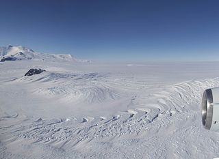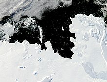
Thurston Island is a largely ice-covered, glacially dissected island, 135 nautical miles long and 55 nautical miles wide, lying between Amundsen Sea and Bellingshausen Sea a short way off the northwest end of Ellsworth Land, Antarctica. The island is separated from the mainland by Peacock Sound, which is occupied by the west portion of Abbot Ice Shelf.

The Byrd Glacier is a major glacier in Antarctica, about 136 km (85 mi) long and 24 km (15 mi) wide. It drains an extensive area of the Antarctic plateau, and flows eastward to discharge into the Ross Ice Shelf.
The Hauberg Mountains are a group of mountains of about 35 nautical miles extent, located 12 nautical miles north of Cape Zumberge and 30 nautical miles south of the Sweeney Mountains in eastern Ellsworth Land, Antarctica.
The Scaife Mountains is a group of mountains rising west of Prehn Peninsula and between the Ketchum Glacier and Ueda Glacier, at the base of the Antarctic Peninsula.

Mount Murphy is a snow-covered mountain with steep, rocky slopes rising to 2,505 metres (8,219 ft) in Marie Byrd Land, Antarctica. It is directly south of Bear Peninsula and is bounded by Smith Glacier, Pope Glacier, and Haynes Glacier. Volcanic activity began in the Miocene with the eruption of basaltic and trachytic lava. Volcanism on the slopes of the volcano resumed much later during the Pleistocene, with a parasitic cone having been K–Ar dated to 0.9 million years old.
Kohler Range is a mountain range in Marie Byrd Land, Antarctica. The range is about 40 nautical miles long and stands between the base of Martin Peninsula and Smith Glacier. The range consists of two ice-covered plateaus punctuated by several rock peaks and bluffs. The plateaus are oriented East-West and are separated by the Kohler Glacier, a distributary which flows north from Smith Glacier.

Bear Peninsula is a peninsula about 50 nautical miles long and 25 nautical miles wide which is ice-covered except for several isolated rock bluffs and outcrops along its margins, lying 3 nautical miles east of Martin Peninsula on Walgreen Coast, Marie Byrd Land, Antarctica.

The Getz Ice Shelf is an ice shelf over 300 nautical miles long and from 20 to 60 nautical miles wide, bordering the Hobbs Coast and Bakutis Coast of Marie Byrd Land, Antarctica, between the McDonald Heights and Martin Peninsula. Several large islands are partially or wholly embedded in the ice shelf.
Eights Coast is a portion of the coast of West Antarctica, between Cape Waite and Pfrogner Point. To the west is the Walgreen Coast, and to the east is the Bryan Coast. It is part of Ellsworth Land and stretches between 103°24'W and 89°35'W. This coast is bordered by Thurston Island, Abbot Ice Shelf and some islands within the ice shelf, and for most of its length touches the Bellingshausen Sea. Most of Eights Coast is not claimed by any nation. In the east, Eights Coast borders the sector claimed by Chile as part of its southernmost province. Peter I Island, 450 kilometers north of the coast, is claimed by Norway as a dependency.
King Peninsula is an ice-covered peninsula, 100 nautical miles long and 20 nautical miles wide, lying south of Thurston Island and forming the south side of Peacock Sound, Antarctica. It projects from the continental ice sheet and trends west between the Abbot Ice Shelf and Cosgrove Ice Shelf to terminate at the Amundsen Sea.

The Scott Glacier is a major glacier, 120 nautical miles long, that drains the East Antarctic Ice Sheet through the Queen Maud Mountains to the Ross Ice Shelf. The Scott Glacier is one of a series of major glaciers flowing across the Transantarctic Mountains, with the Amundsen Glacier to the west and the Leverett and Reedy glaciers to the east.
Nickerson Ice Shelf, is an ice shelf about 35 nautical miles wide, lying north of Siemiatkowski Glacier and the western part of Ruppert Coast, Marie Byrd Land, Antarctica.
The Crosson Ice Shelf is an ice shelf, about 35 nautical miles wide, located north and northeast of Mount Murphy along the Walgreen Coast of Marie Byrd Land, Antarctica. The ice shelf is nurtured by Smith Glacier, Pope Glacier, Vane Glacier, and Haynes Glacier.

Pope Glacier is a glacier about 20 nautical miles (37 km) long, flowing north along the west side of Mount Murphy to Crosson Ice Shelf on Walgreen Coast, in Marie Byrd Land. Mapped by United States Geological Survey (USGS) from surveys and U.S. Navy air photos, 1959–66. Named by Advisory Committee on Antarctic Names (US-ACAN) after Maj. Donald R. Pope, (CE) USA, civil engineer on the staff of the Commander, Naval Support Force, Antarctica, 1965–67. It is a tributary of Smith Glacier.
Perry Range is a narrow range of mountains, 6 nautical miles long, separating the lower ends of Venzke Glacier and Berry Glacier where they enter Getz Ice Shelf, on the coast of Marie Byrd Land, Antarctica.

The Dufek Coast is that portion of the coast along the southwest margin of the Ross Ice Shelf between Airdrop Peak on the east side of the Beardmore Glacier and Morris Peak on the east side of Liv Glacier. It was named by the New Zealand Antarctic Place-Names Committee in 1961 after Rear Admiral George J. Dufek, United States Navy, who served under Rear Admiral Richard E. Byrd with the United States Antarctic Service, 1939–41, and as commander of the Eastern Task Force of U.S. Navy Operation Highjump, 1946–47. He was Commander of U.S. Naval Support Force Antarctica, 1954–59, a period in which the following American science stations were established: McMurdo Station, Little America V, Byrd Station, South Pole Station, Wilkes Station, Hallett Station and Ellsworth Station. United States Navy ships, aircraft, and personnel under his command provided broad logistical support to research and survey operations, including aerial photographic missions to virtually all sectors of Antarctica. On October 31, 1956, Dufek in the ski-equipped R4D Skytrain aircraft Que Sera Sera, flew from McMurdo Sound via Beardmore Glacier to make the first airplane landing at the South Pole.
The McDonald Heights are broad, mainly snow-covered heights about 35 nautical miles (65 km) long and rising over 1,000 metres (3,300 ft) between Cape Burks and Morris Head on the coast of Marie Byrd Land, Antarctica. The heights are bounded southward by Hull Glacier, Kirkpatrick Glacier and Johnson Glacier.
Hughes Ice Piedmont is the ice piedmont between Cordini Glacier and Smith Inlet on the east coast of Palmer Land, Antarctica.

The Hull Glacier is a glacier, about 35 nautical miles long, flowing northwest between Mount Giles and Mount Gray into Hull Bay, in Marie Byrd Land, Antarctica.

Sarnoff Mountains is a range of mountains, 251 nautical miles long and 4 to 8 nautical miles wide separating the west-flowing Boyd Glacier and Arthur Glacier in the Ford Ranges of Marie Byrd Land, Antarctica.


