The Arctic Archipelago, also known as the Canadian Arctic Archipelago, is a group of islands north of the Canadian mainland.

The Filchner-Ronne Ice Shelf, also known as Ronne-Filchner Ice Shelf, is an Antarctic ice shelf bordering the Weddell Sea.

Baffin Bay, located between Baffin Island and the southwest coast of Greenland, is a marginal sea of the North Atlantic Ocean. It is connected to the Atlantic via Davis Strait and the Labrador Sea. The narrower Nares Strait connects Baffin Bay with the Arctic Ocean. The bay is not navigable most of the year because of the ice cover and high density of floating ice and icebergs in the open areas. However, a polynya of about 80,000 km2 (31,000 sq mi), known as the North Water, opens in summer on the north near Smith Sound. Most of the aquatic life of the bay is concentrated near that region.

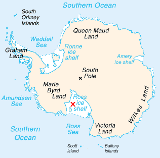
Marie Byrd Land is the portion of West Antarctica lying east of the Ross Ice Shelf and the Ross Sea and south of the Pacific Ocean, extending eastward approximately to a line between the head of the Ross Ice Shelf and Eights Coast. It stretches between 158°W and 103°24'W. The inclusion of the area between the Rockefeller Plateau and Eights Coast is based upon the leading role of the American Rear Admiral Richard E. Byrd in the exploration of this area. The name was originally applied by Admiral Byrd in 1929, in honor of his wife, to the northwestern part of the area, the part that was explored in that year.

The Bay of Whales was a natural ice harbor, or iceport, indenting the front of Ross Ice Shelf just north of Roosevelt Island, Antarctica. It is the southernmost point of open ocean not only of the Ross Sea, but worldwide. The Ross Sea extends much further south—as far as the Gould Coast, some 200 miles (320 km) from the South Pole—but most of that area is covered by the Ross Ice Shelf rather than open sea.

Ellsworth Land is that portion of the Antarctic continent bounded on the west by Marie Byrd Land, on the north by Bellingshausen Sea, on the northeast by the base of Antarctic Peninsula, and on the east by the western margin of Ronne Ice Shelf. It extends between 103°24'W and 79°45'W. The area west of 90°W is unclaimed, the area between 84°W and 90°W is claimed by Chile only, and the remainder by Chile and the United Kingdom as a part of the British Antarctic Territory. Eights Coast stretches between 103°24'W and 89°35'W, and Bryan Coast between 89°35'W and 79°45'W.

The Brunt Ice Shelf borders the Antarctic coast of Coats Land between Dawson-Lambton Glacier and Stancomb-Wills Glacier Tongue. It was named by the UK Antarctic Place-names Committee after David Brunt, British meteorologist, Physical Secretary of the Royal Society, 1948–57, who was responsible for the initiation of the Royal Society Expedition to this ice shelf in 1955.

King Edward VII Land or King Edward VII Peninsula is a large, ice-covered peninsula which forms the northwestern extremity of Marie Byrd Land in Antarctica. The peninsula projects into the Ross Sea between Sulzberger Bay and the northeast corner of the Ross Ice Shelf, and forms part of the Ross Dependency. Edward VII Peninsula is defined by the Ross Ice Shelf on the southwest, Okuma Bay on the west, and to the east by Sulzberger Bay and the Saunders Coast, all essentially on the Ross Sea / Southern Ocean in Antarctica. The northwest extremity of the peninsula is Cape Colbeck. Edward VII Peninsula is located at 77°40′S155°00′W.

Mertz Glacier is a heavily crevassed glacier in George V Coast of East Antarctica. It is the source of a glacial prominence that historically has extended northward into the Southern Ocean, the Mertz Glacial Tongue. It is named in honor of the Swiss explorer Xavier Mertz.
Saunders Coast is that portion of the coast of Marie Byrd Land between Cape Colbeck and Brennan Point, or between Shirase Coast in the west and Ruppert Coast in the east. It stretches from 158°01'W to 146°31'W. The portion west of 150°W is part of Ross Dependency, while the remaining area is unclaimed by any nation. This coast was explored from the air on December 5, 1929, by the Byrd Antarctic Expedition (1928–30) and was first mapped from aerial photographs obtained on that flight by Capt. Harold E. Saunders, USN, for whom the coast is named. The United States Geological Survey (USGS) completely mapped the coast from ground surveys and U.S. Navy air photos, 1959-65.
Sulzberger Bay is a bay between Fisher Island and Vollmer Island, along the coast of King Edward VII Land. Discovered by the Byrd Antarctic Expedition on December 5, 1929, and named by Byrd for Arthur H. Sulzberger, publisher of The New York Times, a supporter of the Byrd expeditions in 1928–1930 and 1933–1935.
Prestrud Inlet is a re-entrant in the south side of the Edward VII Peninsula, at the northeast corner of the Ross Ice Shelf. It was named by the U.S. Antarctic Service expedition (1939–41) in honor of Lt. Kristian Prestrud, leader of Amundsen's Eastern Sledge Party in 1911, who was first to traverse this region.
Siple Coast is the middle portion of the relatively ill-defined coast along the east side of the Ross Ice Shelf, between the north end of Gould Coast and the south end of Shirase Coast. The area was originally called Kirton Coast, but was renamed by NZ-APC in 1961 after Paul A. Siple, a noted American scientist-explorer who accompanied R. Admiral Richard E. Byrd on all of his Antarctic expeditions.

The Japanese Antarctic Expedition of 1910–12 was the first exploration of Antarctic territory by an expedition from Japan. Led by Army Lieutenant Nobu Shirase, its ship Kainan Maru left Tokyo in December 1910, reached the ice on 26 February 1911 and sailed on into the Ross Sea. As it was very late in the Antarctic season, the ship was not able to get beyond Coulman Island, and returned to Sydney, Australia to winter there.
The Echelmeyer Ice Stream, formerly known as Ice Stream F, is a glaciological feature of the West Antarctic Ice Sheet. It is an ice stream flowing west to the Shirase Coast to the north of the MacAyeal Ice Stream, and is one of several major ice streams draining from Marie Byrd Land into the Ross Ice Shelf. The ice streams were investigated and mapped by U.S. Antarctic Research Program personnel in a number of field seasons from 1983–84 and originally named Ice Stream A, B, C, etc., according to their position from south to north.
MacAyeal Ice Stream, formerly Ice Stream E, is an ice stream in Antarctica flowing west to the juncture of Shirase Coast and Siple Coast between Bindschadler Ice Stream and Echelmeyer Ice Stream. It is one of several major ice streams draining from Marie Byrd Land into the Ross Ice Shelf. The ice streams were investigated and mapped by U.S. Antarctic Research Program personnel in a number of field seasons from 1983–84 onwards and named Ice Stream A, B, C, etc., according to their position from south to north. The name was changed from Ice Scream E by the Advisory Committee on Antarctic Names in 2002 to honor Douglas R. MacAyeal of the Department of Geophysical Sciences, University of Chicago, a U.S. Antarctic Program investigator in the Ross Sea area including study of the Ross Ice Shelf, the West Antarctic Ice Sheet and the Marie Byrd Land ice streams, 1989–2002. Shabtaie Ice Ridge sits between the MacAyeal and Bundschadler ice streams.

The Swinburne Ice Shelf, is an ice shelf just north of Edward VII Peninsula and the Alexandra Mountains in the southern part of Sulzberger Bay, Antarctica. The ice shelf is 20 miles long and 5 miles wide and extends from Fisher Island to White Islands. It was photographed from aircraft and mapped by the Byrd Antarctic Expedition (ByrdAE), 1928-30. Named by Advisory Committee on Antarctic Names (US-ACAN) for Captain H.W Swinburne, Jr., Deputy Commander and Chief of Staff, U.S. Naval Support Force, Antarctica, during Operation Deep Freeze 1970 and 1971.
Kainan Bay is an iceport which indents the front of the Ross Ice Shelf about 37 nautical miles (70 km) northeast of the northwestern end of Roosevelt Island, Antarctica. It was discovered in January 1902 by the British National Antarctic Expedition under Robert Falcon Scott. It was named by the Japanese Antarctic Expedition under Lieutenant Shirase Nobu which, in January 1912, effected a landing on the ice shelf here from the ship Kainan Maru. Little America V, the main base of U.S. Navy Operation Deep Freeze, 1955–56, was established at this site in late December 1955.
The Richter Glacier is a low gradient coastal glacier located 18 km (11 mi) west of the Scott Nunataks on the northern side of Edward VII Peninsula. The feature saddles with the Butler Glacier and flows north-west to the sea where it forms a small tongue. The glacier and tongue are depicted on the map of the Byrd Antarctic Expedition, 1928-30. The map indicates that the landing party from the Kainan Maru (Shirase) traversed up this glacier to the summit of the Scott Nunataks in January 1912. The glacier was mapped in detail by the United States Geological Survey (USGS) from ground surveys and US Navy aerial photographs, 1959-65. It was named by the Advisory Committee on Antarctic Names (US-ACAN) for Gregory S. Richter, meteorologist-in-charge and scientific leader of the Byrd Station winter party in 1968.

Yamato Yukihara (大和雪原) was an Antarctic territory claimed by Japanese Army Lieutenant Shirase Nobu for Japan in 1912, spanning the entirety of the Ross Ice Shelf in what is now considered part of the New Zealand claim to Antarctic territory. This claim was reportedly not taken seriously by even the government of Japan, and quickly faded into historical and political oblivion after Shirase's return.