
The Antarctic Treaty and related agreements, collectively known as the Antarctic Treaty System (ATS), regulate international relations with respect to Antarctica, Earth's only continent without a native human population. It was the first arms control agreement established during the Cold War, setting aside the continent as a scientific preserve, establishing freedom of scientific investigation, and banning military activity; for the purposes of the treaty system, Antarctica is defined as all the land and ice shelves south of 60°S latitude. Since September 2004, the Antarctic Treaty Secretariat, which implements the treaty system, is headquartered in Buenos Aires, Argentina.

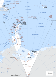
The South Shetland Islands are a group of Antarctic islands with a total area of 3,687 km2 (1,424 sq mi). They lie about 120 km (75 mi) north of the Antarctic Peninsula, and between 430 km (270 mi) to 900 km (560 mi) southwest from the nearest point of the South Orkney Islands. By the Antarctic Treaty of 1959, the islands' sovereignty is neither recognized nor disputed by the signatories and they are free for use by any signatory for non-military purposes.

King George Island is the largest of the South Shetland Islands, lying 120 km off the coast of Antarctica in the Southern Ocean. The island was named after King George III.

Base General Bernardo O'Higgins Riquelme, also Base Libertador General Bernardo O'Higgins Riquelme, or shortly Bernardo O'Higgins, named after Bernardo O'Higgins, is a permanently staffed Chilean research station in Antarctica and the capital of Antártica Commune. It lies at 63°19′15″S57°53′55″W, at an elevation of 13 m, about 30 km south-west of Prime Head, the northernmost point of the Antarctic Peninsula, at Cape Legoupil.
Argentine Antarctica is an area of Antarctica claimed by Argentina as part of its national territory. It consists of the Antarctic Peninsula and a triangular section extending to the South Pole, delimited by the 25° West and 74° West meridians and the 60° South parallel. This region overlaps the British and Chilean claims in Antarctica. Argentina's Antarctic claim is based on its continued presence in the region since 1904, and the area's proximity to the South American continent. Argentina's claim to this area is subject to the Antarctic Treaty. Administratively, Argentine Antarctica is a department of the province of Tierra del Fuego, Antarctica, and South Atlantic Islands. The provincial authorities are based in Ushuaia. Despite the claim to this Antarctic area, Argentinean authority extends no further than the nation's bases. The Argentine exploration of the continent started early in the 20th century. José María Sobral was the first Argentine to set foot on Antarctica, in 1902, where he spent two seasons with the Swedish Antarctic Expedition of Otto Nordenskiöld. Shortly afterward, in 1904, the Orcadas permanent base was already fully operational. Years later other bases would be created, some permanent and others seasonal. The first Argentine expedition to reach the South Pole was the 1965 Operación 90.

Stonington Island is a rocky island lying 1.8 km (1.1 mi) northeast of Neny Island in the eastern part of Marguerite Bay off the west coast of Graham Land, Antarctica. It is 0.75 km (0.47 mi) long from north-west to south-east and 0.37 km (0.23 mi) wide, yielding an area of 20 ha. It was formerly connected by a drifted snow slope to Northeast Glacier on the mainland. Highest elevation is Anemometer Hill which rises to 25 m (82 ft).

The Chilean Antarctic Territory or Chilean Antarctica is the territory in Antarctica claimed by Chile. The Chilean Antarctic Territory ranges from 53° West to 90° West and from the South Pole to the 60° South parallel, partially overlapping the Argentine and British Antarctic claims. It is administered by the Cabo de Hornos municipality in the South American mainland.

The Great Wall Station is the first Chinese research station in Antarctica and opened on 20 February 1985. It lies on the Fildes Peninsula on King George Island, and is about 2.5 kilometres (1.6 mi) from the Chilean Frei Montalva Station, and 960 kilometres (600 mi) from Cape Horn. The station is sited on ice-free rock, about 10 metres (33 ft) above sea level.
Pendulum Cove is a cove at the north-east side of Port Foster, Deception Island, in the South Shetland Islands of Antarctica. The name of the cove derives from the pendulum and magnetic observations made there by the British expedition under Henry Foster in 1829.
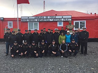
Captain Arturo Prat Base is a Chilean Antarctic research station located at Iquique Cove, Greenwich Island in the South Shetland Islands, Antarctica.

Yankee Harbour is a small inner harbour entered from Shopski Cove between Glacier Bluff and Spit Point, indenting the south-west side of Greenwich Island in the South Shetland Islands, Antarctica. It is 2.35 km (1.46 mi) long in west-south-west to east-north-east direction, and 1.6 km (0.99 mi) wide, and is bounded by Provadiya Hook to the south-west, Parvomay Neck to the north and east, and Kladara Beach to the south.
Foyn Island, also known as Svend Foyn Island, is the second largest island in the Possession Islands, East Antarctica, lying 6 kilometres (4 mi) south-west of Possession Island. An Adélie penguin rookery covers much of the island, which is often included in the itinerary of Antarctic cruises.
Detaille Island is a small island off the northern end of the Arrowsmith Peninsula in Graham Land, Antarctica. From 1956 to 1959 it was home to "Base W" of the British Antarctic Survey and closed after the end of the International Geophysical Year (IGY). It is now often visited by Antarctic cruise ships but is otherwise unoccupied.

Waterboat Point is the low westernmost termination of the peninsula between Paradise Harbor and Andvord Bay on the west coast of Graham Land. This feature has "island" characteristics, but it is only separated from the mainland at high water and is more usefully described as a "point". Chile's González Videla Antarctic Base is located at Waterboat Point.
Potter Cove is a cove indenting the south-west side of King George Island to the east of Barton Peninsula, in the South Shetland Islands of Antarctica. An extinct volcano named Three Brothers Hill is located on its east side. Potter Cove was known to sealers as early as 1821, and the name is now well established in international usage.
Potter Peninsula is a low ice-free peninsula between Potter Cove and Stranger Point in south-west King George Island, in the South Shetland Islands of Antarctica. It is protected as ASPA 132, largely because of the richness and diversity of its flora and fauna.

Half Moon Beach is a small crescent-shaped beach lying 1 nautical mile (2 km) south-east of Scarborough Castle on the north coast of Livingston Island, in the South Shetland Islands of Antarctica. The beach lieas at the western extremity of Porlier Bay in the north of Ioannes Paulus II Peninsula.
Maxwell Bay, also called Fildes Bay and Guardia Nacional Bay is a bay 19 km (12 mi) long, lying between King George Island and Nelson Island, in the South Shetland Islands of Antarctica. The main entrance to the bay is at the south-east side and is wide open; Fildes Strait on the north-west side is encumbered by rocks and is only navigable by boats. The name "Maxwells Straits" was given to this bay and to Fildes Strait by British sealing captain James Weddell in 1822–24, for Lieutenant Francis Maxwell who had served with Weddell in 1813–14. The name was altered and limited to the feature here described by the UK Antarctic Place-Names Committee in 1960.

Whalers Bay is a small bay entered between Fildes Point and Penfold Point at the east side of Port Foster, Deception Island, in the South Shetland Islands of Antarctica. The bay was so named by the French Antarctic Expedition, 1908–10, under Charcot, because of its use at that time by whalers.

A.B. Dobrowolski Polar Station is a occasionally active Polish polar research station in Antarctica. It is located at the edge of the Algae Lake, Bunger Hills region in the Wilkes Land and was originally constructed by the Soviet Union. It is one of the two Polish stations in Antarctica, the other being the Henryk Arctowski Polish Antarctic Station.
