Deception Island is an island in the South Shetland Islands close to the Antarctic Peninsula with a large and safe natural harbor. This island is the caldera of an active volcano, which seriously damaged local scientific stations in 1967 and 1969. The island previously held a whaling station; it is now the most popular tourist destination with over 15000 visitors per year with holding two scientific stations from Argentina and Spain operational during summer season. While various countries have asserted sovereignty, it is still administered under the Antarctic Treaty System.

Alexander Island, which is also known as Alexander I Island, Alexander I Land, Alexander Land, Alexander I Archipelago, and Zemlja Alexandra I, is the largest island of Antarctica. It lies in the Bellingshausen Sea west of Palmer Land, Antarctic Peninsula from which it is separated by Marguerite Bay and George VI Sound. George VI Ice Shelf entirely fills George VI Sound and connects Alexander Island to Palmer Land. The island partly surrounds Wilkins Sound, which lies to its west. Alexander Island is about 390 kilometres (240 mi) long in a north–south direction, 80 kilometres (50 mi) wide in the north, and 240 kilometres (150 mi) wide in the south. Alexander Island is the second largest uninhabited island in the world, after Devon Island.

Operation Tabarin was a secret British Antarctic expedition, during World War II. It was launched in 1943 under the pretense of patrolling the Antarctic for German commerce raiders and U-boats that threatened Allied shipping.
Argentine Antarctica is a sector of Antarctica claimed by Argentina as part of its national territory. It consists of the Antarctic Peninsula and a triangular section extending to the South Pole, delimited by the 25° West and 74° West meridians and the 60° South parallel. This region overlaps the British and Chilean claims in Antarctica. Argentina's Antarctic claim is based on its continued presence in the region since 1904, and the area's proximity to the South American continent. Argentina's claim to this area is subject to the Antarctic Treaty. Administratively, Argentine Antarctica is a department of the province of Tierra del Fuego, Antarctica, and South Atlantic Islands. The provincial authorities are based in Ushuaia. Despite the claim to this Antarctic area, Argentine authority extends no further than the nation's bases. The South Orkney Islands are part of Islas del Atlántico Sur Department, which includes the British overseas territories of the Falkland Islands and the South Georgia and South Sandwich Islands.

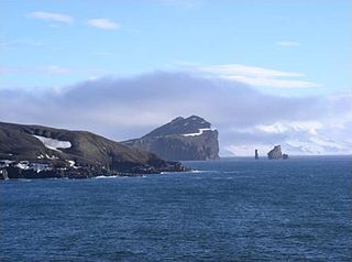
Neptune's Bellows is a channel on the southeast side of Deception Island forming the entrance to Port Foster, in the South Shetland Islands. The name, after the Roman sea god Neptune, was appended by American sealers prior to 1822 because of the strong gusts experienced in this narrow channel.

Pendulum Cove is a cove at the north-east side of Port Foster, Deception Island, in the South Shetland Islands of Antarctica. The name of the cove derives from the pendulum and magnetic observations made there by the British expedition under Henry Foster in 1829.

Sewing-Machine Needles, also known as Rocas Ministro Ezcurra is a group of three prominent rock needles, the highest 45 m above water, lying close southeast of Rancho Point, Deception Island, in the South Shetland Islands. The name Sewing-Machine Rock was given by whalers for what was originally a conspicuous natural arch. Needles is now considered the more suitable descriptive term; an earthquake tremor in 1924 caused the arch to collapse. The name Rocas Ministro Ezcurra was given by Dr Douglas Mawson, leader of the Australasian Antarctic Expedition of 1912-14.

Sikorsky Glacier is a glacier on the west coast of Graham Land, Antarctica draining northwestwards into Hughes Bay north of Charles Point.
Telefon Bay is a small bay on the north-west coast of Port Foster, Deception Island, in the South Shetland Islands of Antarctica. It is surmounted by Telefon Ridge. The name appears on the chart of the French Antarctic Expedition under Charcot, 1908–10.
Gilbert Strait is a strait between Trinity Island and Tower Island in the Palmer Archipelago. The strait was named by a British expedition 1828–31, under Foster, for Davies Gilbert, President of the Royal Society from 1827–30, and of the committee which formulated the objectives of the expedition. The strait was mapped by the Swedish Antarctic Expedition (SAE) of 1901–04, under Otto Nordenskjöld.
Port Foster is one of the safest harbours in Antarctica, located in Deception Island in the South Shetland Islands.
Bruce Plateau is an ice-covered plateau, at least 90 nautical miles (170 km) long and about 1,830 metres (6,000 ft) high, extending northeast from the heads of Gould Glacier and Erskine Glacier to the vicinity of Flandres Bay, in Graham Land. It borders Avery Plateau on the south and Forbidden Plateau on the north. The first sighting of this plateau has not been ascertained, but it was presumably seen in January 1909 by members of the French Antarctic Expedition under Jean-Baptiste Charcot from their position in Pendleton Strait. The plateau was mapped from aerial photographs and from Falkland Islands Dependencies Survey surveys, 1946–62, and named by the UK Antarctic Place-Names Committee after William S. Bruce, a Scottish polar explorer and leader of the Scottish National Antarctic Expedition, 1902–04.
Cape Cockburn is a cape marking the northeastern extremity of Pasteur Peninsula on Brabant Island, in the Palmer Archipelago. The name appears on a chart based upon a British expedition under Henry Foster, 1828–31, who perhaps gave the name for George Cockburn, British naval officer and Admiral of the Fleet in 1851. The cape was charted by the French Antarctic Expedition, 1903–05, under Jean-Baptiste Charcot. The cape was photographed from the air by Falkland Islands and Dependencies Aerial Survey Expedition in 1956–57.
Wensleydale Beacon is a hill, 110 m, situated just north of Fumarole Bay, on the west side of Port Foster, Deception Island, in the South Shetland Islands. The hill was charted by a British expedition 1828–31, under Foster. Named by Lieutenant Commander D.N. Penfold, Royal Navy, following his survey of the island in 1948–49, after Wensleydale in Yorkshire, England.

The Stokes Peaks is a group of peaks rising to about 800 m between McCallum Pass and Sighing Peak on the north side of Wright Peninsula, Adelaide Island, Antarctica. They were photographed from the air by the Falkland Islands and Dependencies Aerial Survey Expedition (FIDASE), 1956–57, and surveyed by the British Antarctic Survey (BAS), in 1961–62. They were named by the United Kingdom Antarctic Place-Names Committee (UK-APC) in 1977 for Jeffrey C.A. Stokes, Falkland Islands Dependencies Survey (FIDS) assistant surveyor, Admiralty Bay, 1959–60, and Adelaide Island, 1960–61.
Stonethrow Ridge is a snow-covered ridge rising west of Fumarole Bay on Deception Island, in the South Shetland Islands of Antarctica. Vapour Col lies to the south of the ridge.

Cape Garry is a cape forming the south-western extremity of Low Island in the South Shetland Islands of Antarctica. It was charted and named by a British expedition under Henry Foster, 1828–31, and was more accurately mapped by the Falkland Islands Dependencies Survey in 1959 from aerial photographs taken by the Falkland Islands and Dependencies Aerial Survey Expedition, 1955–57.
Herbert Plateau is a portion of the central plateau of Graham Land, Antarctica, lying between Blériot Glacier and Drygalski Glacier. It borders Foster Plateau on the south and Detroit Plateau on the north. The feature was photographed by the Falkland Islands and Dependencies Aerial Survey Expedition in 1956–57 and mapped from these photos by the Falkland Islands Dependencies Survey (FIDS). It was named by the UK Antarctic Place-Names Committee in 1960 for Walter W. Herbert, a FIDS assistant surveyor at the Hope Bay station in 1956 and 1957.
Vapour Col is a col lying south of Stonethrow Ridge on the west side of Deception Island in the South Shetland Islands of Antarctica. The name given by the United Kingdom Antarctic Place-Names Committee (UK-APC) in 1959 originates from the fumaroles in the col. This is the only locality on Deception Island where there is a complete cross section through the stratigraphy of volcanic succession. Having a similar name in the same island is the Fumarole Bay.
The Falkland Islands and Dependencies Aerial Survey Expedition (FIDASE) was an aerial survey of the Falkland Islands Dependencies and the Antarctic peninsula which took place in the 1955–56 and 1956–57 southern summers.

