
Nikopol Point is an ice-free point on the south coast of Byers Peninsula, Livingston Island in the South Shetland Islands, Antarctica projecting 650 m east-southeastwards into Bransfield Strait and linked by a spit to Vietor Rock to the south. The area was visited by early 19th century sealers who had dwellings at the foothills of nearby Sealer Hill.

Varna Peninsula is a roughly rectangular predominantly ice-covered peninsula forming the northeast extremity of Livingston Island in the South Shetland Islands, Antarctica. It is bounded by Hero Bay to the northwest, by Moon Bay to the southeast, and by McFarlane Strait to the northeast.

Hannah Point is a point on the south coast of Livingston Island in the South Shetland Islands, Antarctica. It forms the east side of the entrance to Walker Bay and the west side of the entrance to South Bay. Surmounted by Ustra Peak to the north, with Liverpool Beach extending between the peak and the tip of Hannah Point. Ice-free area ca. 122 hectares.
President Beaches is a series of beaches which extend for 6 nautical miles (11 km) along the broad western end of Byers Peninsula, Livingston Island in the South Shetland Islands, Antarctica between Start Point to the north and Devils Point to the south.
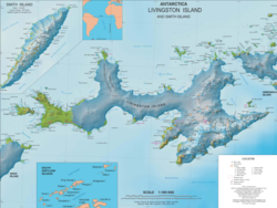
Byers Peninsula is a mainly ice-free peninsula forming the west end of Livingston Island in the South Shetland Islands of Antarctica. It occupies 60 km2 (23 sq mi), borders Ivanov Beach to the northeast and is separated from Rotch Dome on the east by the ridge of Urvich Wall. The peninsula features more than 60 meltwater streams and as many lakes, notably Midge Lake, Limnopolar Lake and Basalt Lake. Byers Peninsula has a regime of special environmental protection under the Antarctic Treaty System and requires a permit to enter.

Vund Point is the point forming the east extremity of Rugged Island off the west coast of Byers Peninsula of Livingston Island in the South Shetland Islands, Antarctica. The area was visited by early 19th century sealers.
Sevar Point is a point on the south coast of Byers Peninsula on Livingston Island in the South Shetland Islands, Antarctica situated 1.9 km east-southeast of Devils Point, 2.71 km west of Nikopol Point, and 2.97 km northeast of Long Rock in Morton Strait. It is surmounted by Wasp Hill on the north-northeast, Sealer Hill on the east-northeast, and forms the east side of the entrance to Raskuporis Cove.
Dospey Heights are the ice-free heights on Ray Promontory in the northwestern part of Byers Peninsula on Livingston Island in the South Shetland Islands, Antarctica. Extending 6 km southeastwards from Essex Point and Start Point, and 2.6 km wide. Rising to 265 m at Start Hill.
Voyteh Point is the point forming the east side of the entrance to Richards Cove on the north coast of Ray Promontory in the northwestern part of Byers Peninsula on Livingston Island in the South Shetland Islands, Antarctica. It is surmounted by Sàbat Hill. The area was visited by early 19th century sealers.
Window Island is a small ice-free island off the north coast of Ray Promontory in the northwest of Byers Peninsula, Livingston Island in the South Shetland Islands, Antarctica. The island has a surface area of 23 hectares and rises to 72 m (236 ft). It was known to the early 19th century sealers operating on Byers Peninsula.
Lair Point is a point projecting 570 m into Barclay Bay from Robbery Beaches on Byers Peninsula, Livingston Island in the South Shetland Islands, Antarctica and forming the east side of the entrance to Kukuzel Cove. Dominated by Lair Hill.
Laager Point is a conspicuous headland extending out from President Beaches on Byers Peninsula, Livingston Island in the South Shetland Islands, Antarctica facing Astor Island. It forms the southeast entrance point for New Plymouth harbour and the northeast entrance point for Osogovo Bay. Naiad Lake is situated on the southwest side of the point and Pistiros Lake is centred 900 m east of it. The area was visited by 19th century sealers.
Negro Hill is a conspicuous rocky hill, double-peaked with a small tarn in between, rising to 100 m at South Beaches on Byers Peninsula, Livingston Island in the South Shetland Islands, Antarctica. It surmounts Fontus Lake on the south. The area was visited by 19th-century sealers.
Wasp Hill is a hill rising to 72 meters in the southwest part of Byers Peninsula, Livingston Island in the South Shetland Islands, Antarctica. Surmounting Sevar Point to the south-southwest. The area was visited by 19th century sealers.

Glaciar Rocoso Cove is a small open cove, part of False Bay, Livingston Island in the South Shetland Islands, Antarctica. It is 920 m wide and indenting for 180 m the southeast coast of Hurd Peninsula east-northeast of Binn Peak and south-southwest of Nusha Hill. The area was visited by early 19th century sealers.
Camp Livingston is an Argentine seasonal base camp on Byers Peninsula, Livingston Island in the South Shetland Islands, Antarctica. The area was visited by early 19th century sealers.
Station P was a British base camp at the head of Mateev Cove on the east side of Hannah Point, Livingston Island in the South Shetland Islands, Antarctica that supported survey, geology and biology field work from 29 December 1957 until 15 March 1958. The camp was occupied by a six-member team led by Hugh Simpson. The surveyed areas included parts of Byers Peninsula, Elephant Point, Ioannes Paulus II Peninsula and Hurd Peninsula.
Richards Cove is the 450 m wide cove indenting for 550 m the north coast of Ray Promontory, Byers Peninsula, Livingston Island in the South Shetland Islands, Antarctica, entered east of Aglen Point and west of Voyteh Point. The area was visited by early 19th century sealers.
Ivanov Beach is a mostly ice-free beach on the Drake Passage stretching 5 km (3.1 mi) in southwest–northeast direction on the southeast coast of Barclay Bay in western Livingston Island, South Shetland Islands in Antarctica. It extends to Nedelya Point and Byers Peninsula on the southwest, Rowe Point and Etar Snowfield on the northeast, and the slopes of Rotch Dome on the southeast. Its ice-free area is ca. 144 hectares.


