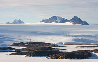
The geography of Antarctica is dominated by its south polar location and, thus, by ice. The Antarctic continent, located in the Earth's southern hemisphere, is centered asymmetrically around the South Pole and largely south of the Antarctic Circle. It is washed by the Southern Ocean or, depending on definition, the southern Pacific, Atlantic, and Indian Oceans. It has an area of more than 14.2 million km2. Antarctica is the largest ice desert in the world.

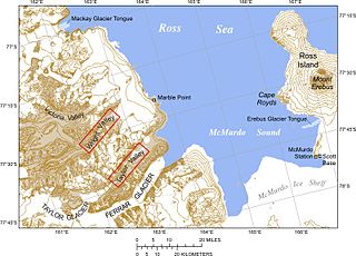
Ross Island is an island in Antarctica lying on the east side of McMurdo Sound and extending 43 nautical miles from Cape Bird in the north to Cape Armitage in the south, and a similar distance from Cape Royds in the west to Cape Crozier in the east. The island is entirely volcanic. Mount Erebus, 3,795 metres (12,451 ft), near the center, is an active volcano. Mount Terror, 3,230 metres (10,600 ft) about 20 nautical miles eastward, is an extinct volcano. Mount Bird rises to 1,765 metres (5,791 ft) just south of Cape Bird.

Mount Erebus is the southernmost active volcano on Earth, located on Ross Island in the Ross Dependency in Antarctica. With a summit elevation of 3,792 metres (12,441 ft), it is the second most prominent mountain in Antarctica and the second-highest volcano in Antarctica. It is the highest point on Ross Island, which is also home to three inactive volcanoes: Mount Terror, Mount Bird, and Mount Terra Nova. It makes Ross Island the sixth-highest island on Earth.

Mawson Station, commonly called Mawson, is one of three permanent bases and research outposts in Antarctica managed by the Australian Antarctic Division (AAD). Mawson lies in Holme Bay in Mac. Robertson Land, East Antarctica in the Australian Antarctic Territory, a territory claimed by Australia. Established in 1954, Mawson is Australia's oldest Antarctic station and the oldest continuously inhabited Antarctic station south of the Antarctic Circle. It houses approximately 20 personnel over winter and up to 53 in summer.

McMurdo Station is an American Antarctic research station on the southern tip of Ross Island. It is operated by the United States through the United States Antarctic Program (USAP), a branch of the National Science Foundation. The station is the largest community in Antarctica, capable of supporting up to 1,500 residents, though the population fluctuates seasonally; during the antarctic night, there are as few as a few hundred people. It serves as one of three year-round United States Antarctic science facilities. Personnel and cargo going to or coming from Amundsen–Scott South Pole Station usually first pass through McMurdo, either by flight or by the McMurdo to South Pole Traverse; it is a hub for activities and science projects in Antarctica. McMurdo, Amundsen-Scott, and Palmer are the three United States stations on the continent, though by the Antarctic Treaty System the bases are not a legal claim ; they are dedicated to scientific research. New Zealand's Scott Base is nearby on Hut Point Peninsula, as is Arrival Heights Laboratory. Across the channel is a helicopter refueling station at Marble Point, but the main airfields in the 2020s are Phoenix Airfield and Williams Field. Winter Quarters Bay as the a sea port, though access can be limited by weather conditions when the sea ice forms. Weather can make it too hard to land aircraft, and an icebreaker may be needed to reach the port facility. However, the sea ice also makes it possible to make ice traverses and travel directly across the bay, and historically an Ice Runway was crafted. The base is powered by a mixture of generators and wind power, though it had a nuclear reactor in the 1960s.

Mount Terror is an extinct volcano about 3,230 metres (10,600 ft) high on Ross Island, Antarctica, about 20 nautical miles eastward of Mount Erebus. Mount Terror was named in 1841 by polar explorer Sir James Clark Ross for his second ship, HMS Terror.

The McMurdo Sound is a sound in Antarctica, known as the southernmost passable body of water in the world, located approximately 1,300 kilometres (810 mi) from the South Pole.

The United States Antarctic Program is an organization of the United States government which has a presence in the Antarctica continent. Founded in 1959, the USAP manages all U.S. scientific research and related logistics in Antarctica as well as aboard ships in the Southern Ocean.

Mount Melbourne is a 2,733-metre-high (8,967 ft) ice-covered stratovolcano in Victoria Land, Antarctica, between Wood Bay and Terra Nova Bay. It is an elongated mountain with a summit caldera filled with ice with numerous parasitic vents; a volcanic field surrounds the edifice. Mount Melbourne has a volume of about 180 cubic kilometres (43 cu mi) and consists of tephra deposits and lava flows; tephra deposits are also found encased within ice and have been used to date the last eruption of Mount Melbourne to 1892 ± 30 years. The volcano is fumarolically active.

Mount Morning is a shield volcano at the foot of the Transantarctic Mountains in Victoria Land, Antarctica. It lies 100 kilometres (62 mi) from Ross Island. Mount Morning rises to an elevation of 2,723 metres (8,934 ft) and is almost entirely mantled with snow and ice. A 4.1 by 4.9 kilometres wide summit caldera lies at the top of the volcano and several ice-free ridges such as Hurricane Ridge and Riviera Ridge emanate from the summit. A number of parasitic vents mainly in the form of cinder cones dot the mountain.

Mount Takahe is a 3,460-metre-high (11,350 ft) snow-covered shield volcano in Marie Byrd Land, Antarctica, 200 kilometres (120 mi) from the Amundsen Sea. It is a c. 30-kilometre-wide (19 mi) mountain with parasitic vents and a caldera up to 8 kilometres (5 mi) wide. Most of the volcano is formed by trachytic lava flows, but hyaloclastite is also found. Snow, ice, and glaciers cover most of Mount Takahe. With a volume of 780 km3 (200 cu mi), it is a massive volcano; the parts of the edifice that are buried underneath the West Antarctic Ice Sheet are probably even larger. It is part of the West Antarctic Rift System along with 18 other known volcanoes.

A subglacial volcano, also known as a glaciovolcano, is a volcanic form produced by subglacial eruptions or eruptions beneath the surface of a glacier or ice sheet which is then melted into a lake by the rising lava. Today they are most common in Iceland and Antarctica; older formations of this type are found also in British Columbia and Yukon Territory, Canada.

Brabant Island is the second largest island of the Palmer Archipelago within the British Antarctic Territory, lying between Anvers Island and Liège Island. Brabant Island is 59 km (37 mi) long north-south, 30 km (19 mi) wide, and rises to 2,520 m (8,268 ft) in Mount Parry. The interior of the island is occupied by two mountain ranges, Solvay Mountains in its southern part and Stribog Mountains in its central and northern parts.

The Erebus Glacier Tongue is a mountain outlet glacier and the seaward extension of Erebus Glacier from Ross Island. It projects 11 kilometres (6.8 mi) into McMurdo Sound from the Ross Island coastline near Cape Evans, Antarctica. The glacier tongue varies in thickness from 50 metres (160 ft) at the snout to 300 metres (980 ft) at the point where it is grounded on the shoreline. Explorers from Robert F. Scott's Discovery Expedition (1901–1904) named and charted the glacier tongue.
UNAVCO was a non-profit university-governed consortium that facilitated geology research and education using geodesy.

Aster Glacier is an Antarctic glacier descending the east slope of Craddock Massif and flowing between Elfring Peak and Willis Ridge to Thomas Glacier in the Sentinel Range, Ellsworth Mountains in Antarctica. It was named by the Advisory Committee on Antarctic Names in 2006, after Richard Aster, Professor of Geophysics and Department Head of Geosciences at Colorado State University, whose research in Antarctica includes volcanological studies at the Mount Erebus volcano observatory on Ross Island, glaciological, oceanic, and tectonic seismic source studies, seismic tomography, ice shelf studies, and the coupling of solid Earth geophysics and Antarctic ice sheet evolution.

The Ross expedition was a voyage of scientific exploration of the Antarctic in 1839 to 1843, led by James Clark Ross, with two unusually strong warships, HMS Erebus and HMS Terror. It explored what is now called the Ross Sea and discovered the Ross Ice Shelf. On the expedition, Ross discovered the Transantarctic Mountains and the volcanoes Mount Erebus and Mount Terror, named after each ship. The young botanist Joseph Dalton Hooker made his name on the expedition.
Mount Rittmann is a volcano in Antarctica. Discovered in 1988–1989 by an Italian expedition, it was named after the volcanologist Alfred Rittmann (1893–1980). It features a 2 kilometres (1.2 mi) or 8 by 5 kilometres wide caldera which crops out from underneath the Aviator Glacier. The volcano was active during the Pliocene and into the Holocene, including large explosive eruptions; a major eruption occurred in 1254 CE and deposited tephra over much of Antarctica. Currently, the volcano is classified as dormant.

Mount Berlin is a glacier-covered volcano in Marie Byrd Land, Antarctica, 100 kilometres (62 mi) from the Amundsen Sea. It is a roughly 20-kilometre-wide (12 mi) mountain with parasitic vents that consists of two coalesced volcanoes: Berlin proper with the 2-kilometre-wide (1.2 mi) Berlin Crater and Merrem Peak with a 2.5-by-1-kilometre-wide crater, 3.5 kilometres (2.2 mi) away from Berlin. The summit of the volcano is 3,478 metres (11,411 ft) above sea level. It has a volume of 200 cubic kilometres (48 cu mi) and rises from the West Antarctic Ice Sheet. It is part of the Marie Byrd Land Volcanic Province. Trachyte is the dominant volcanic rock and occurs in the form of lava flows and pyroclastic rocks.
The EarthScope Primary Instrument Center is a research center at New Mexico Institute of Mining and Technology for geophysics research in Earth system science. The facility provides instrumentation and support services for seismology experiments around the world, as well as those for the National Science Foundation and the U.S. Department of Energy.


