
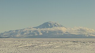
Mount Erebus is the southernmost active volcano on Earth, located on Ross Island in the Ross Dependency in Antarctica. With a summit elevation of 3,792 metres (12,441 ft), it is the second most prominent mountain in Antarctica and the second-highest volcano in Antarctica. It is the highest point on Ross Island, which is also home to three inactive volcanoes: Mount Terror, Mount Bird, and Mount Terra Nova. It makes Ross Island the sixth-highest island on Earth.

Victoria Land is a region in eastern Antarctica which fronts the western side of the Ross Sea and the Ross Ice Shelf, extending southward from about 70°30'S to 78°00'S, and westward from the Ross Sea to the edge of the Antarctic Plateau. It was discovered by Captain James Clark Ross in January 1841 and named after Queen Victoria. The rocky promontory of Minna Bluff is often regarded as the southernmost point of Victoria Land, and separates the Scott Coast to the north from the Hillary Coast of the Ross Dependency to the south.
Skelton Glacier is a large glacier flowing from the polar plateau into the Ross Ice Shelf at Skelton Inlet on the Hillary Coast, south of Victoria Land, Antarctica.
The Cook Mountains is a group of mountains bounded by the Mulock and Darwin glaciers in Antarctica. They are south of the Worcester Range and north of the Darwin Mountains and the Britannia Range.

The Royal Society Range is a majestic range of mountains in Victoria Land, Antarctica, rising to 4,025 metres (13,205 ft) along the west shore of McMurdo Sound between the Koettlitz, Skelton and Ferrar Glaciers. They are south of the Kukri Hills, southeast of the Quartermain Mountains, and northeast of the Worcester Range.
Mount Discovery is a conspicuous, isolated volcanic cone, 2,680 metres (8,790 ft) high, lying at the head of McMurdo Sound and east of Koettlitz Glacier, overlooking the northwest portion of the Ross Ice Shelf. It forms the center of a three-armed mass of which Brown Peninsula is one extension to the north; Minna Bluff is a second to the east; the third is Mount Morning to the west. Mount Discovery was discovered by the British National Antarctic Expedition (1901–04) and named for their expedition ship Discovery.

Koettlitz Glacier is a large Antarctic glacier lying west of Mount Morning and Mount Discovery in the Royal Society Range, flowing from the vicinity of Mount Cocks northeastward between Brown Peninsula and the mainland into the ice shelf of McMurdo Sound.

The Dailey Islands are a group of small volcanic islands lying off the coast of Victoria Land, 9 kilometres (5 nmi) northeast of Cape Chocolate, in the northern part of the ice shelf bordering McMurdo Sound. They were discovered by the British National Antarctic Expedition, 1901–04, under Robert Falcon Scott, and named for Fred E. Dailey, the expedition carpenter.
White Island is an island in the Ross Archipelago of Antarctica. It is 15 nautical miles long, protruding through the Ross Ice Shelf immediately east of Black Island. It was discovered by the British National Antarctic Expedition (1901–04) and so named by them because of the mantle of snow that covers it.
Lennox-King Glacier is a large valley glacier, about 40 nautical miles (70 km) long that flows east into the Ross Ice Shelf.

Black Island, is an island in the Ross Archipelago, 12 nautical miles long, projecting through the Ross Ice Shelf to a height of 1,040 metres (3,410 ft).meters. It was discovered by the British National Antarctic Expedition and named by them for its appearance. The island is largely ice free and principally composed of black volcanic rock. The island's northernmost point is named Cape Hodgson, commemorating Thomas Vere Hodgson, one of the oldest members of the Discovery Expedition.
Mount Bird is a 1,765 metres (5,791 ft) high shield volcano standing about 7 nautical miles south of Cape Bird, the northern extremity of Ross Island. It was mapped by the British National Antarctic Expedition, 1901–04, under Robert Falcon Scott, and apparently named by them after Cape Bird.
Ross Archipelago is a name for that group of islands which, together with the ice shelf between them, forms the eastern and southern boundaries of McMurdo Sound in Antarctica. The most northerly is Beaufort Island, then comes Ross Island, the Dellbridge Islands, and Black Island and White Island. Frank Debenham's classic report, The Physiography of the Ross Archipelago, 1923, described "Brown Island" as a part of the group.
Minna Bluff is a narrow, bold peninsula, 25 nautical miles long and 3 nautical miles wide, projecting southeast from Mount Discovery into the Ross Ice Shelf, Antarctica. It was discovered by the British National Antarctic Expedition (1901-04) which named it for Minna, the wife of Sir Clements Markham, the "father" of the expedition. It culminates in a south-pointing hook feature, and is the subject of research into Antarctic cryosphere history, funded by the National Science Foundation, Office of Polar Programs.
The Mulock Glacier is a large, heavily crevassed glacier which flows into the Ross Ice Shelf 40 kilometers south of the Skelton Glacier in the Ross Dependency, Antarctica.
The Worcester Range is a high coastal range, about 30 nautical miles long, in Antarctica. It stands between Skelton Glacier and Mulock Glacier on the western side of the Ross Ice Shelf. It is southwest of the Royal Society Range and north of the Conway Range of the Cook Mountains.

Brown Peninsula is a nearly ice-free peninsula, 10 nautical miles long and 4 nautical miles wide, which rises above the Ross Ice Shelf northward of Mount Discovery, to which it is connected by a low isthmus. It was discovered by the British National Antarctic Expedition, 1901–04 (BrNAE), which named it "Brown Island" because of its color and its island-like character. Since it is a peninsula, the name has been altered accordingly.
The Darley Hills are a range of high, ice-covered coastal hills in the Churchill Mountains, Antarctica.
Starshot Glacier is a glacier 50 nautical miles (90 km) long that flows through the Churchill Mountains to enter the Ross Ice Shelf in Antarctica.
Blue Glacier is a large glacier which flows into Bowers Piedmont Glacier about 10 nautical miles south of New Harbour, in Victoria Land, Antarctica. It was discovered by the British National Antarctic Expedition (BrNAE) under Robert Falcon Scott, 1901–04, who gave it this name because of its clear blue ice at the time of discovery.
