
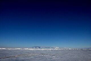
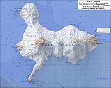
Ross Island is an island in Antarctica lying on the east side of McMurdo Sound and extending 43 nautical miles from Cape Bird on the north to Cape Armitage on the south, and a like distance from Cape Royds on the west to Cape Crozier on the east. The island is entirely volcanic. Mount Erebus, 3,795 metres (12,451 ft), near the center, is an active volcano. Mount Terror, 3,230 metres (10,600 ft), about 20 nautical miles eastward, is an extinct volcano. Mount Bird rises to 1,765 metres (5,791 ft) just south of Cape Bird. Ross Island lies within the boundary of Ross Dependency, an area of Antarctica claimed by New Zealand.

Mount Erebus is the second-highest volcano in Antarctica, the highest active volcano in Antarctica, and the southernmost active volcano on Earth. It is the sixth-highest peak of an island and the second most prominent mountain in Antarctica after Mount Vinson. It has a summit elevation of 3,794 metres (12,448 ft). It is located in the Ross Dependency on Ross Island, which is also home to three inactive volcanoes: Mount Terror, Mount Bird, and Mount Terra Nova. The mountain was named by Captain James Clark Ross in 1841 for his ship, HMS Erebus.

Mount Terror is an extinct volcano about 3,230 metres (10,600 ft) high on Ross Island, Antarctica, about 20 nautical miles eastward of Mount Erebus. Mount Terror was named in 1841 by polar explorer Sir James Clark Ross for his second ship, HMS Terror. The captain of Terror was Francis Crozier, a close friend of Ross for whom the nearby Cape Crozier is named.
The Dennistoun Glacier is a glacier, 50 nautical miles long, draining the northern slopes of Mount Black Prince, Mount Royalist and Mount Adam in the Admiralty Mountains of Victoria Land, Antarctica. It flows northwest between the Lyttelton Range and Dunedin Range, turning east on rounding the latter range to enter the sea south of Cape Scott.

Bowers Mountains is a group of north–south trending mountains in Antarctica, about 90 nautical miles long and 35 nautical miles wide, bounded by the coast on the north and by the Rennick Glacier, Canham Glacier, Black Glacier and Lillie Glacier in other quadrants. They are west of the Usarp Mountains, north of the Freyberg Mountains, northeast of the Concord Mountains, east of the Anare Mountains.

The Royal Society Range is a majestic range of mountains in Victoria Land, Antarctica, rising to 4,025 metres (13,205 ft) along the west shore of McMurdo Sound between the Koettlitz, Skelton and Ferrar Glaciers. They are south of the Kukri Hills, southeast of the Quartermain Mountains, and northeast of the Worcester Range.
White Island is an island in the Ross Archipelago of Antarctica. It is 15 nautical miles long, protruding through the Ross Ice Shelf immediately east of Black Island. It was discovered by the British National Antarctic Expedition (1901–04) and so named by them because of the mantle of snow that covers it.

Black Island, is an island in the Ross Archipelago, 12 nautical miles long, projecting through the Ross Ice Shelf to a height of 1,040 metres (3,410 ft).meters. It was discovered by the British National Antarctic Expedition and named by them for its appearance. The island is largely ice free and principally composed of black volcanic rock. The island's northernmost point is named Cape Hodgson, commemorating Thomas Vere Hodgson, one of the oldest members of the Discovery Expedition.

Hut Point Peninsula is a long, narrow peninsula from 2 to 3 nautical miles wide and 15 nautical miles long, projecting south-west from the slopes of Mount Erebus on Ross Island, Antarctica. McMurdo Station (US) and Scott Base (NZ) are Antarctic research stations located on the Hut Point Peninsula.
Mount Bird is a 1,765 metres (5,791 ft) high shield volcano standing about 7 nautical miles south of Cape Bird, the northern extremity of Ross Island. It was mapped by the British National Antarctic Expedition, 1901–04, under Robert Falcon Scott, and apparently named by them after Cape Bird.
Minna Bluff is a narrow, bold peninsula, 25 nautical miles long and 3 nautical miles wide, projecting southeast from Mount Discovery into the Ross Ice Shelf, Antarctica. It was discovered by the British National Antarctic Expedition (1901-04) which named it for Minna, the wife of Sir Clements Markham, the "father" of the expedition. It culminates in a south-pointing hook feature, and is the subject of research into Antarctic cryosphere history, funded by the National Science Foundation, Office of Polar Programs.
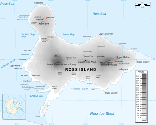
Cape Crozier is the most easterly point of Ross Island in Antarctica. It was discovered in 1841 during James Clark Ross's polar expedition of 1839 to 1843 with HMS Erebus and HMS Terror, and was named after Commander Francis Crozier, captain of HMS Terror, one of the two ships of Ross' expedition.

Mount Lister is a massive mountain, 4,025 metres (13,205 ft) high, forming the highest point in the Royal Society Range of Victoria Land, Antarctica. It was discovered by the British National Antarctic Expedition (1901–1904) which named it for Lord Joseph Lister, President of the Royal Society, 1895–1900.
The Kyle Hills are a prominent group of volcanic cones, hills, ridges, and peaks that occupy the eastern part of Ross Island, Antarctica, between Mount Terror and Cape Crozier. The hills extend east–west for 8 nautical miles (15 km), rising from sea level at Cape Crozier to about 2,600 metres (8,500 ft) in Mount McIntosh at the western end of the group. Local relief of features is on the order of 200 metres (660 ft).
Wood Bay is a large bay which is bounded by Cape Johnson and Aviator Glacier Tongue on the north, and Cape Washington on the south, along the coast of Victoria Land, Antarctica. It was discovered in 1841 by Captain James Clark Ross, Royal Navy, and named by him for Lieutenant James F.L. Wood of the ship HMS Erebus.
Windless Bight is a prominent bight that indens the south side of Ross Island, Antarctica, eastward of Hut Point Peninsula. It was named by the Winter Journey Party, led by Wilson, of the British Antarctic Expedition, 1910–13, which encountered no wind in this area. The bight is permanently frozen. It is the site of a station that monitors infrasound to detect violations of the Comprehensive Nuclear-Test-Ban Treaty.
Barnett Glacier is a large glacier in the Anare Mountains that flows east along the south side of Tapsell Foreland into Smith Inlet, northern Victoria Land, Antarctica.
The Marshall Mountains are a group of mountains overlooking Beardmore Glacier in the Queen Alexandra Range, Antarctica. They are bounded on the north by Berwick Glacier, and on the south by Swinford Glacier.
Saint Johns Range is a crescent-shaped mountain range about 20 nautical miles long, in Victoria Land, Antarctica. It is bounded on the north by the Cotton Glacier, Miller Glacier and Debenham Glacier, and on the south by Victoria Valley and the Victoria Upper Glacier and Victoria Lower Glacier.
Lewis Bay is a bay indenting the north coast of Ross Island, Antarctica, between Mount Bird and Cape Tennyson.

