Nimrod Glacier

Last updated • 6 min readFrom Wikipedia, The Free Encyclopedia
The Nimrod Glacier flowing around an ice peak seen by TerraSAR-X.jpg
Satellite image of the Nimrod Glacier flowing round the Kon-Tiki Nunatak.
Antarctica relief location map.jpg
Red pog.svg
Coordinates 82°21′S163°00′E / 82.350°S 163.000°E / -82.350; 163.000 (Nimrod Glacier)
Length135 kilometres (84 mi)
Terminus Ross Ice Shelf

The Nimrod Glacier ( 82°21′S163°00′E / 82.350°S 163.000°E / -82.350; 163.000 (Nimrod Glacier) ) is a major glacier about 85 nautical miles (157 km; 98 mi) long, flowing from the polar plateau in a northerly direction through the Transantarctic Mountains into the Ross Ice Shelf, Antarctica. [1]

Contents

Location

The Nimrod Glacier flows north between the Geologists and Miller Ranges, then northeasterly between the Churchill Mountains and Queen Elizabeth Range, and finally spills into Shackleton Inlet and the Ross Ice Shelf between Capes Wilson and Lyttelton. It was photographed from the air by USN Operation Highjump, 1946–47. The name, given by US-ACAN, is in association with Shackleton Inlet and is for the Nimrod , the ship of the British Antarctic Expedition (1907–09) under Ernest Shackleton. [1] The mouth of the glacier is southeast of the Starshot Glacier and the Nursery Glacier. [2] It is north of Robb Glacier. [3]

Icefalls

Worsley Icefalls

82°57′S155°00′E / 82.950°S 155.000°E / -82.950; 155.000 Icefalls near the head of Nimrod Glacier. Seen by the northern party of the NZGSAE (1961-62) and presumbably named for Frank Worsley, member of the British Trans-Antarctic Expedition, 1914-16, and Shackleton-Rowett Antarctic Expedition, 1921-22. [4]

Cooper Icefalls

82°31′S160°00′E / 82.517°S 160.000°E / -82.517; 160.000 . The main icefalls of the Nimrod Glacier, in the vicinity of Kon-Tiki Nunatak. Named by the southern party of the NZGSAE (1960-61) for Christopher Neville Cooper, a member of the expedition, and also a member of the New Zealand Alpine Club Antarctic Expedition, 1959-60. [5]

Left tributaries

Lower Nimrod Glacier C82195s1 Ant.Map Nimrod Glacier.jpg
Lower Nimrod Glacier
Geologists Range and upper Nimrod Glacier C82202s5 Ant.Map Geologists Range.jpg
Geologists Range and upper Nimrod Glacier
Miller Range and Marsh Glacier C83165s1 Ant.Map Mount Rabot.jpg
Miller Range and Marsh Glacier

Tributaries from the left (Churchill Mountains) side are, from east to west:

Algie Glacier

82°08′S162°05′E / 82.133°S 162.083°E / -82.133; 162.083 . Glacier about 25 miles (40 km) long, flowing southeast into Nimrod Glacier just west of Nash Range. Named by the New Zealand Ross Sea Committee for the Hon. R.M. Algie who, as Minister in Charge of Scientific and Industrial Research, gave his strong support to the New Zealand party of the CTAE, 1956-58. [6]

Errant Glacier

82°21′S160°58′E / 82.350°S 160.967°E / -82.350; 160.967 . Glacier, 15 miles (24 km) long, which lies on the east side of Holyoake Range and drains south into Nimrod Glacier. This glacier offered a route to the southern party of the NZGSAE (1960-61) when they journeyed north from Nimrod Glacier in December 1960. Named by them to describe the zigzag route of the party in traveling on the glacier in search for a route north. [7]

Prince Philip Glacier

82°21′S159°55′E / 82.350°S 159.917°E / -82.350; 159.917 . Glacier flowing south for about 20 miles (32 km) between Cobham and Holyoake ranges into Nimrod Glacier. Named by the NZ-APC for Prince Philip, Duke of Edinburgh, husband of Queen Elizabeth II. [8]

Gray Glacier

82°23′S159°35′E / 82.383°S 159.583°E / -82.383; 159.583 . A glacier in the Cobham Range, 6 miles (9.7 km) long, lying south of Tarakanov Ridge and flowing southeast to merge with Prince Philip Glacier where the two join the Nimrod Glacier. Named by the Holyoake, Cobham, and Queen Elizabeth Ranges party of the NZGSAE (1964-65) for M. Gray, postmaster and assistant radio officer at Scott Base, 1965. [9]

The Slot

82°40′S155°05′E / 82.667°S 155.083°E / -82.667; 155.083 . A small swift glacier descending from the polar plateau between Mount Ronca and Mount Summerson in the Geologists Range. Seen by the northern party of the NZGSAE (1961-62) and so named because of its narrowness and crevassed nature. [10]

Lucy Glacier

82°24′S158°25′E / 82.400°S 158.417°E / -82.400; 158.417 . A wide glacier which flows southeast from the polar plateau, between Laird Plateau and McKay Cliffs, into Nimrod Glacier. Named for W.R. Lucy, surveyor with 1963-64 Scott Base projects, who wintered over in 1964, and was surveyor with the 1964-65 Geologists Range field party of the NZGSAE. [11]

On December 31, 1993, a ski-equipped Hercules (LC-130) aircraft crashed on Lucy Glacier, near Mount Isbell. The aircraft was retrieving a group from the University of Wisconsin–Milwaukee who had spent six weeks investigating the geology in the mountains between the Byrd Glacier and Nimrod Glacier. The group consisted of Gina Seegers-Szablewski, Greg Gelhar, mountaineer Shaun Norman (New Zealand), and John Isbell.[ citation needed ]

Right tributaries

Tributaries from the right (Queen Elizabeth Range) side are, from east to west:

Lowery Glacier

82°35′S163°15′E / 82.583°S 163.250°E / -82.583; 163.250 . Glacier about 60 miles (97 km) long, which flows north from Prince Andrew Plateau along the east side of Queen Elizabeth Range to enter Nimrod Glacier. Named by the N.Z Geological and Topographical Survey Expedition (1959-60) for J.H. Lowery who, as a member of a field party, suffered injuries when a Sno-cat broke through a crevasse bridge off Cape Selborne in November 1959. [12]

Doss Glacier

82°30′S162°21′E / 82.500°S 162.350°E / -82.500; 162.350 . A small glacier just east of Mount Boman, flowing into Nimrod Glacier from the north slopes of the Queen Elizabeth Range. Mapped by the USGS from tellurometer surveys and Navy air photos, 1960-62. Named by US-ACAN for Edgar L. Doss, USARP glaciologist at Roosevelt Island, 1962-63. [13]

Tranter Glacier

82°32′S161°45′E / 82.533°S 161.750°E / -82.533; 161.750 . A glacier in the north part of Queen Elizabeth Range, draining into Nimrod Glacier between Mount Chivers and Mount Boman. Mapped by the USGS from tellurometer surveys and Navy air photos, 1960-62. Named by US-ACAN for David L. Tranter, USARP glaciologist at Roosevelt Island, 1962-63. [14]

Otago Glacier

82°32′S161°0′E / 82.533°S 161.000°E / -82.533; 161.000 Glacier about 20 miles (32 km) long draining the northeast side of Mount Markham and entering Nimrod Glacier just east of Svaton Peaks. Named by the northern party of the NZGSAE (1961-62) for Otago University, New Zealand. [15]

Heilman Glacier

82°37′S160°46′E / 82.617°S 160.767°E / -82.617; 160.767 . A glacier in the north part of Queen Elizabeth Range, flowing northwest from Mount Sandved into Nimrod Glacier. Mapped by the USGS from tellurometer surveys and Navy air photos, 1960-62. Named by US-ACAN for William L. Heilman, USARP glaciologist at Roosevelt Island, 1961-62. [16]

Hamilton Glacier

82°40′S160°15′E / 82.667°S 160.250°E / -82.667; 160.250 . A glacier about 12 miles (19 km) long flowing from the northwest slopes of Markham Plateau in the Queen Elizabeth Range into Nimrod Glacier. Named by the northern party of the NZGSAE (1960-61) for W.M. Hamilton, Secretary of the New Zealand Dept. of Scientific and Industrial Research. [17]

Marsh Glacier

82°52′S158°30′E / 82.867°S 158.500°E / -82.867; 158.500 . Glacier about 70 miles (110 km) long, flowing north from the polar plateau between the Miller Range and Queen Elizabeth Range into Nimrod Glacier. Seen by a New Zealand party of the CTAE (1956-58) and named for G.W. Marsh, a member of the party. [18]

See also

Related Research Articles

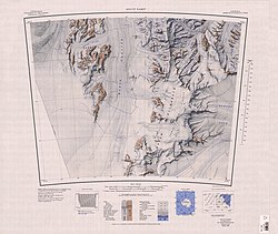
Mount Markham is a twin-peaked massif surmounting the north end of the Markham Plateau in the Queen Elizabeth Range of Antarctica. The peaks have elevations of 4,350 metres (14,270 ft) and 4,280 metres (14,040 ft).

The Queen Elizabeth Range is a rugged mountain range that parallels the eastern side of Marsh Glacier for nearly 100 nmi from Nimrod Glacier in the north to Law Glacier in the south. Mount Markham, 4,350 metres (14,270 ft) high, is the highest elevation in the range.

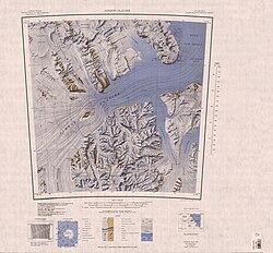
The Geologists Range is a mountain range about 55 km (34 mi) long, standing between the heads of Lucy and Nimrod Glaciers in Antarctica. Seen by the northern party of the New Zealand Geological Survey Antarctic Expedition (NZGSAE) (1961–62) and named to commemorate the work of geologists in Antarctic exploration. The Churchill Mountains are to the north, the Queen Elizabeth Range to the east and the Miller Range to the southeast

<span class="mw-page-title-main">Churchill Mountains</span> Mountain range in Antarctica

The Churchill Mountains is a major range of mountains and associated elevations bordering the western side of the Ross Ice Shelf, between Byrd Glacier and Nimrod Glacier. They are south of the Britannia Range and north of the Geologists Range, Miller Range and Queen Elizabeth Range.

Lennox-King Glacier is a large valley glacier, about 40 nautical miles (70 km) long that flows east into the Ross Ice Shelf.

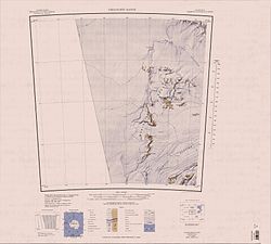
Surveyors Range is a 30 miles (48 km) long mountain range in the Churchill Mountains of Antarctica.

Prince Andrew Plateau is an ice-covered plateau, about 40 nautical miles long and 15 nautical miles wide, lying south of Mount Rabot in the Queen Elizabeth Range of Antarctica.

Rennick Glacier is broad glacier, nearly 200 nautical miles long, which is one of the largest in Antarctica. It rises on the polar plateau westward of Mesa Range and is 20 to 30 nautical miles wide, narrowing to 10 nautical miles near the coast. It takes its name from Rennick Bay where the glacier reaches the sea.

The Carnegie Range is a mountain range in the Churchill Mountains of the Transantarctic Mountains System, in the Ross Dependency of Antarctica.

<span class="mw-page-title-main">Cobham Range</span> Mountain range in Antarctica

The Cobham Range is a mountain range in the Churchill Mountains of the Ross Dependency, Antarctica. It extends to the north of the Nimrod Glacier.

<span class="mw-page-title-main">Nash Range</span> Coastal range in the Churchill Mountains of Antarctica

The Nash Range is a mainly ice-covered coastal range in the Churchill Mountains of Antarctica.

Cotton Plateau is a snow-covered plateau just east of the mouth of Marsh Glacier, in the Queen Elizabeth Range.

Svaton Peaks is a cluster of rugged peaks at the north end of the Queen Elizabeth Range, Antarctica, surmounting the area between the mouths of the Heilman Glacier and Otago Glacier.

The Frigate Range is a high mountain range extending 12 nautical miles (22 km) east from Mount Markham in the Queen Elizabeth Range of Antarctica.

Lowery Glacier is a glacier about 60 nautical miles (110 km) long, a tributary of the Nimrod Glacier, which enters the west of the Ross Ice Shelf, Antarctica.

Starshot Glacier is a glacier 50 nautical miles (90 km) long that flows through the Churchill Mountains to enter the Ross Ice Shelf in Antarctica.

The Holland Range is a rugged coastal mountain range in the Ross Dependency, Antarctica, on the west coast of the Ross Ice Shelf. It is about 60 nautical miles (110 km) long.

Holyoake Range is a mountain range in the Ross Dependency of Antarctice. It is in the southern section of the Churchill Mountains, part of the Transantarctic Mountains System.

Cape Lyttelton is a cape forming the southern entrance point of Shackleton Inlet, along the western edge of the Ross Ice Shelf, Antarctica.

Robb Glacier is a glacier about 40 nautical miles (70 km) long that flows through the Ross Dependency to enter the west coast of the Ross Ice Shelf in Antarctica.

References

  1. 1 2 Alberts 1995, p. 527.
  2. Mount Nares USGS.
  3. Holland Range USGS.
  4. Alberts 1995, p. 824.
  5. Alberts 1995, p. 151.
  6. Alberts 1995, p. 12.
  7. Alberts 1995, p. 224.
  8. Alberts 1995, p. 591.
  9. Alberts 1995, p. 292.
  10. Alberts 1995, p. 685.
  11. Alberts 1995, p. 446.
  12. Alberts 1995, p. 445.
  13. Alberts 1995, p. 196.
  14. Alberts 1995, p. 757.
  15. Alberts 1995, p. 549.
  16. Alberts 1995, p. 323.
  17. Alberts 1995, p. 308.
  18. Alberts 1995, p. 464.

Sources