The geography of Antarctica is dominated by its south polar location and, thus, by ice. The Antarctic continent, located in the Earth's southern hemisphere, is centered asymmetrically around the South Pole and largely south of the Antarctic Circle. It is washed by the Southern Ocean or, depending on definition, the southern Pacific, Atlantic, and Indian Oceans. It has an area of more than 14.2 million km2. Antarctica is the largest ice desert in the world.
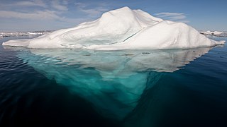
An iceberg is a piece of fresh water ice more than 15 meters long that has broken off a glacier or an ice shelf and is floating freely in open water. Smaller chunks of floating glacially derived ice are called "growlers" or "bergy bits". Much of an iceberg is below the water's surface, which led to the expression "tip of the iceberg" to illustrate a small part of a larger unseen issue. Icebergs are considered a serious maritime hazard.

The climate of Antarctica is the coldest on Earth. The continent is also extremely dry, averaging 166 mm (6.5 in) of precipitation per year. Snow rarely melts on most parts of the continent, and, after being compressed, becomes the glacier ice that makes up the ice sheet. Weather fronts rarely penetrate far into the continent, because of the katabatic winds. Most of Antarctica has an ice-cap climate with extremely cold and dry weather.

The Ross Ice Shelf is the largest ice shelf of Antarctica. It is several hundred metres thick. The nearly vertical ice front to the open sea is more than 600 kilometres (370 mi) long, and between 15 and 50 metres high above the water surface. Ninety percent of the floating ice, however, is below the water surface.

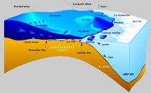
An ice shelf is a large platform of glacial ice floating on the ocean, fed by one or multiple tributary glaciers. Ice shelves form along coastlines where the ice thickness is insufficient to displace the more dense surrounding ocean water. The boundary between the ice shelf (floating) and grounded ice is referred to as the grounding line; the boundary between the ice shelf and the open ocean is the ice front or calving front.

In glaciology, an ice sheet, also known as a continental glacier, is a mass of glacial ice that covers surrounding terrain and is greater than 50,000 km2 (19,000 sq mi). The only current ice sheets are the Antarctic ice sheet and the Greenland ice sheet. Ice sheets are bigger than ice shelves or alpine glaciers. Masses of ice covering less than 50,000 km2 are termed an ice cap. An ice cap will typically feed a series of glaciers around its periphery.

The Amundsen Sea is an arm of the Southern Ocean off Marie Byrd Land in western Antarctica. It lies between Cape Flying Fish to the east and Cape Dart on Siple Island to the west. Cape Flying Fish marks the boundary between the Amundsen Sea and the Bellingshausen Sea. West of Cape Dart there is no named marginal sea of the Southern Ocean between the Amundsen and Ross Seas. The Norwegian expedition of 1928–1929 under Captain Nils Larsen named the body of water for the Norwegian polar explorer Roald Amundsen while exploring this area in February 1929.

The Antarctic Peninsula, known as O'Higgins Land in Chile and Tierra de San Martín in Argentina, and originally as Graham Land in the United Kingdom and the Palmer Peninsula in the United States, is the northernmost part of mainland Antarctica.

Roosevelt Island is the second largest ice rise of Antarctica and world-wide, after Berkner Island. Despite its name, it is not an island, since the bedrock below the ice at its highest part is below sea level. It is about 130 km (81 mi) long in a NW-SE direction, 65 km (40 mi) wide and about 7,500 km2 (2,896 sq mi) in area, lying under the eastern part of the Ross Ice Shelf of Antarctica. Its central ridge rises to about 550 m (1,804 ft) above sea level, but this and all other elevations of the ice rise are completely covered by ice, so that it is invisible at ground level.
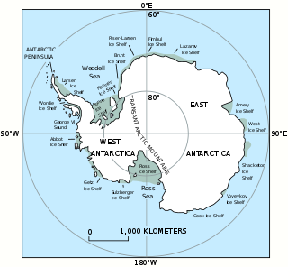
The West Antarctic Ice Sheet (WAIS) is the segment of the continental ice sheet that covers West Antarctica, the portion of Antarctica on the side of the Transantarctic Mountains that lies in the Western Hemisphere. It is classified as a marine-based ice sheet, meaning that its bed lies well below sea level and its edges flow into floating ice shelves. The WAIS is bounded by the Ross Ice Shelf, the Ronne Ice Shelf, and outlet glaciers that drain into the Amundsen Sea.

The Larsen Ice Shelf is a long ice shelf in the northwest part of the Weddell Sea, extending along the east coast of the Antarctic Peninsula from Cape Longing to Smith Peninsula. It is named after Captain Carl Anton Larsen, the master of the Norwegian whaling vessel Jason, who sailed along the ice front as far as 68°10' South during December 1893. In finer detail, the Larsen Ice Shelf is a series of shelves that occupy distinct embayments along the coast. From north to south, the segments are called Larsen A, Larsen B, and Larsen C by researchers who work in the area. Further south, Larsen D and the much smaller Larsen E, F and G are also named.

Marie Byrd Land (MBL) is an unclaimed region of Antarctica. With an area of 1,610,000 km2 (620,000 sq mi), it is the largest unclaimed territory on Earth. It was named after the wife of American naval officer Richard E. Byrd, who explored the region in the early 20th century.

The Amery Ice Shelf is a broad ice shelf in Antarctica at the head of Prydz Bay between the Lars Christensen Coast and Ingrid Christensen Coast. It is part of Mac. Robertson Land. The name "Cape Amery" was applied to a coastal angle mapped on 11 February 1931 by the British Australian New Zealand Antarctic Research Expedition (BANZARE) under Douglas Mawson. He named it for William Bankes Amery, a civil servant who represented the United Kingdom government in Australia (1925–28). The Advisory Committee on Antarctic Names interpreted this feature to be a portion of an ice shelf and, in 1947, applied the name Amery to the whole shelf.

Pine Island Glacier (PIG) is a large ice stream, and the fastest melting glacier in Antarctica, responsible for about 25% of Antarctica's ice loss. The glacier ice streams flow west-northwest along the south side of the Hudson Mountains into Pine Island Bay, Amundsen Sea, Antarctica. It was mapped by the United States Geological Survey (USGS) from surveys and United States Navy (USN) air photos, 1960–66, and named by the Advisory Committee on Antarctic Names (US-ACAN) in association with Pine Island Bay.

Thwaites Glacier is an unusually broad and vast Antarctic glacier located east of Mount Murphy, on the Walgreen Coast of Marie Byrd Land. It was initially sighted by polar researchers in 1940, mapped in 1959–1966 and officially named in 1967, after the late American glaciologist Fredrik T. Thwaites. The glacier flows into Pine Island Bay, part of the Amundsen Sea, at surface speeds which exceed 2 kilometres (1.2 mi) per year near its grounding line. Its fastest-flowing grounded ice is centered between 50 and 100 kilometres east of Mount Murphy. Like many other parts of the cryosphere, it has been adversely affected by climate change, and provides one of the more notable examples of the retreat of glaciers since 1850.

The Nordenskjöld Coast is located on the Antarctic Peninsula, more specifically Graham Land, which is the top region of the Peninsula. The Peninsula is a thin, long ice sheet with an Alpine-style mountain chain. The coast consists of 15m tall ice cliffs with ice shelves.

Antarctica is Earth's southernmost and least-populated continent. Situated almost entirely south of the Antarctic Circle and surrounded by the Southern Ocean, it contains the geographic South Pole. Antarctica is the fifth-largest continent, being about 40% larger than Europe, and has an area of 14,200,000 km2 (5,500,000 sq mi). Most of Antarctica is covered by the Antarctic ice sheet, with an average thickness of 1.9 km (1.2 mi).

Ice calving, also known as glacier calving or iceberg calving, is the breaking of ice chunks from the edge of a glacier. It is a form of ice ablation or ice disruption. It is the sudden release and breaking away of a mass of ice from a glacier, iceberg, ice front, ice shelf, or crevasse. The ice that breaks away can be classified as an iceberg, but may also be a growler, bergy bit, or a crevasse wall breakaway.

The Riiser-Larsen Sea is one of the marginal seas located in the Southern Ocean off East Antarctica and south of the Indian Ocean. It is delimited Astrid Ridge in the west and the Gunnerus Ridge and the Kainanmaru Bank in the east. It is bordered by the Lazarev Sea to the west and the Cosmonauts Sea to the east, or between 14°E and 30°E. Its northern border is defined to be the 65th parallel south. The name, proposed by the Soviet Union, was never officially approved by the International Hydrographic Organization (IHO).

Lake Washburn is a lake that formerly existed in the Taylor Valley, McMurdo Dry Valleys, Antarctica. It formed when climatic changes and an expansion of ice caused the flooding of the valley, between 23,000 and 8,340 radiocarbon years ago. Its extent and elevation are unclear but Lake Bonney and Lake Fryxell are considered to be its present-day remnant.