Related Research Articles
Skelton Glacier is a large glacier flowing from the polar plateau into the Ross Ice Shelf at Skelton Inlet on the Hillary Coast, south of Victoria Land, Antarctica.

The Priestley Glacier is a major valley glacier, about 60 nautical miles long, originating at the edge of the Polar Plateau of Victoria Land, Antarctica. The glacier drains southeast between the Deep Freeze Range and Eisenhower Range to enter the northern end of the Nansen Ice Sheet. It was first explored by the Northern Party of the British Antarctic Expedition, 1910–13, and named for Raymond Priestley, a geologist with the Northern Party.
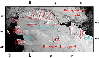
The Abbot Ice Shelf is an ice shelf 250 nautical miles long and 40 nautical miles wide, bordering Eights Coast from Cape Waite to Pfrogner Point in Antarctica. Thurston Island lies along the northern edge of the western half of this ice shelf; other sizable islands lie partly or wholly within this shelf.

Toney Mountain is an elongated snow-covered shield volcano, 38 nautical miles long and rising to 3,595 metres (11,795 ft) at Richmond Peak, located 35 nautical miles southwest of Kohler Range in Marie Byrd Land, Antarctica.
Smith Glacier (75°05′S112°00′W is a low-gradient Antarctic glacier, over 160 km long, draining from Toney Mountain in an ENE direction to Amundsen Sea. A northern distributary, Kohler Glacier, drains to Dotson Ice Shelf but the main flow passes to the sea between Bear Peninsula and Mount Murphy, terminating at Crosson Ice Shelf.

The Usarp Mountains are a major mountain range in North Victoria Land, Antarctica. They are west of the Rennick Glacier and trend north to south for about 190 kilometres (118 mi). The mountains are bounded to the north by Pryor Glacier and the Wilson Hills. They are west of the Bowers Mountains.
Rymill Bay is a bay, 9 nautical miles wide at its mouth and indenting 5 nautical miles between Red Rock Ridge and Bertrand Ice Piedmont along the west coast of Graham Land, Antarctica.

Lambert Glacier is a major glacier in East Antarctica. At about 80 km (50 mi) wide, over 400 km (250 mi) long, and about 2,500 m (8,200 ft) deep, it is the world's largest glacier. It drains 8% of the Antarctic ice sheet to the east and south of the Prince Charles Mountains and flows northward to the Amery Ice Shelf. It flows in part of Lambert Graben and exits the continent at Prydz Bay.

The Prince Charles Mountains are a major group of mountains in Mac. Robertson Land in Antarctica, including the Athos Range, the Porthos Range, and the Aramis Range. The highest peak is Mount Menzies, with a height of 3,228 m (10,591 ft). Other prominent peaks are Mount Izabelle and Mount Stinear. These mountains, together with other scattered peaks, form an arc about 420 km (260 mi) long, extending from the vicinity of Mount Starlight in the north to Goodspeed Nunataks in the south.
The Mariner Glacier is a major glacier over 60 nautical miles long, descending southeast from the plateau of Victoria Land, Antarctica, between Mountaineer Range and Malta Plateau, and terminating at Lady Newnes Bay, Ross Sea, where it forms the floating Mariner Glacier Tongue.

Wilkins Sound is a seaway in Antarctica that is largely occupied by the Wilkins Ice Shelf. It is located on the southwest side of the Antarctic Peninsula between the concave western coastline of Alexander Island and the shores of Charcot Island and Latady Island farther to the west.
Bryan Coast is that portion of the coast of Antarctica along the south shore of the Bellingshausen Sea between Pfrogner Point and the northern tip of the Rydberg Peninsula. To the west is Eights Coast, and to the east is English Coast.
Carroll Inlet is an inlet, 40 nautical miles long and 6 nautical miles wide, trending southeast along the coast of Ellsworth Land, Antarctica, between the Rydberg Peninsula and Smyley Island. The head of the inlet is divided into two arms by the presence of Case Island and is bounded to the east by Stange Ice Shelf.
The Cayley Glacier is a glacier flowing northwest into the south side of Brialmont Cove, on the west coast of Graham Land, Antarctica.
Coulter Heights are snow-covered heights that rise between Strauss Glacier and Frostman Glacier near the coast of Marie Byrd Land, Antarctica. The rock outcrops of Kuberry Rocks, Matikonis Peak and Lambert Nunatak protrude above the snow surface of the heights.
Violante Inlet is an ice-filled inlet 16 nautical miles long, in an east–west direction, and 12 to 15 nautical miles wide, lying between Cape Fanning and Cape Herdman along the east coast of Palmer Land, Antarctica.
Petrie Ice Rises is a group of ice rises extending in a north-south line, lying merged within the Wilkins Ice Shelf, to the west of Alexander Island, Antarctica. The group was seen from the air on a British Antarctic Survey (BAS) radio echo sounding flight around Alexander Island on 11 February 1967 and was later accurately positioned from US Landsat imagery. It was named by the United Kingdom Antarctic Place-Names Committee in 1980 after David L. Petrie, a BAS and Scott Polar Research Institute electronics technician, who was on the flight.
Dvořák Ice Rise is an ice rise 1.5 nautical miles (3 km) in extent, rising above the ice of Mendelssohn Inlet in the southwest part of Alexander Island, Antarctica. It was first mapped, from air photos taken by the Ronne Antarctic Research Expedition, 1947–48, by D. Searle of the Falkland Islands Dependencies Survey in 1960, and was named by the UK Antarctic Place-Names Committee after Antonín Dvořák, the Czech composer. (1841-1904).
Vere Ice Rise is a small ice rise lying merged within the Wilkins Ice Shelf, lying off the west coast of Alexander Island, Antarctica. It was roughly mapped from the air by British Antarctic Survey on a radio echo sounding flight on 1 February 1967, and later accurately positioned from U.S. Landsat imagery of February 1979. It was named by the United Kingdom Antarctic Place-Names Committee in 1980 after Flight Lieutenant Robert P. Vere, RAF, the second pilot of the Twin Otter aircraft used on the British Antarctic Survey flight.
Lehrke Inlet is an ice-filled inlet, 8 nautical miles wide, which recedes southwest for 17 nautical miles between Cape Boggs and Cape Sharbonneau, along the east coast of Palmer Land, Antarctica.
References
- ↑ "Burgess Ice Rise". SCAR Composite Gazetteer of Antarctica. Retrieved 22 January 2025.
 This article incorporates public domain material from "Burgess Ice Rise". Geographic Names Information System . United States Geological Survey.
| | This Alexander Island location article is a stub. You can help Wikipedia by expanding it. |