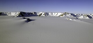
The Shackleton Range is a mountain range in Antarctica that rises to 1,875 metres (6,152 ft) and extends in an east–west direction for about 100 miles (160 km) between the Slessor and Recovery Glaciers.

The Byrd Glacier is a major glacier in Antarctica, about 136 km (85 mi) long and 24 km (15 mi) wide. It drains an extensive area of the Antarctic plateau, and flows eastward to discharge into the Ross Ice Shelf.
The Amundsen Glacier is a major Antarctic glacier, about 7 to 11 km wide and 150 km (80 nmi) long. It originates on the Antarctic Plateau where it drains the area to the south and west of Nilsen Plateau, then descends through the Queen Maud Mountains to enter the Ross Ice Shelf just west of the MacDonald Nunataks.
The Cook Mountains is a group of mountains bounded by the Mulock and Darwin glaciers in Antarctica. They are south of the Worcester Range and north of the Darwin Mountains and the Britannia Range.

The Brunt Ice Shelf borders the Antarctic coast of Coats Land between Dawson-Lambton Glacier and Stancomb-Wills Glacier Tongue. It was named by the UK Antarctic Place-names Committee after David Brunt, British meteorologist, Physical Secretary of the Royal Society, 1948–57, who was responsible for the initiation of the Royal Society Expedition to this ice shelf in 1955.

Mount Murphy is a massive, snow-covered mountain with steep, rocky slopes rising to 2,505 metres (8,219 ft) in Marie Byrd Land, Antarctica. It is directly south of Bear Peninsula and is bounded by Smith Glacier, Pope Glacier and Haynes Glacier. Volcanic activity began in the Miocene with the eruption of basaltic and trachytic lava. Volcanism on the slopes of the volcano resumed much later during the Pleistocene, with a parasitic cone having been K–Ar dated to 0.9 million years old.

Koettlitz Glacier is a large Antarctic glacier lying west of Mount Morning and Mount Discovery in the Royal Society Range, flowing from the vicinity of Mount Cocks northeastward between Brown Peninsula and the mainland into the ice shelf of McMurdo Sound.
Smith Glacier (75°05′S112°00′W is a low-gradient Antarctic glacier, over 160 km long, draining from Toney Mountain in an ENE direction to Amundsen Sea. A northern distributary, Kohler Glacier, drains to Dotson Ice Shelf but the main flow passes to the sea between Bear Peninsula and Mount Murphy, terminating at Crosson Ice Shelf.

The Getz Ice Shelf is an ice shelf over 300 nautical miles long and from 20 to 60 nautical miles wide, bordering the Hobbs Coast and Bakutis Coast of Marie Byrd Land, Antarctica, between the McDonald Heights and Martin Peninsula. Several large islands are partially or wholly embedded in the ice shelf.
Mount Bird is a 1,765 metres (5,791 ft) high shield volcano standing about 7 nautical miles south of Cape Bird, the northern extremity of Ross Island. It was mapped by the British National Antarctic Expedition, 1901–04, under Robert Falcon Scott, and apparently named by them after Cape Bird.
Surveyors Range is a 30 miles (48 km) long mountain range in the Churchill Mountains of Antarctica.
The Mulock Glacier is a large, heavily crevassed glacier which flows into the Ross Ice Shelf 40 kilometers south of the Skelton Glacier in the Ross Dependency, Antarctica.

Crane Glacier, is a narrow glacier which flows 30 miles (50 km) in an east-northeasterly direction along the northwest side of Aristotle Mountains to enter Spillane Fjord south of Devetaki Peak, on the east coast of the Antarctic Peninsula. Sir Hubert Wilkins photographed this feature from the air in 1928 and gave it the name "Crane Channel", after C.K. Crane of Los Angeles, reporting that it appeared to be a channel cutting in an east-west direction across the peninsula. The name was altered to "Crane Inlet" following explorations along the west coast of the peninsula in 1936 by the British Graham Land Expedition, which proved that no through channel from the east coast existed as indicated by Wilkins. Comparison of Wilkins' photograph of this feature with those taken in 1947 by the Falklands Islands Dependencies Survey shows that Wilkins' "Crane Channel" is this glacier, although it lies about 75 miles (120 km) northeast of the position originally reported by Wilkins.
The Willett Range is the range extending north from Mistake Peak and running for 20 nautical miles as a high shelf along the edge of the continental ice to the Mackay Glacier, in Victoria Land. The range is breached by several glaciers flowing east from the plateau.
Mount Aldrich is a massive, somewhat flat-topped mountain standing at the east side of Ragotzkie Glacier in the Britannia Range, Antarctica.
Kosco Glacier is a glacier about 20 nautical miles long, flowing from the Anderson Heights vicinity of the Bush Mountains of Antarctica northward to enter the Ross Ice Shelf between Wilson Portal and Mount Speed.
The Gonville and Caius Range is a range of peaks, 1,000 to 1,500 metres high, between Mackay Glacier and Debenham Glacier in Victoria Land, Antarctica.
The Harold Byrd Mountains are a group of exposed mountains and nunataks which extend in an east–west direction between the lower part of Leverett Glacier and the head of the Ross Ice Shelf in Antarctica. They were discovered in December 1929 by the Byrd Antarctic Expedition geological party under Laurence Gould, and named by Rear Admiral Richard E. Byrd for D. Harold Byrd, a cousin of his and a contributor towards the purchase of furs for the expedition.
The Medina Peaks are rugged, mainly ice-free, peaks surmounting a ridge 15 nautical miles long, extending north along the east side of Goodale Glacier to the edge of the Ross Ice Shelf, Antarctica.
Starshot Glacier is a glacier 50 nautical miles (90 km) long that flows through the Churchill Mountains to enter the Ross Ice Shelf in Antarctica.


