Bach Ice Shelf

Last updated

The ice shelves of the Antarctic peninsula. Bach in the lower left. Antarctic-Peninsula-Ice-Shelves.png
The ice shelves of the Antarctic peninsula. Bach in the lower left.

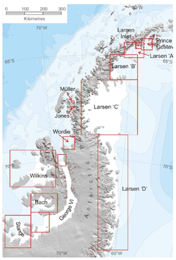
The Bach Ice Shelf ( 72°S72°W / 72°S 72°W / -72; -72 ) is an ice shelf which is irregular in shape and 45 miles (72 km) in extent, occupying an embayment in the south part of Alexander Island entered between Berlioz Point and Rossini Point. The ice shelf supports the south face of the Beethoven Peninsula, along with some minor extensive peninsulas and small inlets (Weber Inlet, Boccherini Inlet etc.) Bach ice shelf also supports the north side of the Monteverdi Peninsula. A minor embayment in this position first appeared on the charts of the US Antarctic Service, which explored the south part of Alexander Island by air and from the ground in 1940. The ice shelf was delineated by Derek J.H. Searle of the Falkland Islands Dependencies Survey in 1960, from air photos taken by the 194748 Ronne Antarctic Research Expedition. It was named by the UK Antarctic Place-Names Committee after the German composer Johann Sebastian Bach.

Contents

In a 2009 review, the Bach Ice Shelf was listed as one of 5 Antarctic peninsula Ice shelves that were not retreating. However, with the retreat of the Wilkins Ice Shelf possibly signalling a southward retreat of the limit of viability, Bach Ice Shelf may be the next to come under threat. [1]

Further reading

Related Research Articles

<span class="mw-page-title-main">Geography of Antarctica</span>

The geography of Antarctica is dominated by its south polar location and, thus, by ice. The Antarctic continent, located in the Earth's southern hemisphere, is centered asymmetrically around the South Pole and largely south of the Antarctic Circle. It is washed by the Southern Ocean or, depending on definition, the southern Pacific, Atlantic, and Indian Oceans. It has an area of more than 14.2 million km2. Antarctica is the largest ice desert in the world.

<span class="mw-page-title-main">Climate of Antarctica</span>

The climate of Antarctica is the coldest on Earth. The continent is also extremely dry, averaging 166 mm (6.5 in) of precipitation per year. Snow rarely melts on most parts of the continent, and, after being compressed, becomes the glacier ice that makes up the ice sheet. Weather fronts rarely penetrate far into the continent, because of the katabatic winds. Most of Antarctica has an ice-cap climate with extremely cold and dry weather.

<span class="mw-page-title-main">Ice shelf</span> Large platform of glacial ice

An ice shelf is a large platform of glacial ice floating on the ocean, fed by one or multiple tributary glaciers. Ice shelves form along coastlines where the ice thickness is insufficient to displace the more dense surrounding ocean water. The boundary between the ice shelf (floating) and grounded ice is referred to as the grounding line; the boundary between the ice shelf and the open ocean is the ice front or calving front.

<span class="mw-page-title-main">Amundsen Sea</span> Arm of the Southern Ocean

The Amundsen Sea is an arm of the Southern Ocean off Marie Byrd Land in western Antarctica. It lies between Cape Flying Fish to the east and Cape Dart on Siple Island to the west. Cape Flying Fish marks the boundary between the Amundsen Sea and the Bellingshausen Sea. West of Cape Dart there is no named marginal sea of the Southern Ocean between the Amundsen and Ross Seas. The Norwegian expedition of 1928–1929 under Captain Nils Larsen named the body of water for the Norwegian polar explorer Roald Amundsen while exploring this area in February 1929.

<span class="mw-page-title-main">Antarctic Peninsula</span> Peninsula located in northern Antarctica

The Antarctic Peninsula, known as O'Higgins Land in Chile and Tierra de San Martín in Argentina, and originally as Graham Land in the United Kingdom and the Palmer Peninsula in the United States, is the northernmost part of mainland Antarctica.

<span class="mw-page-title-main">Alexander Island</span> Island in the Bellingshausen Sea off Antarctica

Alexander Island, which is also known as Alexander I Island, Alexander I Land, Alexander Land, Alexander I Archipelago, and Zemlja Alexandra I, is the largest island of Antarctica. It lies in the Bellingshausen Sea west of Palmer Land, Antarctic Peninsula from which it is separated by Marguerite Bay and George VI Sound. The George VI Ice Shelf entirely fills George VI Sound and connects Alexander Island to Palmer Land. The island partly surrounds Wilkins Sound, which lies to its west. Alexander Island is about 390 kilometres (240 mi) long in a north–south direction, 80 kilometres (50 mi) wide in the north, and 240 kilometres (150 mi) wide in the south. Alexander Island is the second-largest uninhabited island in the world, after Devon Island.

<span class="mw-page-title-main">Larsen Ice Shelf</span> Ice shelf in Antarctica

The Larsen Ice Shelf is a long ice shelf in the northwest part of the Weddell Sea, extending along the east coast of the Antarctic Peninsula from Cape Longing to Smith Peninsula. It is named after Captain Carl Anton Larsen, the master of the Norwegian whaling vessel Jason, who sailed along the ice front as far as 68°10' South during December 1893. In finer detail, the Larsen Ice Shelf is a series of shelves that occupy distinct embayments along the coast. From north to south, the segments are called Larsen A, Larsen B, and Larsen C by researchers who work in the area. Further south, Larsen D and the much smaller Larsen E, F and G are also named.

<span class="mw-page-title-main">Beethoven Peninsula</span> Peninsula in Antarctica

The Beethoven Peninsula is a deeply indented, ice-covered peninsula, 60 miles (100 km) long in a northeast–southwest direction and 60 miles (100 km) wide at its broadest part, forming the southwest part of Alexander Island, which lies off the southwestern portion of the Antarctic Peninsula. The south side of the peninsula is supported by the Bach Ice Shelf whilst the north side of the peninsula is supported by the Wilkins Ice Shelf. The Mendelssohn Inlet, the Brahms Inlet and the Verdi Inlet apparently intrude into it. The Bach Ice Shelf, Rossini Point and Berlioz Point are some distance away, on the Ronne Entrance from the Southern Ocean. Beethoven Peninsula is one of the eight peninsulas of Alexander Island.

<span class="mw-page-title-main">Pine Island Glacier</span> Large ice stream, fastest melting glacier in Antarctica

Pine Island Glacier (PIG) is a large ice stream, and the fastest melting glacier in Antarctica, responsible for about 25% of Antarctica's ice loss. The glacier ice streams flow west-northwest along the south side of the Hudson Mountains into Pine Island Bay, Amundsen Sea, Antarctica. It was mapped by the United States Geological Survey (USGS) from surveys and United States Navy (USN) air photos, 1960–66, and named by the Advisory Committee on Antarctic Names (US-ACAN) in association with Pine Island Bay.

<span class="mw-page-title-main">Totten Glacier</span> Glacier in Antarctica

Totten Glacier is a large glacier draining a major portion of the East Antarctic Ice Sheet, through the Budd Coast of Wilkes Land in the Australian Antarctic Territory. The catchment drained by the glacier is estimated at 538,000 km2 (208,000 sq mi), extending approximately 1,100 km (680 mi) into the interior and holds the potential to raise sea level by at least 3.5 m (11 ft). Totten drains northeastward from the continental ice but turns northwestward at the coast where it terminates in a prominent tongue close east of Cape Waldron. It was first delineated from aerial photographs taken by USN Operation Highjump (1946–47), and named by Advisory Committee on Antarctic Names (US-ACAN) for George M. Totten, midshipman on USS Vincennes of the United States Exploring Expedition (1838–42), who assisted Lieutenant Charles Wilkes with correction of the survey data obtained by the expedition.

<span class="mw-page-title-main">Prince Gustav Ice Shelf</span> Ice shelf in Antarctica

Prince Gustav Ice Shelf was an ice shelf of more than 15 nautical miles (28 km) extent occupying the south part of Prince Gustav Channel, including Rohss Bay, James Ross Island. Named by United Kingdom Antarctic Place-Names Committee (UK-APC) in 1990 in association with the channel. The ice shelf has since retreated and collapsed; in 1995 Prince Gustav Channel was open throughout its length, and only a remnant in Rohss Bay remained.

<span class="mw-page-title-main">Crane Glacier</span> Glacier in the Aristotle Mountains of the Antarctic Peninsula

Crane Glacier is a narrow glacier which flows 30 miles (50 km) in an east-northeasterly direction along the northwest side of Aristotle Mountains to enter Spillane Fjord south of Devetaki Peak, on the east coast of the Antarctic Peninsula. Sir Hubert Wilkins photographed this feature from the air in 1928 and gave it the name "Crane Channel", after C.K. Crane of Los Angeles, reporting that it appeared to be a channel cutting in an east-west direction across the peninsula. The name was altered to "Crane Inlet" following explorations along the west coast of the peninsula in 1936 by the British Graham Land Expedition, which proved that no through channel from the east coast existed as indicated by Wilkins. Comparison of Wilkins' photograph of this feature with those taken in 1947 by the Falklands Islands Dependencies Survey shows that Wilkins' "Crane Channel" is this glacier, although it lies about 75 miles (120 km) northeast of the position originally reported by Wilkins.

<span class="mw-page-title-main">Jones Ice Shelf</span> Former ice shelf in Antarctica

Jones Ice Shelf was the ice shelf occupying the Jones Channel, between the Arrowsmith Peninsula and Blaiklock Island, on the west coast of Graham Land, Antarctica. It was named by the UK Antarctic Place-Names Committee in 1981 in association with the channel.

<span class="mw-page-title-main">Flask Glacier</span> Glacier in Antarctica

Flask Glacier, is a gently-sloping glacier, 25 nautical miles long, flowing east from Bruce Plateau to enter Scar Inlet between Daggoo Peak and Spouter Peak in Graham Land, Antarctica. The lower reaches of this glacier were surveyed and photographed by the Falklands Islands Dependencies Survey (FIDS) in 1947. The entire glacier was photographed by the Falkland Islands and Dependencies Aerial Survey Expedition in 1955–56, and mapped by the FIDS in 1957. It was named by the UK Antarctic Place-names Committee after the third mate on the Pequod in Herman Melville's Moby-Dick; or, The White Whale.

<span class="mw-page-title-main">Wilkins Sound</span> Seaway in Antarctica

Wilkins Sound is a seaway in Antarctica that is largely occupied by the Wilkins Ice Shelf. It is located on the southwest side of the Antarctic Peninsula between the concave western coastline of Alexander Island and the shores of Charcot Island and Latady Island farther to the west.

<span class="mw-page-title-main">Muller Ice Shelf</span> Former ice shelf in Antarctica

Muller Ice Shelf, also known as Müller Ice Shelf according to the original German spelling of the family name Müller, was an ice shelf lying southwest of Hooke Point in southwest Lallemand Fjord, Arrowsmith Peninsula, Loubet Coast. It was nurtured by Brückner Glacier and Antevs Glacier.

Eroica Peninsula is an ice-covered peninsula lying north of Beethoven Peninsula and Mendelssohn Inlet in western Alexander Island, Antarctica. The tip of the peninsula is Kosar Point, marking the western extremity of the Eroica Peninsula. It was mapped from trimetrogon air photography taken by the Ronne Antarctic Research Expedition, 1947–48, and from survey by the Falkland Islands Dependencies Survey, 1948–50. It was named by the UK Antarctic Place-Names Committee after Beethoven's Eroica symphony, in association with Beethoven Peninsula. Eroica Peninsula is one of the eight peninsulas of Alexander Island.

<span class="mw-page-title-main">Evans Glacier (Graham Land)</span> Glacier in Antarctica

Evans Glacier is a gently-sloping glacier 15 nautical miles (28 km) long and 4 nautical miles (7 km) wide, draining the southeast slopes of Travnik Buttress eastwards between Rugate Ridge and Poibrene Heights to flow into Vaughan Inlet on the east coast of Graham Land, Antarctica. It was discovered by Sir Hubert Wilkins in an aerial flight, December 20, 1928, and named "Evans Inlet" by him for E.S. Evans of Detroit. A further survey by the Falkland Islands Dependencies Survey in 1955 reported that this low-lying area is not an inlet, but is formed by the lower reaches of Hektoria Glacier and the feature now described.

Monteverdi Peninsula is a large ice-covered peninsula lying between the Bach Ice Shelf and George VI Sound, forming the southernmost extremity of Alexander Island, Antarctica. The southern side of the feature was first seen and charted by Finn Ronne and Carl Eklund of the United States Antarctic Service, 1939–41, who traversed the entire length of George VI Sound. The peninsula was mapped from trimetrogon air photography taken by the Ronne Antarctic Research Expedition in 1947–48, and from survey by the Falkland Islands Dependencies Survey, 1948–50. It was named by the UK Antarctic Place-Names Committee after Italian composer Claudio Monteverdi.

<span class="mw-page-title-main">Starbuck Glacier</span> Glacier in Antarctica

Starbuck Glacier is a glacier 15 nautical miles (28 km) long, flowing east along the south side of Taridin Ridge and Padesh Ridge, and entering Scar Inlet immediately north of Mount Queequeg, on the east coast of Graham Land. Surveyed and partially photographed by the Falkland Islands Dependencies Survey (FIDS) in 1947. The entire glacier was photographed by the Falkland Islands and Dependencies Aerial Survey Expedition (FIDASE) in 1955–56, and mapped from these photos by the FIDS in 1957. Named by the United Kingdom Antarctic Place-Names Committee (UK-APC) after the first mate on the Pequod in Herman Melville's Moby-Dick.

References

  1. 1 2 A. J. Cook; D. G. Vaughan (2009). "Ice shelf changes on the Antarctic Peninsula" (PDF). The Cryosphere Discussions. 3: 579–630. doi: 10.5194/tcd-3-579-2009 .