Alexander Island, which is also known as Alexander I Island, Alexander I Land, Alexander Land, Alexander I Archipelago, and Zemlja Alexandra I, is the largest island of Antarctica. It lies in the Bellingshausen Sea west of Palmer Land, Antarctic Peninsula from which it is separated by Marguerite Bay and George VI Sound. The George VI Ice Shelf entirely fills George VI Sound and connects Alexander Island to Palmer Land. The island partly surrounds Wilkins Sound, which lies to its west. Alexander Island is about 390 kilometres (240 mi) long in a north–south direction, 80 kilometres (50 mi) wide in the north, and 240 kilometres (150 mi) wide in the south. Alexander Island is the second-largest uninhabited island in the world, after Devon Island.

Thurston Island is a largely ice-covered, glacially dissected island, 135 nautical miles long and 55 nautical miles wide, lying between Amundsen Sea and Bellingshausen Sea a short way off the northwest end of Ellsworth Land, Antarctica. The island is separated from the mainland by Peacock Sound, which is occupied by the west portion of Abbot Ice Shelf.

The Byrd Glacier is a major glacier in Antarctica, about 136 km (85 mi) long and 24 km (15 mi) wide. It drains an extensive area of the Antarctic plateau, and flows eastward to discharge into the Ross Ice Shelf.
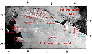
The Abbot Ice Shelf is an ice shelf 250 nautical miles long and 40 nautical miles wide, bordering Eights Coast from Cape Waite to Pfrogner Point in Antarctica. Thurston Island lies along the northern edge of the western half of this ice shelf; other sizable islands lie partly or wholly within this shelf.
Smith Glacier (75°05′S112°00′W is a low-gradient Antarctic glacier, over 160 km long, draining from Toney Mountain in an ENE direction to Amundsen Sea. A northern distributary, Kohler Glacier, drains to Dotson Ice Shelf but the main flow passes to the sea between Bear Peninsula and Mount Murphy, terminating at Crosson Ice Shelf.

The Getz Ice Shelf is an ice shelf over 300 nautical miles long and from 20 to 60 nautical miles wide, bordering the Hobbs Coast and Bakutis Coast of Marie Byrd Land, Antarctica, between the McDonald Heights and Martin Peninsula. Several large islands are partially or wholly embedded in the ice shelf.

The Beethoven Peninsula is a deeply indented, ice-covered peninsula, 60 miles (100 km) long in a northeast–southwest direction and 60 miles (100 km) wide at its broadest part, forming the southwest part of Alexander Island, which lies off the southwestern portion of the Antarctic Peninsula. The south side of the peninsula is supported by the Bach Ice Shelf whilst the north side of the peninsula is supported by the Wilkins Ice Shelf. The Mendelssohn Inlet, the Brahms Inlet and the Verdi Inlet apparently intrude into it. The Bach Ice Shelf, Rossini Point and Berlioz Point are some distance away, on the Ronne Entrance from the Southern Ocean. Beethoven Peninsula is one of the eight peninsulas of Alexander Island.

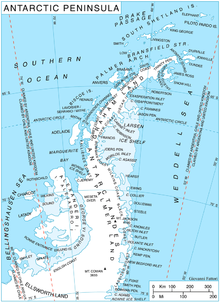
George VI Sound or Canal Jorge VI or Canal Presidente Sarmiento or Canal Seaver or King George VI Sound or King George the Sixth Sound is a major bay/fault depression, 300 miles (483 km) long and mainly covered by a permanent ice shelf. It is in the shape of the letter J without any upper bar. It lines the east and south shores of Alexander Island, separating it from the vestigial, quite small, Wordie Ice Shelf and Palmer Land and the north-facing "English Coast". A quite central point of it is 71°S68°W.

The Amery Ice Shelf is a broad ice shelf in Antarctica at the head of Prydz Bay between the Lars Christensen Coast and Ingrid Christensen Coast. It is part of Mac. Robertson Land. The name "Cape Amery" was applied to a coastal angle mapped on 11 February 1931 by the British Australian New Zealand Antarctic Research Expedition (BANZARE) under Douglas Mawson. He named it for William Bankes Amery, a civil servant who represented the United Kingdom government in Australia (1925–28). The Advisory Committee on Antarctic Names interpreted this feature to be a portion of an ice shelf and, in 1947, applied the name Amery to the whole shelf.
Mawson Peninsula is a high, narrow, ice-covered peninsula on the George V Coast, on the west side of the Slava Ice Shelf, Antarctica, terminating in Cape Hudson. It extends for over 30 nautical miles (56 km) in a northwesterly direction. The peninsula was photographed from the air by U.S. Navy Operation Highjump, 1946–47, and was sketched and photographed by Phillip Law of the Australian National Antarctic Research Expeditions who flew along it to its northern end in February 1959. It was named by the Antarctic Names Committee of Australia for Sir Douglas Mawson.
King Peninsula is an ice-covered peninsula, 100 nautical miles long and 20 nautical miles wide, lying south of Thurston Island and forming the south side of Peacock Sound, Antarctica. It projects from the continental ice sheet and trends west between the Abbot Ice Shelf and Cosgrove Ice Shelf to terminate at the Amundsen Sea.
Minna Bluff is a narrow, bold peninsula, 25 nautical miles long and 3 nautical miles wide, projecting southeast from Mount Discovery into the Ross Ice Shelf, Antarctica. It was discovered by the British National Antarctic Expedition (1901-04) which named it for Minna, the wife of Sir Clements Markham, the "father" of the expedition. It culminates in a south-pointing hook feature, and is the subject of research into Antarctic cryosphere history, funded by the National Science Foundation, Office of Polar Programs.
Bryan Coast is that portion of the coast of Antarctica along the south shore of the Bellingshausen Sea between Pfrogner Point and the northern tip of the Rydberg Peninsula. To the west is Eights Coast, and to the east is English Coast.
Condor Peninsula is a mountainous, ice-covered peninsula, 30 nautical miles long and 10 to 15 nautical miles wide, between Odom Inlet and Hilton Inlet on the east coast of Palmer Land, Antarctica.
Neptune Glacier is a glacier on the east coast of Alexander Island, Antarctica, 12 nautical miles (22 km) long and 4 nautical miles (7 km) wide, flowing east into George VI Sound and the George VI Ice Shelf to the south of Triton Point. Although Neptune Glacier is not located within the mountain range Planet Heights, the glaciers name derives from the mountain range along with many other nearby glaciers named after planets of the Solar System. There are also other nearby landforms named in association with these glaciers. The glacier was first sighted from the air by Lincoln Ellsworth on November 23, 1935, and roughly mapped from photos obtained on that flight by W.L.G. Joerg. The mouth of the glacier was positioned in 1936 by the British Graham Land Expedition (BGLE). Named by the United Kingdom Antarctic Place-Names Committee (UK-APC) for the planet Neptune following a Falkland Islands Dependencies Survey (FIDS) survey in 1949. The head of the glacier was mapped from air photos taken by the Ronne Antarctic Research Expedition (RARE), 1947–48, by Searle of the FIDS in 1960.

Nicholson Peninsula is a broad ice-covered peninsula about 15 nautical miles (28 km) long, between Couzens Bay and Matterson Inlet on the Shackleton Coast on the west side of the Ross Ice Shelf, Antarctica.
Kvinge Peninsula is a snow-covered peninsula at the north side of Palmer Inlet terminating in Cape Bryant, on the east coast of Palmer Land, Antarctica.
Monteverdi Peninsula is a large ice-covered peninsula lying between the Bach Ice Shelf and George VI Sound, forming the southernmost extremity of Alexander Island, Antarctica. The southern side of the feature was first seen and charted by Finn Ronne and Carl Eklund of the United States Antarctic Service, 1939–41, who traversed the entire length of George VI Sound. The peninsula was mapped from trimetrogon air photography taken by the Ronne Antarctic Research Expedition in 1947–48, and from survey by the Falkland Islands Dependencies Survey, 1948–50. It was named by the UK Antarctic Place-Names Committee after Italian composer Claudio Monteverdi.

Rymill Coast is that portion of the west coast of Antarctic Peninsula between Cape Jeremy and Buttress Nunataks. It runs northward from English Coast and east of Alexander Island across George VI Sound, encompassing the Batterbee Mountains. It is joined in the north by Fallieres Coast, which runs along Marguerite Bay. It was named by the United Kingdom Antarctic Place-Names Committee (UK-APC) in 1985 after John Riddoch Rymill (1905–68), Australian leader of the BGLE, 1934–37.

The Lassiter Coast is the portion of the east coast of the Antarctic Peninsula that extends from Cape Mackintosh to Cape Adams. The northern portion of this coast was discovered and photographed from the air by the United States Antarctic Service in 1940. During 1947 the entire extent of the coast was photographed from the air by the Ronne Antarctic Research Expedition (RARE) under Finn Ronne, who in conjunction with the Falkland Islands Dependencies Survey charted it from the ground.