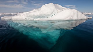
An iceberg is a piece of freshwater ice more than 15 m long that has broken off a glacier or an ice shelf and is floating freely in open (salt) water. Smaller chunks of floating glacially derived ice are called "growlers" or "bergy bits". Much of an iceberg is below the water's surface, which led to the expression "tip of the iceberg" to illustrate a small part of a larger unseen issue. Icebergs are considered a serious maritime hazard.

Jökulsárlón is a large glacial lake in southern part of Vatnajökull National Park, Iceland. Situated at the head of the Breiðamerkurjökull glacier, it developed into a lake after the glacier started receding from the edge of the Atlantic Ocean. The lake has grown since then at varying rates because of melting of the glaciers. The glacial front is now about 8 km (5.0 mi) away from the ocean's edge and the lake covers an area of about 18 km2 (6.9 sq mi). In 2009 it was reported to be the deepest lake in Iceland, at over 284 m (932 ft), as glacial retreat extended its boundaries. The size of the lake has increased fourfold since the 1970s.

The Brunt Ice Shelf borders the Antarctic coast of Coats Land between Dawson-Lambton Glacier and Stancomb-Wills Glacier Tongue. It was named by the UK Antarctic Place-names Committee after David Brunt, British meteorologist, Physical Secretary of the Royal Society, 1948–57, who was responsible for the initiation of the Royal Society Expedition to this ice shelf in 1955.

Iceberg B-15 was the largest recorded iceberg by area. It measured around 295 by 37 kilometres, with a surface area of 11,000 square kilometres, about the size of the island of Jamaica. Calved from the Ross Ice Shelf of Antarctica in March 2000, Iceberg B-15 broke up into smaller icebergs, the largest of which was named Iceberg B-15-A. In 2003, B-15A drifted away from Ross Island into the Ross Sea and headed north, eventually breaking up into several smaller icebergs in October 2005. In 2018, a large piece of the original iceberg was steadily moving northward, located between the Falkland Islands and South Georgia Island. As of August 2023, the U.S. National Ice Center (USNIC) still lists one extant piece of B-15 that meets the minimum threshold for tracking. This iceberg, B-15AB, measures 20 km × 7 km ; it is currently grounded off the coast of Antarctica in the western sector of the Amery region.

The Drygalski Ice Tongue, Drygalski Barrier, or Drygalski Glacier Tongue is a glacier in Antarctica, on the Scott Coast, in the northern McMurdo Sound of Ross Dependency, 240 kilometres (150 mi) north of Ross Island. The Drygalski Ice Tongue is stable by the standards of Antarctica's icefloes, and stretches 70 kilometres (43 mi) out to sea from the David Glacier, reaching the sea from a valley in the Prince Albert Mountains of Victoria Land. The Drygalski Ice Tongue ranges from 14 to 24 kilometres wide.

Mertz Glacier is a heavily crevassed glacier in George V Coast of East Antarctica. It is the source of a glacial prominence that historically has extended northward into the Southern Ocean, the Mertz Glacial Tongue. It is named in honor of the Swiss explorer Xavier Mertz.

Thwaites Glacier is an unusually broad and vast Antarctic glacier located east of Mount Murphy, on the Walgreen Coast of Marie Byrd Land. It was initially sighted by polar researchers in 1940, mapped in 1959–1966 and officially named in 1967, after the late American glaciologist Fredrik T. Thwaites. The glacier flows into Pine Island Bay, part of the Amundsen Sea, at surface speeds which exceed 2 kilometres (1.2 mi) per year near its grounding line. Its fastest-flowing grounded ice is centered between 50 and 100 kilometres east of Mount Murphy. Like many other parts of the cryosphere, it has been adversely affected by climate change, and provides one of the more notable examples of the retreat of glaciers since 1850.

An ice tongue exists when there is a narrow floating part of a glacier that extends out into a body of water beyond the glacier's lowest contact with the Earth's crust. An ice tongue forms when a glacier that is confined by a valley moves very rapidly out into a lake or ocean, relative to other ice along the coastline. When such ice surges past adjacent coastal ice, the boundary experiences physical forces described as "shearing".

Totten Glacier is a large glacier draining a major portion of the East Antarctic Ice Sheet, through the Budd Coast of Wilkes Land in the Australian Antarctic Territory. The catchment drained by the glacier is estimated at 538,000 km2 (208,000 sq mi), extending approximately 1,100 km (680 mi) into the interior and holds the potential to raise sea level by at least 3.5 m (11 ft). Totten drains northeastward from the continental ice but turns northwestward at the coast where it terminates in a prominent tongue close east of Cape Waldron. It was first delineated from aerial photographs taken by USN Operation Highjump (1946–47), and named by Advisory Committee on Antarctic Names (US-ACAN) for George M. Totten, midshipman on USS Vincennes of the United States Exploring Expedition (1838–42), who assisted Lieutenant Charles Wilkes with correction of the survey data obtained by the expedition.

The Erebus Ice Tongue is a mountain outlet glacier and the seaward extension of Erebus Glacier from Ross Island. It projects 11 kilometres (6.8 mi) into McMurdo Sound from the Ross Island coastline near Cape Evans, Antarctica. The glacier tongue varies in thickness from 50 metres (160 ft) at the snout to 300 metres (980 ft) at the point where it is grounded on the shoreline. Explorers from Robert F. Scott's Discovery Expedition (1901–1904) named and charted the ice tongue.
Pobeda Ice Island, original Russian name остров Победы, is an ice island in the Mawson Sea. It is located 160 km (99 mi) off the coast of Queen Mary Land, East Antarctica. This island, which exists periodically, is formed by the running aground of a tabular iceberg.
Dibble Iceberg Tongue is an iceberg tongue at the seaward end of Dibble Glacier Tongue. The names Dibble Glacier and Dibble Glacier Tongue were applied by the Advisory Committee on Antarctic Names (US-ACAN) in 1955, concurrent with G.D. Blodgett's delineation of the features from aerial photographs taken by U.S. Navy Operation Highjump (1946–47). The offshore segment of these two related features was photographed by the Australian National Antarctic Research Expeditions in 1956 and 1959, and the Antarctic Names Committee of Australia subsequently recommended that it be named Dibble Iceberg Tongue. US-ACAN has approved the latter name only for the portion lying seaward of Dibble Glacier Tongue.
Dibble Glacier Tongue is a large glacier tongue extending seaward from Dibble Glacier in Wilkes Land, Antarctica. The seaward end of the glacier tongue is named Dibble Iceberg Tongue. It was delineated from air photos taken by U.S. Navy Operation Highjump (1946–47), and was named by the Advisory Committee on Antarctic Names for Jonas Dibble and the unsung crew members of the United States Exploring Expedition squadron under Lieutenant Charles Wilkes, 1838–42.

Dibble Glacier in Antarctica is a prominent channel glacier flowing from the continental ice and terminating in a prominent tongue at the east side of Davis Bay. It was delineated from air photos taken by U.S. Navy Operation Highjump (1946–47), and named by the Advisory Committee on Antarctic Names for Jonas Dibble, ship's carpenter on the sloop Peacock of the United States Exploring Expedition (1838–42) under Charles Wilkes. Dibble is credited with leaving his sick bed and working 24 hours without relief with other carpenters to repair a broken rudder on the Peacock, when the ship was partially crushed in an ice bay in 151°19′E and forced to retire northward.

Petermann Glacier is a large glacier located in North-West Greenland to the east of Nares Strait. It connects the Greenland ice sheet to the Arctic Ocean at 81°10' north latitude, near Hans Island.

Nioghalvfjerdsbrae, sometimes referred to as "79 N Glacier", is a large glacier located in King Frederick VIII Land, northeastern Greenland. It drains an area of 103,314 km2 (39,890 sq mi) of the Greenland Ice Sheet with a flux of 14.3 km3 (3.4 cu mi) per year, as measured for 1996. The glacier has two calving fronts where the glacier meets the ocean, separated by Hovgaard Island. In July 2020, the northern offshoot, the Spalte Glacier broke away from Nioghalvfjerdsbrae and completely disintegrated.
Blodgett Iceberg Tongue is a large iceberg tongue that extends seaward from the vicinity of Cape Morse and Cape Carr on the east side of Porpoise Bay. It was named by the Advisory Committee on Antarctic Names for Gardner D. Blodgett, Office of Geography, Department of Interior, who, in 1955, prepared a sketch map of the coastal features of Antarctica between 84°E and 144°E from U.S. Navy Operation Highjump (1946–47) aerial photographs. Since the iceberg tongue was partially delineated for the first time on the 1955 sketch map by Blodgett, use of his name for it is considered appropriate.
Colvocoresses Bay is a bay formed by the right angle of the Budd Coast at Williamson Glacier. The bay is over 30 nautical miles (56 km) wide at the entrance and is occupied by glacier tongues and icebergs from Williamson Glacier and Whittle Glacier. It was delineated by G.D. Blodgett (1955) from aerial photographs taken by U.S. Navy Operation Highjump (1946–47), and named by the Advisory Committee on Antarctic Names for George Colvocoresses, midshipman on the sloop Vincennes during the United States Exploring Expedition (1838–42) under Charles Wilkes. Colvocoresses, later promoted to captain, U.S. Navy, published (1852–55) his own account of the voyage in Four Years in the Government Exploring Expedition Commanded by Captain Wilkes.

Breiðamerkurjökull is an outlet glacier of the larger glacier of Vatnajökull and a piedmont glacier in the southern part of Vatnajökull National Park, Iceland. Emerging as a tongue of the Vatnajökull, it ends in a small lagoon, known as Jökulsárlón. Over time, it has gradually been breaking down.
