List of glaciers of the Palmer Archipelago and Graham Land

Last updated

Palmer archipelago Palmer archipelago, Antarctica.jpg
Palmer archipelago
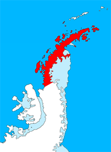
Graham Land GrahamLandstubmap.png
Graham Land

Following is a list of glaciers of the Palmer Archipelago and Graham Land in Antarctica. This list may not reflect recently named glaciers in the Palmer Archipelago and Graham Land.

Contents

Palmer Archipelago

Adelaide Island

Antarctic Peninsula

James Ross Island

Trinity Peninsula

Related Research Articles

<span class="mw-page-title-main">Antarctic Peninsula</span> Peninsula located in northern Antarctica

The Antarctic Peninsula, known as O'Higgins Land in Chile and Tierra de San Martín in Argentina, and originally as Graham Land in the United Kingdom and the Palmer Peninsula in the United States, is the northernmost part of mainland Antarctica.

<span class="mw-page-title-main">Graham Land</span> Section of the Antarctic Peninsula and surrounding islands

Graham Land is the portion of the Antarctic Peninsula that lies north of a line joining Cape Jeremy and Cape Agassiz. This description of Graham Land is consistent with the 1964 agreement between the British Antarctic Place-names Committee and the US Advisory Committee on Antarctic Names, in which the name "Antarctic Peninsula" was approved for the major peninsula of Antarctica, and the names Graham Land and Palmer Land for the northern and southern portions, respectively. The line dividing them is roughly 69 degrees south.

<span class="mw-page-title-main">Palmer Land</span> Geographic region in Antarctica

Palmer Land is the portion of the Antarctic Peninsula, Antarctica that lies south of a line joining Cape Jeremy and Cape Agassiz. This application of Palmer Land is consistent with the 1964 agreement between the Advisory Committee on Antarctic Names and the UK Antarctic Place-Names Committee, in which the name Antarctic Peninsula was approved for the major peninsula of Antarctica, and the names Graham Land and Palmer Land for the northern and southern portions, respectively. The line dividing them is roughly 69° S.

Bertrand Ice Piedmont is an ice piedmont about 20 kilometres (11 nmi) long and from 6 to 9 kilometres wide, lying between Rymill Bay and Mikkelsen Bay on the Fallières Coast of Graham Land.

<span class="mw-page-title-main">Graham Bell Island</span> Island in Franz Josef archipelago

Graham Bell Island is an island in the Franz Josef Archipelago in the Arctic Ocean, and is administratively part of Arkhangelsk Oblast, Russia.

<span class="mw-page-title-main">Swithinbank Glacier</span> Glacier in Graham Land, Antarctica

Swithinbank Glacier is a glacier on the west side of Hemimont Plateau flowing north to the southeast corner of Square Bay, in Graham Land. Mapped by Falkland Islands Dependencies Survey (FIDS) from surveys and air photos, 1946–59. Named by United Kingdom Antarctic Place-Names Committee (UK-APC) for Charles Swithinbank, British glaciologist, a participant in several British, New Zealand and American expeditions to Antarctica, 1949–62.

<span class="mw-page-title-main">Jorum Glacier</span> Glacier in Antarctica

Jorum Glacier is a glacier draining the southeast slopes of Forbidden Plateau, and lowing east into Exasperation Inlet, just north of Caution Point, on the east coast of Graham Land, Antarctica. It was surveyed by the Falkland Islands Dependencies Survey in 1947 and 1955. The UK Antarctic Place-Names Committee name alludes to the punchbowl shape of the head of the glacier, a "jorum" being a large drinking bowl used for punch.

Toynbee Glacier is a glacier situated in the northeast portion of Alexander Island, Antarctica, extending 17 nautical miles (31 km) long and 5 nautical miles (9 km) wide, lying between Mount Huckle, Mount Spivey and Mount Stephenson of the northern portion of the Douglas Range on the west and Mount Tyrrell and Mount Tilley on the east. It flows north from the east face of Mount Stephenson into the George VI Ice Shelf that occupies George VI Sound. The glacier was first photographed from the air in 1937 by the British Graham Land Expedition under Rymill. Surveyed in 1948 by the Falkland Islands Dependencies Survey and named for Patrick A. Toynbee, FIDS air pilot at Stonington Island in 1948 and 1949.

Pluto Glacier is a glacier on the east coast of Alexander Island, Antarctica, 10 nautical miles (18 km) long and 4 nautical miles (7 km) wide, which flows east into George VI Sound to the north of Succession Cliffs. Although Pluto Glacier is not located within nearby Planet Heights, the glacier was named in association with the mountain range along with many other nearby glaciers that are named after planets of the Solar System. The glacier was first photographed from the air on November 23, 1935, by Lincoln Ellsworth and mapped from these photos by W.L.G. Joerg. Roughly surveyed in 1936 by the British Graham Land Expedition (BGLE). Named by the United Kingdom Antarctic Place-Names Committee (UK-APC) for Pluto, then considered the ninth planet of the Solar System, following Falkland Islands Dependencies Survey (FIDS) surveys in 1948 and 1949.

<span class="mw-page-title-main">Evans Glacier (Graham Land)</span> Glacier in Antarctica

Evans Glacier is a gently-sloping glacier 15 nautical miles (28 km) long and 4 nautical miles (7 km) wide, draining the southeast slopes of Travnik Buttress eastwards between Rugate Ridge and Poibrene Heights to flow into Vaughan Inlet on the east coast of Graham Land, Antarctica. It was discovered by Sir Hubert Wilkins in an aerial flight, December 20, 1928, and named "Evans Inlet" by him for E.S. Evans of Detroit. A further survey by the Falkland Islands Dependencies Survey in 1955 reported that this low-lying area is not an inlet, but is formed by the lower reaches of Hektoria Glacier and the feature now described.

Talbot Glacier is a glacier flowing into Etienne Fjord, Flandres Bay, on the west coast of Graham Land. First charted by the Belgian Antarctic Expedition under Gerlache, 1897–99. Named by the United Kingdom Antarctic Place-Names Committee (UK-APC) in 1960 for William H.F. Talbot (1800–77), English inventor of the first practical photographic process on paper, perfected and called calotype in 1839–41.

Specimen Nunatak is a small but distinctive rock pinnacle that rises above the ice of Swithinbank Glacier about 4 nautical miles (7 km) south of the glacier terminus, in Graham Land. The feature was visited on February 9, 1941 by Herbert G. Dorsey and Joseph D. Healy of the United States Antarctic Service (USAS), 1939–41, who gave the name because the pinnacle was a good example of a nunatak projecting above a broad ice field.

Remus Glacier is a glacier, 8 nautical miles (15 km) long, which flows from the north slopes of Mount Lupa northwestward along the northeast side of the Blackwall Mountains into Providence Cove, Neny Fjord, on the west coast of Graham Land. The lower reaches of the glacier were first roughly surveyed in 1936 by the British Graham Land Expedition (BGLE) under Rymill. Resurveyed in 1948-49 by the Falkland Islands Dependencies Survey (FIDS), who so named it for its association with Romulus Glacier, whose head lies near the head of this glacier.

Vallot Glacier is a glacier flowing northwest to Laubeuf Fjord close south of Lewis Peaks, on Arrowsmith Peninsula in Graham Land. It was mapped by the Falkland Islands Dependencies Survey (FIDS) from surveys and air photos, 1948–59, and was named by the United Kingdom Antarctic Place-Names Committee (UK-APC) for Joseph Vallot, a French naturalist and glaciologist who first measured the surface velocity of a glacier over a long period, in Switzerland, 1891–99.

<span class="mw-page-title-main">Kom Glacier</span> Glacier in Graham Land, Antarctica

Kom Glacier is the 10 km long and 8 km wide glacier on the west side of Hemimont Plateau, Fallières Coast in Graham Land, Antarctica. It is situated south of Forbes Glacier and north of Swithinbank Glacier, drains westwards between Mercury Ridge and Zhefarovich Crag, and flows into Square Bay next north of Swithinbank Glacier.