Jorum Glacier

Last updated
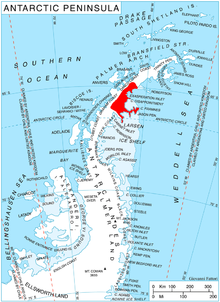
Location of Oscar II Coast on Antarctic Peninsula. Ant-pen-map-Oscar-II.PNG
Location of Oscar II Coast on Antarctic Peninsula.

Jorum Glacier ( 65°14′S62°3′W / 65.233°S 62.050°W / -65.233; -62.050 ) is a glacier draining the southeast slopes of Forbidden Plateau, and lowing east into Exasperation Inlet, just north of Caution Point, on the east coast of Graham Land, Antarctica. It was surveyed by the Falkland Islands Dependencies Survey in 1947 and 1955. The UK Antarctic Place-Names Committee name alludes to the punchbowl shape of the head of the glacier, a "jorum" being a large drinking bowl used for punch. [1]

Contents

Further reading

Related Research Articles

<span class="mw-page-title-main">George VI Sound</span> Body of water in Palmer Land, Antarctica

George VI Sound or Canal Jorge VI or Canal Presidente Sarmiento or Canal Seaver or King George VI Sound or King George the Sixth Sound is a major bay/fault depression, 300 miles (483 km) long and mainly covered by a permanent ice shelf. It is in the shape of the letter J without any upper bar. It lines the east and south shores of Alexander Island, separating it from the vestigial, quite small, Wordie Ice Shelf and Palmer Land and the north-facing "English Coast". A quite central point of it is 71°S68°W.

Zykov Glacier is a valley glacier about 25 nautical miles long in the Anare Mountains of Victoria Land, Antarctica. It flows northwest and reaches the coast between Cape Williams and Cooper Bluffs. It was photographed by the Soviet Antarctic Expedition (SovAE) in 1958 and named for student navigator Ye. Zykov, who died in Antarctica, Feb. 3, 1957.

<span class="mw-page-title-main">Liv Glacier</span> Glacier in Antarctica

Liv Glacier is a steep valley glacier, 40 nautical miles long, emerging from the Antarctic Plateau just southeast of Barnum Peak and draining north through the Queen Maud Mountains to enter Ross Ice Shelf between Mayer Crags and Duncan Mountains. It was discovered in 1911 by Roald Amundsen, who named it for the daughter of Fridtjof Nansen.

The Mulock Glacier is a large, heavily crevassed glacier which flows into the Ross Ice Shelf 40 kilometers south of the Skelton Glacier in the Ross Dependency, Antarctica.

<span class="mw-page-title-main">Crane Glacier</span> Glacier in the Aristotle Mountains of the Antarctic Peninsula

Crane Glacier is a narrow glacier which flows 30 miles (50 km) in an east-northeasterly direction along the northwest side of Aristotle Mountains to enter Spillane Fjord south of Devetaki Peak, on the east coast of the Antarctic Peninsula. Sir Hubert Wilkins photographed this feature from the air in 1928 and gave it the name "Crane Channel", after C.K. Crane of Los Angeles, reporting that it appeared to be a channel cutting in an east-west direction across the peninsula. The name was altered to "Crane Inlet" following explorations along the west coast of the peninsula in 1936 by the British Graham Land Expedition, which proved that no through channel from the east coast existed as indicated by Wilkins. Comparison of Wilkins' photograph of this feature with those taken in 1947 by the Falklands Islands Dependencies Survey shows that Wilkins' "Crane Channel" is this glacier, although it lies about 75 miles (120 km) northeast of the position originally reported by Wilkins.

<span class="mw-page-title-main">Flask Glacier</span> Glacier in Antarctica

Flask Glacier, is a gently-sloping glacier, 25 nautical miles long, flowing east from Bruce Plateau to enter Scar Inlet between Daggoo Peak and Spouter Peak in Graham Land, Antarctica. The lower reaches of this glacier were surveyed and photographed by the Falklands Islands Dependencies Survey (FIDS) in 1947. The entire glacier was photographed by the Falkland Islands and Dependencies Aerial Survey Expedition in 1955–56, and mapped by the FIDS in 1957. It was named by the UK Antarctic Place-names Committee after the third mate on the Pequod in Herman Melville's Moby-Dick; or, The White Whale.

Radok Lake is a meltwater lake about four miles (6.4 km) long and marked by a slender glacier tongue feeding into it from the west, lying three miles (4.8 km) south-west of Beaver Lake and 15 miles (24 km) south-east of the Aramis Range, Prince Charles Mountains. It was plotted by Australian National Antarctic Research Expeditions (ANARE) from air photos taken by the RAAF Antarctic Flight in 1956. The lake was named for Uwe Radok, Reader (head) of Meteorology Department at the University of Melbourne, who greatly assisted Australian National Antarctic Research Expeditions (ANARE)'s glaciological program. With a depth of 362 metres (1,188 ft), Radok Lake is the deepest known surface lake on the Antarctic continent and the only known freshwater lake to host a floating ice tongue glacier. It is drained by three-mile-long (4.8 km) Pagodroma Gorge in to Beaver Lake. Radok Lake is an isothermal and non-stratified Lake, i.e. homogeneous water body.

Mount Bistre is a mountain on the north side of Evans Glacier on the east side of Graham Land. It was surveyed by the Falkland Islands Dependencies Survey (FIDS) in 1947, and again in 1955. The name, by the United Kingdom Antarctic Place-Names Committee (UK-APC), is descriptive of the dark brown color of the steep east and south rock faces of the feature.

The Carey Range is a mountain range, about 35 nautical miles long and 5 nautical miles wide with peaks rising to 1,700 metres (5,600 ft), between Mosby Glacier and Fenton Glacier in southeast Palmer Land, Antarctica.

<span class="mw-page-title-main">Wiggins Glacier</span> Glacier in Graham Land, Antarctica

Wiggins Glacier is a 10 nautical miles (18 km) long glacier on Kyiv Peninsula in Antarctica, flowing from Bruce Plateau to the west coast of Graham Land just south of Blanchard Ridge. Charted by the French Antarctic Expedition, 1908–10, under Charcot, and named Glacier du Milieu. Feeling that a more distinctive name was needed, the United Kingdom Antarctic Place-Names Committee (UK-APC) in 1959 renamed the glacier for W.D.C. Wiggins, then Deputy Director of Overseas Surveys.

Coulter Heights are snow-covered heights that rise between Strauss Glacier and Frostman Glacier near the coast of Marie Byrd Land, Antarctica. The rock outcrops of Kuberry Rocks, Matikonis Peak and Lambert Nunatak protrude above the snow surface of the heights.

<span class="mw-page-title-main">Punchbowl Glacier</span> Glacier in Antarctica

Punchbowl Glacier is a glacier that flows southwards between Poibrene Heights and Metlichina Ridge, and enters the north end of Exasperation Inlet, north of Jorum Glacier, on the east side of Graham Land, Antarctica.

Perry Range is a narrow range of mountains, 6 nautical miles long, separating the lower ends of Venzke Glacier and Berry Glacier where they enter Getz Ice Shelf, on the coast of Marie Byrd Land, Antarctica.

The Phillips Mountains are a range of mountains on the north side of Balchen Glacier and Block Bay in the Ford Ranges, Marie Byrd Land, Antarctica.

<span class="mw-page-title-main">Evans Glacier (Graham Land)</span> Glacier in Antarctica

Evans Glacier is a gently-sloping glacier 15 nautical miles (28 km) long and 4 nautical miles (7 km) wide, draining the southeast slopes of Travnik Buttress eastwards between Rugate Ridge and Poibrene Heights to flow into Vaughan Inlet on the east coast of Graham Land, Antarctica. It was discovered by Sir Hubert Wilkins in an aerial flight, December 20, 1928, and named "Evans Inlet" by him for E.S. Evans of Detroit. A further survey by the Falkland Islands Dependencies Survey in 1955 reported that this low-lying area is not an inlet, but is formed by the lower reaches of Hektoria Glacier and the feature now described.

Fricker Glacier is a glacier, 10 nautical miles (19 km) long, which lies close north of Tindal Bluff and Monnier Point and flows in a northeasterly direction into the southwest side of Mill Inlet, on the east coast of Graham Land, Antarctica. It was charted by the Falkland Islands Dependencies Survey (FIDS) and photographed from the air by the Ronne Antarctic Research Expedition in 1947, and was named by the FIDS for Karl Fricker, a German Antarctic historian.

Metchnikoff Point is a point forming the western extremity of Pasteur Peninsula in northern Brabant Island, in the Palmer Archipelago, Antarctica. It was first charted by the Third French Antarctic Expedition, 1903–05, and named by Jean-Baptiste Charcot for Russian-born zoologist and bacteriologist Élie Metchnikoff, who succeeded Louis Pasteur as the director of the Pasteur Institute in Paris.

The McDonald Heights are broad, mainly snow-covered heights about 35 nautical miles (65 km) long and rising over 1,000 metres (3,300 ft) between Cape Burks and Morris Head on the coast of Marie Byrd Land, Antarctica. The heights are bounded southward by Hull Glacier, Kirkpatrick Glacier and Johnson Glacier.

<span class="mw-page-title-main">Mount Howell</span> Mountain in Ellsworth Land, Antarctica

Mount Howell is a mountain 3 nautical miles (6 km) south-southwest of Mount Borgeson in the Walker Mountains of Thurston Island, Antarctica. It was named by the Advisory Committee on Antarctic Names after Lieutenant Commander John D. Howell, a pilot and airplane commander in the Eastern Group of U.S. Navy Operation Highjump, which obtained aerial photographs of this mountain and coastal areas adjacent to Thurston Island in 1946–47. Commander Howell landed a PBM Mariner seaplane in the open water of eastern Glacier Bight on January 11, 1947 to rescue six survivors of a December 30 Mariner crash on Noville Peninsula.

The Hutton Mountains are a group of mountains in southeast Palmer Land, Antarctica, bounded on the southwest by Johnston Glacier, on the northwest by Squires Glacier, on the north by Swann Glacier, and on the east by Keller Inlet.

References

  1. "Jorum Glacier". Geographic Names Information System . United States Geological Survey, United States Department of the Interior . Retrieved 2013-04-08.

PD-icon.svg This article incorporates public domain material from "Jorum Glacier". Geographic Names Information System . United States Geological Survey.