List of glaciers of Heard Island and McDonald Islands

Last updated

A map of Heard Island and McDonald Islands Heard Island and McDonald Islands map.png
A map of Heard Island and McDonald Islands

Following is a list of glaciers of Heard Island and McDonald Islands in Antarctica. This list may not reflect recently named glaciers in Heard Island and McDonald Islands.

Contents

Context

Heard Island from a boat facing southwest from approximately the Shag Islets Heard Island (cropped).jpg
Heard Island from a boat facing southwest from approximately the Shag Islets
Field party, roped together, explore badly crevassed glacier - Heard Island 1950s Field party, roped together, explore badly crevassed glacier - Heard Island (6433874037).jpg
Field party, roped together, explore badly crevassed glacier - Heard Island 1950s

Heard Island is a volcanic island in the Southern Ocean that is 80% covered in ice. [1] The island is cold and steep, and experiences high levels of snowfall. [2] There are many glaciers, which descend for up to 7 kilometres (4.3 mi) from up to 2,400 metres (7,900 ft) down to sea level. [1] The larger glaciers lose as much as 80% of their volume through calving into the ocean, and they are not particularly sensitive to temperature changes. Melting is a more significant factor in loss of volume for the smaller glaciers. [2]

Spring temperatures in the 1980s were about 1.7 °C (35.1 °F) higher than the average in 1946–54. [2] Comparison of air photographs from 1947 and early 1970 show that glaciers have generally retreated, particularly on the eastern flanks, and that they have narrowed on northern and windward western flanks. [1] The area covered by glaciers had shrunk from 288 square kilometres (111 sq mi) in 1947 to 257 square kilometres (99 sq mi) by 1988. A visit to the island in Spring 2000 showed several glaciers had retreated further, including the Stephenson, Brown and Baudissin glaciers. [2] Other studies have also shown the glaciers are retreating. [3] [4]

Map all coordinates using: OpenStreetMap

List of glaciers

Abbotsmith Glacier

53°06′S73°24′E / 53.100°S 73.400°E / -53.100; 73.400 . A well-defined glacier, 3 nautical miles (5.6 km; 3.5 mi) long, descending from the ice-covered west slopes of Big Ben to the west side of Heard Island between Walsh Bluff and Henderson Bluff. Surveyed in 1948 by the Australian National Antarctic Research Expeditions (ANARE) who named it for John Abbotsmith, engineer with the party. [5]

Allison Glacier

53°04′S73°24′E / 53.067°S 73.400°E / -53.067; 73.400 . An ice stream on Heard Island flowing from Big Ben down to the sea to the south of Cape Gazert. Named after Ian Allison, glaciologist, Australian Antarctic Division, who carried out glaciological studies in this area in 1971 during the French-Australian Expedition. [6]

Baudissin Glacier

53°02′S73°26′E / 53.033°S 73.433°E / -53.033; 73.433 A glacier, 1.5 nautical miles (2.8 km; 1.7 mi) wide, flowing into the west part of Corinthian Bay, 1 nautical mile (1.9 km; 1.2 mi) west of Challenger Glacier, on the north side of Heard Island. The glacier appears to have been first noted by a sketch in the narrative accompanying the scientific reports of the 1874 Challenger work along the north side of the island. The GerAE under Drygalski, 1901-03, portrayed a single large glacier flowing into Corinthian Bay and named it after Admiral Count Friedrich Baudissin, a sponsor of the expedition. In 1948 the ANARE determined that more than one glacier discharges into Corinthian Bay. The Antarctic Names Committee of Australia (ANCA) recommended in 1954 that Baudissin Glacier be adopted for the westernmost and largest of these glaciers. Not: Baudissen Glacier. [7]

Brown Glacier

53°04′S73°39′E / 53.067°S 73.650°E / -53.067; 73.650 . A glacier just south of Round Hill on the east side of Heard Island. Surveyed by ANARE in 1948. Named by ANCA for K.G. Brown, ANARE biologist on Heard Island in 1951. [8] Between 1947 and 2004 the Brown Glacier shrank in area by about 29% from 6.18 square kilometres (2.39 sq mi) to 4.38 square kilometres (1.69 sq mi), with a corresponding reduction in volume. The change appears to be due to increased air temperatures during this period rather than any other factor. [9]

Challenger Glacier

53°02′S73°28′E / 53.033°S 73.467°E / -53.033; 73.467 . A glacier, 0.8 nautical miles (1.5 km; 0.92 mi) wide, flowing into the east part of Corinthian Bay, 1 nautical mile (1.9 km; 1.2 mi) east of Baudissin Glacier, on the north side of Heard Island. The glacier appears to have been first charted by the GerAE under Drygalski, 1901-03, who portrayed a single large glacier flowing into Corinthian Bay. In 1948 the ANARE determined that more than one glacier discharges into Corinthian Bay. The ANARE applied the name Challenger Glacier to the easternmost of these glacier's to commemorate the work of the British Challenger expedition, 1873-76. [10]

Compton Glacier

53°03′S73°37′E / 53.050°S 73.617°E / -53.050; 73.617 . A glacier, 3 nautical miles (5.6 km; 3.5 mi) long, flowing northeast from the lower slopes of Big Ben to the northeast side of Heard Island between Gilchrist Beach and Fairchild Beach. The lower reaches of this glacier were charted and named "Morgan's Iceberg" on an 1860 sketch map compiled by Capt. H.C. Chester, American sealer operating in the area during this period. The feature was surveyed in 1948 by the ANARE, who applied the name Compton Glacier for G.S. Compton, assistant surveyor with the expedition. Not: Morgan's Iceberg. [11]

Deacock Glacier

53°11′S73°31′E / 53.183°S 73.517°E / -53.183; 73.517 . A glacier close west of Lavett Bluff on the south side of Heard Island. Surveyed by ANARE, 1948-63. Named by ANCA for W. Deacock, a member of ANARE on Heard Island in 1963. [12]

Downes Glacier

53°02′S73°31′E / 53.033°S 73.517°E / -53.033; 73.517 . A broad glacier flowing north on both sides of Cape Bidlingmaier to the north coast of Heard Island. Surveyed by ANARE in 1948. Named by ANCA for M.C. Downes, ANARE biologist at Heard Island in 1951 and 1963. [13]

Ealey Glacier

A glacier flowing from Big Ben on Heard Island to the sea between Melbourne Bluff and North Barrier. The glacier terminates in ice cliffs. Named For E.H.M. Ealey, Biologist, 1949 ANARE Heard Island Expedition who crossed the glacier during a biological survey en route to Spit Point. [14]

Fiftyone Glacier

53°11′S73°34′E / 53.183°S 73.567°E / -53.183; 73.567 . A large glacier flowing south between Lavett Bluff and Lambeth Bluff on the south side of Heard Island. Surveyed by ANARE in 1948. Named "The 1951 Glacier" by an ANARE party that made a traverse of Heard Island in 1951. The form Fiftyone Glacier was recommended by ANCA in 1964. [15]

Gotley Glacier

53°10′S73°27′E / 53.167°S 73.450°E / -53.167; 73.450 . A well-defined glacier, 5 nautical miles (9.3 km; 5.8 mi) long, descending from the ice-covered slopes of Big Ben to the southwest side of Heard Island between Cape Arkona and Cape Labuan. Surveyed in 1948 by the ANARE, and named by them for Aubrey V. Gotley, meteorologist and officer-in-charge of the party. [16]

Jacka Glacier

53°00′S73°20′E / 53.000°S 73.333°E / -53.000; 73.333 . A glacier, 0.8 nautical miles (1.5 km; 0.92 mi) long, flowing northeast from Hayter Peak and terminating in icefalls opposite Vanhoffen Bluff on the north side of Heard Island. The glacier appears to be roughly charted on an 1860 sketch map compiled by Capt. H.C. Chester, American sealer operating in the area during this period. It was surveyed in 1948 by the ANARE, and named by them for Fred J. Jacka, expedition physicist. [17]

Lied Glacier

53°09′S73°26′E / 53.150°S 73.433°E / -53.150; 73.433 . A glacier close north of Cape Arkona on the southwest side of Heard Island. Surveyed by ANARE in 1948. Named by ANCA for N.T. Lied, radio operator and weather observer with ANARE on Heard Island in the years 1951 and 1963, respectively. [18]

Schmidt Glacier

53°03′S73°24′E / 53.050°S 73.400°E / -53.050; 73.400 . A glacier, 0.7 nautical miles (1.3 km; 0.81 mi) long, flowing west from Baudissin Glacier between Mount Drygalski and North West Cornice, on the west side of Heard Island. The feature was roughly charted in 1902 by the German Antarctic Expedition (GerAE) under Erich von Drygalski. He named it for Dr. J. Schmidt of the Royal Prussian Ministry, who assisted in obtaining government support for the expedition. [19]

Stephenson Glacier

53°06′S73°42′E / 53.100°S 73.700°E / -53.100; 73.700 . A glacier close west of Dovers Moraine on the east side of Heard Island. Surveyed by ANARE in 1948. Named by ANCA for P.J. Stephenson, ANARE geologist on Heard Island in 1963. [20]

Vahsel Glacier

53°04′S73°23′E / 53.067°S 73.383°E / -53.067; 73.383 A glacier draining west into South West Bay on the west side of Heard Island. The feature was charted in 1902 by the GerAE under Drygalski. He named it for Richard Vahsel, an officer on the Gauss and a member of the party that made geological investigations near Atlas Cove. [21]

Winston Glacier

53°09′S73°38′E / 53.150°S 73.633°E / -53.150; 73.633 . A glacier flowing to Winston Lagoon on the southeast side of Heard Island. Surveyed by ANARE in 1948. Named by ANCA in 1964 in association with nearby Winston Lagoon. [22]

Related Research Articles

Lillie Glacier is a large glacier in Antarctica, about 100 nautical miles long and 10 nautical miles wide. It lies between the Bowers Mountains on the west and the Concord Mountains and Anare Mountains on the east, flowing to Ob' Bay on the coast and forming the Lillie Glacier Tongue.

<span class="mw-page-title-main">Lambert Glacier</span> Major glacier in East Antarctica

Lambert Glacier is a major glacier in East Antarctica. At about 80 km (50 mi) wide, over 400 km (250 mi) long, and about 2,500 m (8,200 ft) deep, it is the world's largest glacier. It drains 8% of the Antarctic ice sheet to the east and south of the Prince Charles Mountains and flows northward to the Amery Ice Shelf. It flows in part of Lambert Graben and exits the continent at Prydz Bay.

Fisher Glacier is a glacier in Mac. Robertson Land, Antarctica. It is a major tributary of the Lambert Glacier. The glacier is unusual in periodically surging.

<span class="mw-page-title-main">Prince Charles Mountains</span> Mountain range in Antarctica

The Prince Charles Mountains are a major group of mountains in Mac. Robertson Land in Antarctica, including the Athos Range, the Porthos Range, and the Aramis Range. The highest peak is Mount Menzies, with a height of 3,228 m (10,591 ft). Other prominent peaks are Mount Izabelle and Mount Stinear. These mountains, together with other scattered peaks, form an arc about 420 km (260 mi) long, extending from the vicinity of Mount Starlight in the north to Goodspeed Nunataks in the south.

The Lazarev Mountains are a chain of mountains in Antarctica. They extend along the west side of Matusevich Glacier southward of Eld Peak, and are about 25 nautical miles long.

Wilson Hills is a group of scattered hills, nunataks and ridges that extend northwest–southeast about 70 nautical miles between Matusevich Glacier and Pryor Glacier in Antarctica.

<span class="mw-page-title-main">David Glacier</span> Glacier in Antarctica

The David Glacier is a glacier over 60 nautical miles long, flowing east from the polar plateau through the Prince Albert Mountains to the coast of Victoria Land, Antarctica. It enters Ross Sea between Cape Philippi and Cape Reynolds to form the floating Drygalski Ice Tongue. It is the most imposing outlet glacier in Victoria Land. It is fed by two main flows which drain an area larger than 200,000 square kilometres, with an estimated ice discharge rate of 7.8 +/- 0.7 km³/year. The David Glacier was discovered by Ernest Shackleton's "Northern Party," in November 1908, under the leadership of Prof. T.W. Edgeworth David, of Sydney University, for whom the feature was named.

The Mariner Glacier is a major glacier over 60 nautical miles long, descending southeast from the plateau of Victoria Land, Antarctica, between Mountaineer Range and Malta Plateau, and terminating at Lady Newnes Bay, Ross Sea, where it forms the floating Mariner Glacier Tongue.

<span class="mw-page-title-main">Baudissin Glacier</span> Glacier in Antarctica

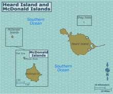
Baudissin Glacier is a tidewater glacier on the north side of Heard Island. in the southern Indian Ocean. Located 1 nautical mile (1.9 km) west of Challenger Glacier, Baudissin Glacier is 1.5 nautical miles (2.8 km) wide and flows into the western part of Corinthian Bay. The terminus of Baudissin Glacier is located at the western side of Corinthian Bay, at Sealers Cove. To the east of Baudissin Glacier is Challenger Glacier, whose terminus is located at the eastern side of Corinthian Bay, close west to Saddle Point. To the south of Baudissin Glacier is Schmidt Glacier, and to the northwest is Atlas Cove. Kildalkey Head is west of Schmidt Glacier. To the south of Schmidt Glacier is Vahsel Glacier, whose terminus is at South West Bay, between Erratic Point and Cape Gazert. Immediately south of Vahsel Glacier is Allison Glacier. Click here to see a map of Baudissin Glacier and the northwestern coast of Heard Island.

<span class="mw-page-title-main">Brown Glacier</span>

Brown Glacier is a glacier just south of Round Hill on the east side of Heard Island in the southern Indian Ocean. Its terminus is at Brown Lagoon. To the northwest of Brown Glacier is Compton Glacier, whose terminus is located at Compton Lagoon, between Gilchrist Beach and Fairchild Beach. To the southeast of Brown Glacier is Stephenson Glacier, whose terminus is located between Dovers Moraine and Stephenson Lagoon.

<span class="mw-page-title-main">Challenger Glacier</span> Glacier in Antarctica

Challenger Glacier is a tidewater glacier on the north side of Heard Island in the southern Indian Ocean. Located 1 nautical mile (2 km) east of Baudissin Glacier, Challenger Glacier is 0.8 nautical miles (1.5 km) wide and flows into the eastern side of Corinthian Bay, close west to Saddle Point. To the east of Challenger Glacier is Downes Glacier, whose terminus is located at Mechanics Bay, between Saddle Point and Cape Bidlingmaier. To the west of Challenger Glacier is Baudissin Glacier, whose terminus is located at the western side of Corinthian Bay, near Sealers Cove.

<span class="mw-page-title-main">Deacock Glacier</span>

Deacock Glacier is a glacier close west of Lavett Bluff on the south side of Heard Island in the southern Indian Ocean. Its terminus is between Cape Labuan and Long Beach. To the east of Deacock Glacier is Fiftyone Glacier, whose terminus is located between Lavett Bluff and Lambeth Bluff. To the west of Deacock Glacier is Gotley Glacier, whose terminus is located between Cape Arkona and Cape Labuan.

<span class="mw-page-title-main">Downes Glacier</span>

Downes Glacier is a broad tidewater glacier on the north side of Heard Island in the southern Indian Ocean. It flows north on both sides of Cape Bidlingmaier to the north coast of Heard Island. To the east of Downes Glacier is Ealey Glacier, whose terminus is located close southeast of Cape Bidlingmaier. To the west of Downes Glacier is Challenger Glacier, whose terminus is located at the eastern side of Corinthian Bay, close west to Saddle Point. Saddle Point separates Downes Glacier from Challenger Glacier.

<span class="mw-page-title-main">Schmidt Glacier (Heard Island and McDonald Islands)</span>

Schmidt Glacier is a glacier, 0.7 nautical miles (1.3 km) long, flowing west from Baudissin Glacier between Mount Drygalski and North West Cornice, on the west side of Heard Island in the southern Indian Ocean. To the north of Schmidt Glacier is Baudissin Glacier, whose terminus is located at the western side of Corinthian Bay, near Sealers Cove. Kildalkey Head is west of Schmidt Glacier. To the south of Schmidt Glacier is Vahsel Glacier, whose terminus is at South West Bay, between Erratic Point and Cape Gazert. Immediately south of Vahsel Glacier is Allison Glacier. Click here to see a map of Schmidt Glacier and the northwestern coast of Heard Island.

Walsh Bluff is a rock bluff close north of the mouth of Abbotsmith Glacier on the west side of Heard Island. Surveyed by ANARE in 1948. Named by Antarctic Names Committee of Australia (ANCA) for J.E. Walsh, ANARE weather observer on Heard Island in 1950 and 1954; dog attendant at Heard Island in 1951.

<span class="mw-page-title-main">Matusevich Glacier</span> Glacier in Antarctica

Matusevich Glacier is a broad glacier about 50 nautical miles long, with a well developed glacier tongue, flowing to the coast of East Antarctica between the Lazarev Mountains and the northwestern extremity of the Wilson Hills.

<span class="mw-page-title-main">Mackay Glacier</span> Glacier in Antarctica

Mackay Glacier is a large glacier in Victoria Land, descending eastward from the Antarctic Plateau, between the Convoy Range and Clare Range, into the southern part of Granite Harbour. It was discovered by the South magnetic pole party of the British Antarctic Expedition, 1907–09, and named for Alistair Mackay, a member of the party. The glacier's tongue is called Mackay Glacier Tongue. First mapped by the British Antarctic Expedition, 1910–13 and named for Alistair F. Mackay, a member of the party. Its mouth is south of the Evans Piedmont Glacier and the Mawson Glacier. It is north of the Wilson Piedmont Glacier and the Ferrar Glacier.

Rennick Bay is an embayment of the coastline of Antarctica at the terminus of Rennick Glacier. It is bounded on the west and east by Belousov Point and Stuhlinger Ice Piedmont.

Vanhoffen Bluff is a rocky bluff immediately east of Jacka Glacier on the north coast of Heard Island. It is named for Ernst Vanhöffen (1858–1918), a German zoologist, and a member of the Gauss expedition under the leadership of Erich von Drygalski (1865–1949). During its 1902 investigations of the area, Drygalski applied the name Kap Vanhoffen to a cliffed feature about 1.5 nautical miles (2.8 km) to the northwest, near The Sentinel. The ANARE, during its 1948 survey of the island, transferred the Vanhoffen name to this bluff, reporting that no well-marked cape exists along the high cliffs to the northwest.

References

  1. 1 2 3 Allison & Keage 1986, p. 255.
  2. 1 2 3 4 Ruddell 2010.
  3. Quilty & Wheller 2000.
  4. Budd 2000.
  5. Alberts 1995, p. 1.
  6. Allison Glacier AADC.
  7. Alberts 1995, p. 51.
  8. Alberts 1995, p. 97.
  9. Thost & Truffer 2008, p. 199.
  10. Alberts 1995, p. 127.
  11. Alberts 1995, p. 147.
  12. Alberts 1995, p. 177.
  13. Alberts 1995, p. 198.
  14. Ealey Glacier AADC.
  15. Alberts 1995, p. 238.
  16. Alberts 1995, p. 287.
  17. Alberts 1995, p. 366.
  18. Alberts 1995, p. 433.
  19. Alberts 1995, p. 654.
  20. Alberts 1995, p. 712.
  21. Alberts 1995, p. 774.
  22. Alberts 1995, p. 819.

Sources