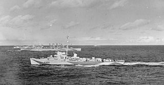
HMAS Labuan (L3501) was a Mark III Tank Landing Ship that served in the Royal Navy during World War II, and with the Royal Australian Navy (RAN) from 1946 until 1951.

HMS Bickerton was a Captain-class frigate of the Buckley type during World War II. Named after Sir Richard Bickerton commander of HMS Terrible at the First Battle of Ushant during the American Revolutionary War.

Mountaineer Range is the range of mountains lying between the Mariner and Aviator Glaciers in Victoria Land, Antarctica. The seaward parts of the range were first viewed by Ross in 1841, and subsequently by several British and later American expeditions. The precise mapping of its overall features was accomplished from U.S. Navy air photographs and surveys by New Zealand and American parties in the 1950s and 1960s. Named by the New Zealand Geological Survey Antarctic Expedition (NZGSAE), 1958–59, in keeping with the backgrounds of members of the 1957–58 and 1958–59 field parties who made a reconnaissance of the area, and also in association with the names "Aviator" and "Mariner".
Gair Mesa is the southernmost mesa of the Mesa Range, in Victoria Land, Antarctica. It was named by the northern party of the New Zealand Geological Survey Antarctic Expedition, 1962–63, for H.S. Gair, geologist and leader of this party. This geographical feature lies situated on the Pennell Coast, a portion of Antarctica lying between Cape Williams and Cape Adare.

Haffner Glacier is a small glacier discharging into Berg Bay along the north coast of Victoria Land, Antarctica. It was first charted by the British Antarctic Expedition, 1898–1900, under Carsten. E. Borchgrevink, who named it for Colonel Haffner, Director of the Government Survey of Norway. This glacier lies situated on the Pennell Coast, a portion of Antarctica lying between Cape Williams and Cape Adare.

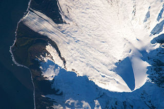
Deacock Glacier is a glacier close west of Lavett Bluff on the south side of Heard Island in the southern Indian Ocean. Its terminus is between Cape Labuan and Long Beach. To the east of Deacock Glacier is Fiftyone Glacier, whose terminus is located between Lavett Bluff and Lambeth Bluff. To the west of Deacock Glacier is Gotley Glacier, whose terminus is located between Cape Arkona and Cape Labuan.
Cape Gazert is a cape at the western end of the rocky promontory which forms the south side of South West Bay, on the west side of Heard Island in the southern Indian Ocean. This feature was known to American sealers as "Green Point", as shown by Captain H.C. Chester's 1860 sketch map and other sealer maps of the period. The present name was applied by the First German Antarctica Expedition when they landed at the feature in February 1902, after Doctor Hans Gazert, medical officer with the expedition, and it has become established in international usage.
Cape Bidlingmaier is a rocky cape at the east side of the entrance to Mechanics Bay, on the north side of Heard Island in the southern Indian Ocean. The feature appears to have been known to American sealers as Morgan's Point, as shown by Captain H.C. Chester's 1860 sketch map of the island. The name Negros Head was also in use by American sealers during the 1860–70 period. The name Bidlingmaier was applied by the First German Antarctica Expedition, under Erich von Drygalski, who made a running survey and landing along the north side of the island in 1902. Friedrich Bidlingmaier served as magnetician and meteorologist with the expedition.

Co-pilot Glacier is a short, steep tributary glacier, flowing from the western and southern slopes of Mount Overlord to the upper part of Aviator Glacier in Victoria Land. It was named by the northern party of the New Zealand Geological Survey Antarctic Expedition, 1962–63, in recognition of services rendered by pilots of U.S. Navy Squadron VX-6, and in association with nearby Pilot Glacier.
Vrana Dome is a prominent, rounded ice dome about 4 nautical miles (7 km) northeast of Statler Hills, at the east side of Amery Ice Shelf A survey station was established on the dome during the ANARE tellurometer traverse from Larsemann Hills to Reinbolt Hills in 1968. Named for A. Vrana, cosmic ray physicist at Mawson Station in 1968, who assisted in the survey.
Wakefield Reef is a reef, 0.5 nautical miles (0.9 km) across, lying 2.5 nautical miles (4.6 km) west-southwest of Cape Arkona, off the southwest side of Heard Island. The existence of a reef in this area is noted on an unpublished American sealer's map of "Hurds Island" compiled during the 1860-70 period, although the configuration of this side of the island is somewhat distorted, as were all early maps of the island. The feature was more accurately charted and named by HMS Wakefield which visited the island in April 1910.
Daykovaya Peak is a prominent peak, 1,995 metres (6,550 ft) high, rising between Mount Hansen and Kare Bench in the Westliche Petermann Range, Wohlthat Mountains. It was discovered and plotted from air photos by the Third German Antarctic Expedition, 1938–39. It was mapped from air photos and surveys by the Sixth Norwegian Antarctic Expedition, 1956–60; remapped by the Soviet Antarctic Expedition, 1960–61, and named Gora Daykovaya.

Ecology Glacier is a glacier flowing northeast into Admiralty Bay, King George Island, north of Llano Point. It was named by the Polish Antarctic Expedition, 1980, after the Institute of Ecology of the Polish Academy of Sciences, the sponsor of nearby Arctowski Station.

Cape Fie, located at 54°27′S3°28′E, is a cape marking the southeast extremity of Bouvetøya in the South Atlantic Ocean. It was first roughly charted in 1898 by a German expedition under Carl Chun, and was re-charted and named by the Norwegian expedition under Captain Harald Horntvedt who explored the area from the Norvegia in December 1927.
Cape Mousse is a small rocky cape, fringed by many small islands and backed by moraine close to the south, protruding through the coastal icecap 4.6 kilometres (2.5 nmi) southwest of Cape Decouverte. Photographed from the air by U.S. Navy Operation Highjump, 1946-47. Charted by the French Antarctic Expedition, 1949–51, and so named by them because several patches of lichens were found on the exposed rocky surfaces. "Mousse" is French for moss.
Cape Lockyer is a steep rock headland 1.5 nautical miles (3 km) northeast of Lambeth Bluff on the southeast side of Heard Island. It was surveyed in 1948 by Australian National Antarctic Research Expeditions and named by them for Lieutenant H.C.J. Lockyer, Royal Australian Naval Volunteer Reserve, one of the officers on HMAS Labuan, relief ship for the expedition.
Hayter Peak is a peak, 565 metres (1,850 ft) high, standing 0.2 nautical miles (0.4 km) west of Mount Olsen along the backbone of Laurens Peninsula, at the northwest end of Heard Island. The peak was surveyed in 1948 by the Australian National Antarctic Research Expeditions, and named by them for Alfred J. Hayter, a warrant officer on the expedition ship HMAS Labuan (L3501).

Seraph Bay is an open bay about 15 nautical miles (28 km) wide, formed at the southeast end of Thurston Island. It is bounded by Cape Annawan on the northwest, Abbot Ice Shelf on the southwest and Dustin Island on the southeast Discovered by members of the United States Antarctic Service (USAS) in flights from the ship Bear in February 1940. The bay was more accurately delineated by the U.S. Navy Bellingshausen Sea Expedition in February 1960. Named by US-SCAN for the brig Seraph of Stonington, CT, which in 1830, under Captain Benjamin Pendleton, sailed westward from the South Shetland Islands, reaching as far as 101W, south of 60S.
Lambeth Bluff is a rock coastal bluff at the east side of Fiftyone Glacier, on the south side of Heard Island. It was surveyed in 1948 by the Australian National Antarctic Research Expeditions (ANARE) and named "Cape Lambeth" for A. James Lambeth, a geologist with the expedition. Further ANARE exploration led to revision of the name in 1964 to Lambeth Bluff.


