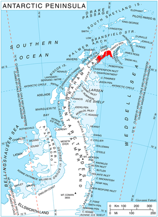
Alexander Island, which is also known as Alexander I Island, Alexander I Land, Alexander Land, Alexander I Archipelago, and Zemlja Alexandra I, is the largest island of Antarctica. It lies in the Bellingshausen Sea west of Palmer Land, Antarctic Peninsula from which it is separated by Marguerite Bay and George VI Sound. The George VI Ice Shelf entirely fills George VI Sound and connects Alexander Island to Palmer Land. The island partly surrounds Wilkins Sound, which lies to its west. Alexander Island is about 390 kilometres (240 mi) long in a north–south direction, 80 kilometres (50 mi) wide in the north, and 240 kilometres (150 mi) wide in the south. Alexander Island is the second-largest uninhabited island in the world, after Devon Island.

Thurston Island is an ice-covered, glacially dissected island, 215 km (134 mi) long, 90 km (56 mi) wide and 15,700 km2 (6,062 sq mi) in area, lying a short way off the northwest end of Ellsworth Land, Antarctica. It is the third-largest island of Antarctica, after Alexander Island and Berkner Island.

The Nimrod Glacier is a major glacier about 85 nautical miles long, flowing from the polar plateau in a northerly direction through the Transantarctic Mountains into the Ross Ice Shelf, Antarctica.
The Queen Alexandra Range is a major mountain range about 100 nautical miles long, bordering the entire western side of Beardmore Glacier from the Polar Plateau to the Ross Ice Shelf. The range is in the Transantarctic Mountains System, and is located in the Ross Dependency region of Antarctica.
The Neptune Range is a mountain range, 70 nautical miles long, lying west-southwest of Forrestal Range in the central part of the Pensacola Mountains, Antarctica. The range comprises Washington Escarpment with its associated ridges, valleys and peaks, the Iroquois Plateau, the Schmidt and the Williams Hills.
The Cook Mountains is a group of mountains bounded by the Mulock and Darwin glaciers in Antarctica. They are south of the Worcester Range and north of the Darwin Mountains and the Britannia Range.

The Darwin Glacier is a large glacier in Antarctica. It flows from the polar plateau eastward between the Darwin Mountains and the Cook Mountains to the Ross Ice Shelf. The Darwin and its major tributary the Hatherton are often treated as one system, the Darwin–Hatherton.
Foundation Ice Stream is a major ice stream in the Pensacola Mountains of Antarctica. The ice stream drains northward for 150 nautical miles along the west side of the Patuxent Range and the Neptune Range to enter the Ronne Ice Shelf westward of Dufek Massif.
The Mulock Glacier is a large, heavily crevassed glacier which flows into the Ross Ice Shelf 40 kilometers south of the Skelton Glacier in the Ross Dependency, Antarctica.

Crane Glacier, is a narrow glacier which flows 30 miles (50 km) in an east-northeasterly direction along the northwest side of Aristotle Mountains to enter Spillane Fjord south of Devetaki Peak, on the east coast of the Antarctic Peninsula. Sir Hubert Wilkins photographed this feature from the air in 1928 and gave it the name "Crane Channel", after C.K. Crane of Los Angeles, reporting that it appeared to be a channel cutting in an east-west direction across the peninsula. The name was altered to "Crane Inlet" following explorations along the west coast of the peninsula in 1936 by the British Graham Land Expedition, which proved that no through channel from the east coast existed as indicated by Wilkins. Comparison of Wilkins' photograph of this feature with those taken in 1947 by the Falklands Islands Dependencies Survey shows that Wilkins' "Crane Channel" is this glacier, although it lies about 75 miles (120 km) northeast of the position originally reported by Wilkins.

Flask Glacier, is a gently-sloping glacier, 25 nautical miles long, flowing east from Bruce Plateau to enter Scar Inlet between Daggoo Peak and Spouter Peak in Graham Land, Antarctica. The lower reaches of this glacier were surveyed and photographed by the Falklands Islands Dependencies Survey (FIDS) in 1947. The entire glacier was photographed by the Falkland Islands and Dependencies Aerial Survey Expedition in 1955–56, and mapped by the FIDS in 1957. It was named by the UK Antarctic Place-names Committee after the third mate on the Pequod in Herman Melville's Moby-Dick; or, The White Whale.
The Nash Range is a mainly ice-covered coastal range in the Churchill Mountains of Antarctica.

Nicholson Peninsula is a broad ice-covered peninsula about 15 nautical miles (28 km) long, between Couzens Bay and Matterson Inlet on the Shackleton Coast on the west side of the Ross Ice Shelf, Antarctica.
The Darley Hills are a range of high, ice-covered coastal hills in the Churchill Mountains, Antarctica.
The Duncan Mountains are a group of rugged coastal foothills, about 18 nautical miles long, extending from the mouth of Liv Glacier to the mouth of Strom Glacier at the head of the Ross Ice Shelf in Antarctica.

Eliason Glacier is a glacier 5 nautical miles (9 km) long close west of Mount Hornsby, flowing south from Detroit Plateau into the ice piedmont north of Larsen Inlet, Nordenskjöld Coast in northern Graham Land, Antarctica. It was mapped from surveys by the Falkland Islands Dependencies Survey (1960–61), and was named by the UK Antarctic Place-Names Committee after the Eliason motor sledge, invented in 1942 in Sweden, now made in Canada, and used in Arctic Canada since 1950 and in the Antarctic since 1960.
Fleming Glacier is a broad glacier 25 nautical miles (46 km) long on the west side of the Antarctic Peninsula, flowing west-northwest and terminating in Forster Ice Piedmont to the east of the Wordie Ice Shelf. The glacier was charted by the British Graham Land Expedition (BGLE) under John Rymill, 1934–37, and was photographed from the air by the United States Antarctic Service on September 29, 1940. This hitherto unnamed feature was named by the Advisory Committee on Antarctic Names in 1947 for Reverend W.L.S. Fleming, Dean of Trinity Hall, Cambridge University; also, chaplain, chief scientist, and geologist of the BGLE.
Mercator Ice Piedmont is a gently-sloping ice piedmont at the head of Mobiloil Inlet, formed by the confluence of the Gibbs, Lammers, Cole and Weyerhaeuser Glaciers in eastern Graham Land, Antarctica. The feature was first photographed from the air by Lincoln Ellsworth in November 1935, and was plotted from these photos by W.L.G. Joerg as the lower end of a "major valley depression" along the coast. It was first seen from the ground by Finn Ronne and Carl R. Eklund of the United States Antarctic Service, 1939–41, which also obtained air photos. The ice piedmont was surveyed by the Falkland Islands Dependencies Survey in December 1958, and was named by the UK Antarctic Place-Names Committee after Flemish mathematician and geographer Gerardus Mercator, the originator, in 1568, of the map projection which bears his name.
Ramsey Glacier is a glacier about 45 nautical miles long in Antarctica. It originates in the Bush Mountains near the edge of the polar plateau and flows north through the Queen Maud Mountains of Antarctica to the Ross Ice Shelf eastward of Den Hartog Peak.

Lister Glacier is a glacier 5 nautical miles (9 km) long and 1 nautical mile (2 km) wide, draining the northeast slopes of Stribog Mountains and flowing into Bouquet Bay just south of Duclaux Point on the northeast side of Brabant Island, in the Palmer Archipelago, Antarctica.


